It is now almost five years since the Icelandic volcano Eyjafjallajkull brought much of Europe to a standstill.
The 2010 eruptions blanketed the continent with a thick ash cloud that brought chaos to the air industry.
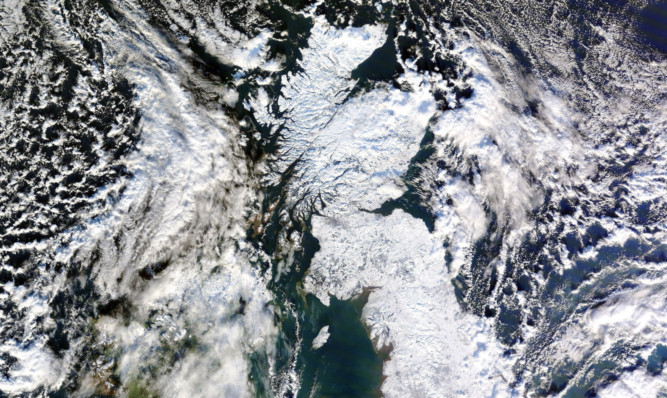
As the drama unfolded over days, satellite images of the impact were beamed around the world many of them originating in Dundee.
The stunning pictures were captured by the city’s Satellite Receiving Station, which is celebrating its 40th anniversary this month.
Drawing data from satellites high above the Arctic and Antarctic, it receives and archives thousands of detailed images of the Earth.
Over the years, the station has received many iconic images of major storms, such as those that captured the entire UK covered in snow in 2010.
Media outlets across the UK and around the world regularly use such images and those of major world events such as the Icelandic eruptions to bring their stories to life.
World events as diverse as wildfires and shifting sea ice can also be tracked by scientists using the information.
Dundee University electrical and electronic engineering lecturers Peter Baylis and John Brush oversaw the installation of the station’s first dish-type tracking antenna on the roof of the Ewing Building back in 1975.
Although the pair retired a few years ago, the original dish remains now part of a five-strong network of tracking antennas mounted on rooftops across the campus.
Today, the station is part of the university’s Space Technology Centre and remains the only one of its kind in Scotland.
It is one of only a handful in the UK capable of providing detailed images of the Earth’s atmosphere and surface, through its use of satellites operated by Eumetstat and US organisations the NOAA and Nasa.
Manager Neil Lonie said the station’s main function was to support UK environmental scientists with data, though there are other users across Europe and further afield.
“We work closely with the Plymouth Marine Laboratory, which uses our data to generate information such as sea surface temperatures and chlorophyll levels for marine scientists, together with directing research ships and locating marine features of particular interest,” he said.
“Our data is also used in areas such as monitoring volcanic activity, sea ice, vegetation cover, wildfires and obviously in meteorology.”
Data can be viewed at www.sat.dundee.ac.uk.