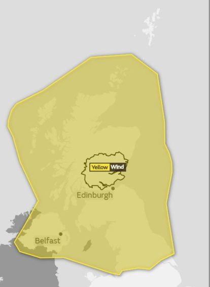
Scotland is bracing for winds of up to 70mph as Storm Hector approaches.
Locals across Tayside and Fife have been told to prepare for blustery conditions overnight and into Thursday, with the whole of the country covered by a Met Office yellow warning for wind.
Westerly gales are likely to be between 50mph and 60mph in speed but could reach up to 70mph in exposed locations before easing in the afternoon.
The Met Office said the period of “very windy” conditions could cause power cuts and affect motorists as well as rail, air and ferry travel.
The Met Office warning also states that there is a “small chance” of “injuries and danger to life” in coastal areas as a result of large waves and beach material being “thrown onto sea fronts, coastal roads and properties”.
The organisation added that “flying debris” could also pose a risk to people and that buildings could be damaged.
The West Coast of Scotland is expected to be the worst affected area, with gusts of up to 70mph possible.
The weather warning is in effect from 3am until 3pm on Thursday.
Traffic Scotland said locals in Courier Country should prepare for restrictions on both the Tay Road, Friarton and Forth Road bridges, as well as the Queensferry Crossing.
The organisation has compiled a list of the “possible” impacts on Scotland’s major crossings.
Between 3am and 6pm on Thursday the Tay Road Bridge may be closed to double decker buses. Traffic Scotland said it may be shut to “all vehicles” for “brief spells” between 10am and 11am.
There could also be restrictions on the Friarton Bridge between 7am and 4pm. For the full list of predicted restrictions, click here.
Met Office issues warning for Tayside and Fife as Scotland braces for ‘very windy weather’
Scottish transport minister Humza Yousaf said: “Yellow warning in place for strong winds covering most of Scotland tomorrow as Storm Hector makes his presence felt.
“We are going to feel it during Thursday morning rush hour in particular. As always, leave extra time for your journey and plan ahead.”
Traffic Scotland said: “Storm Hector will bring a spell of very windy weather on Thursday with gusts of 50-60mph likely.
“There is a small chance of longer journey times or cancellations as road, rail, air and ferry services are affected.”
?REMEMBER?@metoffice YELLOW weather warning for WIND has been issued for tomorrow ⚠️
? 3am – 3pm for all areas ?
For more info check: https://t.co/Pz0UxUJ0FQ & #BeSafe ❤️ pic.twitter.com/iXCCj5npQB
— Traffic Scotland (@trafficscotland) June 13, 2018
The Met Office yellow warning states: “A very windy spell will develop during Wednesday night in association with a deep area of low pressure.
“The strongest winds will reach the west coast during the early hours of Thursday before spreading eastwards during the day.
Yellow Warning in place for strong winds covering most of Scotland tomorrow as Storm Hector makes his presence felt.
We are going to feel it during Thursday morning rush hour in particular.
As always, leave extra time for your journey and plan ahead. Follow @trafficscotland pic.twitter.com/DwBl5HHejv
— Humza Yousaf (@HumzaYousaf) June 13, 2018
“Westerly winds are likely to gust between 50mph and 60mph in many areas and possibly around 70mph in some exposed locations.
“Winds should gradually ease from the west during Thursday afternoon. In addition, a spell of heavy rain will accompany the wind with the highest rainfall totals over parts of western Scotland.”
Director of service delivery at Scots ferry operator CalMac, David Gibson, said: “As always when stormy weather is forecast, people should check their travel arrangements before leaving the house.
“Our website and social media feeds will be updated constantly as the latest information becomes available.
“With such a broad forecast it is difficult to pin down individual routes that will be affected the most, however, we expect significant disruption tomorrow morning.
“The Met forecast is for winds to die down moving into Thursday afternoon.
“Even though winds weaken over the course of tomorrow there is every chance that vessels will be out of position resulting in a disruption knock on effect for the rest of the day.
“I would urge people to check the latest service status before they travel and also consider signing up for our text alert service.”