Calendar An icon of a desk calendar. Cancel An icon of a circle with a diagonal line across. Caret An icon of a block arrow pointing to the right. Email An icon of a paper envelope. Facebook An icon of the Facebook "f" mark. Google An icon of the Google "G" mark. Linked In An icon of the Linked In "in" mark. Logout An icon representing logout. Profile An icon that resembles human head and shoulders. Telephone An icon of a traditional telephone receiver. Tick An icon of a tick mark. Is Public An icon of a human eye and eyelashes. Is Not Public An icon of a human eye and eyelashes with a diagonal line through it. Pause Icon A two-lined pause icon for stopping interactions. Quote Mark A opening quote mark. Quote Mark A closing quote mark. Arrow An icon of an arrow. Folder An icon of a paper folder. Breaking An icon of an exclamation mark on a circular background. Camera An icon of a digital camera. Caret An icon of a caret arrow. Clock An icon of a clock face. Close An icon of the an X shape. Close Icon An icon used to represent where to interact to collapse or dismiss a component Comment An icon of a speech bubble. Comments An icon of a speech bubble, denoting user comments. Comments An icon of a speech bubble, denoting user comments. Ellipsis An icon of 3 horizontal dots. Envelope An icon of a paper envelope. Facebook An icon of a facebook f logo. Camera An icon of a digital camera. Home An icon of a house. Instagram An icon of the Instagram logo. LinkedIn An icon of the LinkedIn logo. Magnifying Glass An icon of a magnifying glass. Search Icon A magnifying glass icon that is used to represent the function of searching. Menu An icon of 3 horizontal lines. Hamburger Menu Icon An icon used to represent a collapsed menu. Next An icon of an arrow pointing to the right. Notice An explanation mark centred inside a circle. Previous An icon of an arrow pointing to the left. Rating An icon of a star. Tag An icon of a tag. Twitter An icon of the Twitter logo. Video Camera An icon of a video camera shape. Speech Bubble Icon A icon displaying a speech bubble WhatsApp An icon of the WhatsApp logo. Information An icon of an information logo. Plus A mathematical 'plus' symbol. Duration An icon indicating Time. Success Tick An icon of a green tick. Success Tick Timeout An icon of a greyed out success tick. Loading Spinner An icon of a loading spinner. Facebook Messenger An icon of the facebook messenger app logo. Facebook An icon of a facebook f logo. Facebook Messenger An icon of the Twitter app logo. LinkedIn An icon of the LinkedIn logo. WhatsApp Messenger An icon of the Whatsapp messenger app logo. Email An icon of an mail envelope. Copy link A decentered black square over a white square.

New app launched to target soil erosion

SAVING THE LAND: The new app will help us understand the scale of the problem.

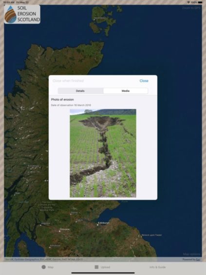
A new app has been created to help farmers and scientists understand the  scale of soil erosion in Scotland.

It will also help users identify the different types of soil erosion and allow them to contribute records and images which can be shared with other users.

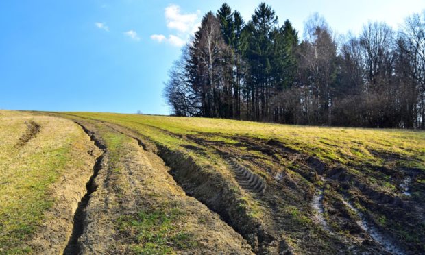
Dr Allan Lilly, a soil scientist at the James Hutton Institute (JHI) and one of the researchers behind the app, explained that erosion occurs when soil particles break off from the soil surface and are moved across the land either by flowing water or by the wind.

“We find erosion occurring across the country, in both the uplands and the lowlands. Footpath erosion can also occur in localised areas,” he said.

The app is a quick, easy way to learn about soil erosion.

“The most obvious effect of soil erosion is the loss of soil. You may have seen soil washed out of fields and onto roads or into rivers and streams.

“This is not just bad for farming through the loss of soil and nutrients but the nutrients in the eroded soil can pollute our rivers and the soil particles themselves can smother the riverbeds, damaging breeding grounds for fish. Erosion of peat soils can also cause water pollution but also release the greenhouse gas, carbon dioxide, into the air.”

Records

Data on Scotland’s soils and landscape, acquired over many years, is already held by JHI and has been used to develop a model and maps of the risk of erosion happening.

App users will be asked to answer some questions to improve the understanding of where, when and why erosion occurs and help find ways to reduce its harmful effects. Users will be able to upload their records and photos whenever they find evidence of the problem.

Dr Lilly said: “We are keen to hear from land managers, members of the public and other agencies if you think the soil erosion recording app is useful in helping to reduce soil erosion and if you are likely to use it. We are also interested in what disadvantages you see in having this app and website available to everyone. Please send responses to jhiapps@hutton.ac.uk ”

The Soil Erosion Scotland app is available for iOS and Android devices  and is free to download and use. To download it visit the App Store at http://bit.ly/SoilErosion-iOS or Google Play store http://bit.ly/SoilErosion-Android.