Wolf Craig, Glen Esk, Angus
It was business as usual on the track up Glen Mark, a steady stream of walkers heading for the popular Munro summit of Mount Keen.
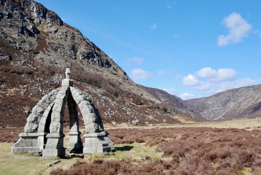
Solitude wasn’t far, though. Just beyond the familiar landmark of Queen’s Well I branched left away from the throng on the path that ran alongside the brilliant blue line of the Water of Mark to go in search of Balnamoon’s Cave.
This was one of the hideaways of rebel laird James Carnegy, the 6th Earl of Balnamoon, a wanted man after the Battle of Culloden, and it is well concealed among the rock and heather confusion of the landscape.
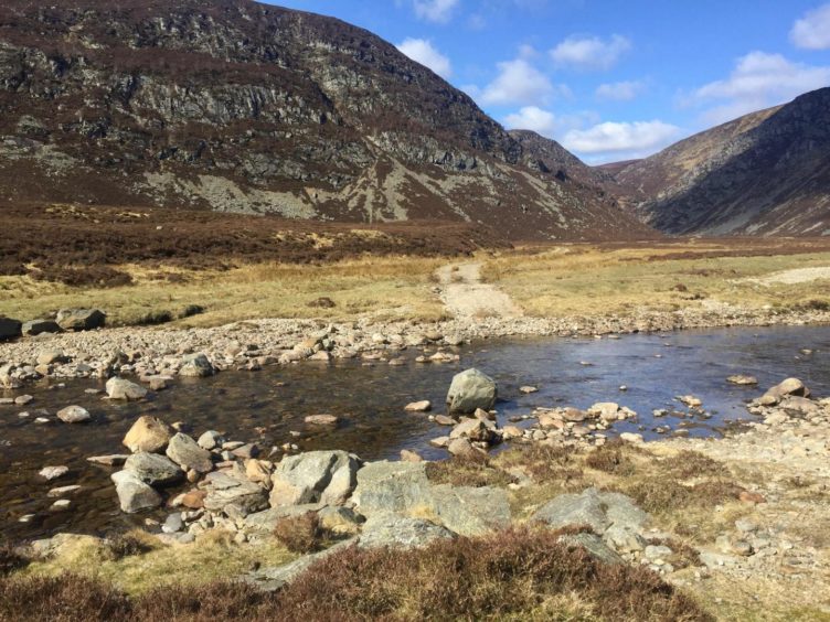
The first obstacle was where the track crossed the water, but the recent lack of rain meant this was achieved with dry feet. If the water is running high, there are several places further on where it is possible to get safely across.
As the path wound its way ahead through increasingly rugged terrain, it felt as if the walls were closing in, with the brooding rocky pyramid of Craig of Doune looking particularly imposing.
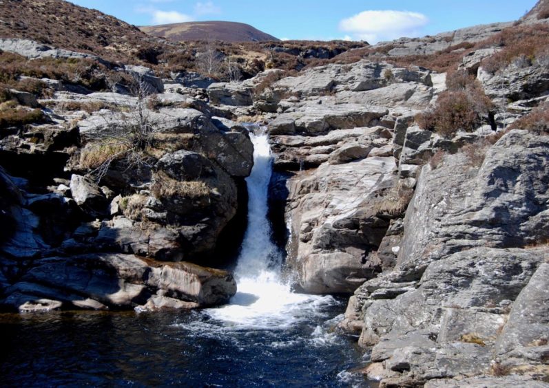
The path starts to rise above the water but I couldn’t resist dropping back down to enjoy a lunch break and a little sunbathing on the baking slabs above a series of beautiful cascades and rock pools.
The elusive cave is not far beyond this point on your left and the search and discovery will delight youngsters of all ages.
Those happy with a shorter, less strenuous day out can retrace their steps from here. I carried on a little further, passing beyond the next idyllic waterfall then taking to the rough slopes on the left.
The initial ascent was steep and pathless but it was momentary and never difficult, and I was soon at the small cairn of the minor summit looking over to Wolf Craig.
The going was softer and boggier on the short hop west, but the rise was imperceptible and I was soon standing amid the five cairns that curiously crown the summit area of Wolf Craig. It was hard to believe this bare and windswept place was once covered in trees, a perfect habitat for wolves.
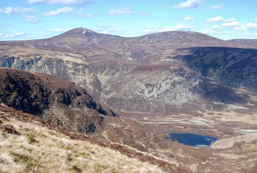
Lochnagar’s sharp and precise contours stood out on the horizon and there were fine views to Mount Keen, while the vast rolling line of the more distant Cairngorms seemed like the beginnings of a far-off country.
If there were no wolves, at least there was an adder, a pale specimen draped like tinsel over sprigs of heather, stopped mid-escape by my sudden presence, and there were plenty of hares leaping out and dashing in every direction.
It felt a long way round over spongy and mostly pathless ground, but there was the solace of a view down to the concealed ink well of Carlochy, its dark waters cradled by muscular, rocky arms.
It’s possible to make a descent from here, a direct line south bringing you out in the lower reaches of Glen Lee, but I continued on to the summit of Monawee.
The wide path doglegs south-east then east to a cairn but the descent involves some complex route finding through crags, so I decided it was a better bet to drop off early to reach the track along the side of Loch Lee. Even then there was a bit of dodging around to find the simplest line.
The walk back along the lochside track was a pleasant way to finish, the still waters continually changing shade and tone as the sun began its long journey to the end of another day.
There were families out for an evening stroll, the first people I had seen since Queen’s Well. Going against the flow had given me hours of perfect solitude.
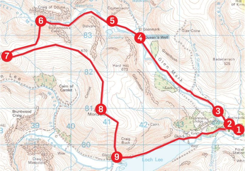
ROUTE
1. From car park, walk west along road, passing Lochlee Parish Church.
2. Just before bridge, turn right on to Mounth Road track (signed for Queen’s Well and Mount Keen). Go left when track splits below House of Mark, then through gate.
3. Stay on main track up Glen Mark, passing through high metal gate and ignoring tracks branching right then one dropping left to bridge, until you reach Queen’s Well.
4. Leave main track just beyond this point and take left branch, crossing Water of Mark at ford. If water is high, it may be easier to cross further on.
5. Follow path by water, passing series of little waterfalls, as it rises through heather. After reaching larger waterfall, head south up rough pathless slope to reach minor top.
6. Continue on faint path west for less than 1km to Wolf Craig summit.
7. Return east over minor top then follow the wide ridge line as it gradually curves south to Monawee.
8. Drop south-east at first from summit cairn then south with care to outflank craggy ground to reach track along side of Loch Lee.
9. Follow track along loch past old church and cemetery then through woods and past Invermark Castle to car park.
INFORMATION
Distance: 17.5km/11miles
Ascent: 595m/1,950ft
Time: 5-7 hours
Grading: Estate tracks, hill paths and rough pathless terrain. Steep ascent of Wolf Craig, care needed on descent from Monawee, suitable for walkers with reasonable level of fitness and relevant hill skills. Walk there and back into Glen Lee is suitable for all ages.
Start/finish: Car park at Invermark, 6km west of Tarfside, Glen Esk (Grid ref: NO 446804).
Map: Ordnance Survey 1:50,000 Landranger Map 44 (Ballater & Glen Clova); Ordnance Survey 1:25,000 Explorer sheet 395.
Tourist Information: Dundee iCentre, 16 City Square, Dundee DD1 3BG (Tel 01382 527527).
Public transport: None.


