Ben Gulabin has long been something of a ski season standby, a hill to climb if conditions on the slopes of Glenshee above were too poor to warrant the purchase of a lift pass, or if the road over the unyielding Devil’s Elbow was snowbound.
As such, I have been up and down it quite a few times over the years and it always presents a decent test of stamina, rewarded, on a clear day, with some great mountain vistas.
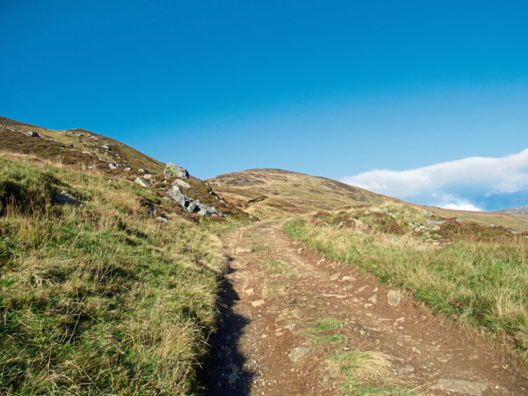
The approach is strenuous but uncomplicated, a track striking out from the roadside north of the snow gates at Spittal of Glenshee, a path above rising steeply over the heather-clad northern flank to the summit.
It is uphill from the off, the track passing a sign warning of any shooting on the hills (part of the Invercauld Estate, stalking takes place in the hills here between mid-September and October 20, although there is no stalking on Sundays) before beginning its ascent towards the col between Ben Gulabin and Creagan Bheithe.
It was on the southern spur of the latter peak that the seeds of Scotland’s ski industry were sown over 70 years ago and there are still some remnants of early experiments with uplift.
At the start of the 20th century, devotees brought the sport to Britain after learning to ski on the Continent and, in the post-war years, many climbers took to the snow during the winter months, hauling ex-army skis into mountain ranges like the Cairngorms.
In the winter of 1948, members of Dundee Ski Club built a hut on the slopes of Creagan Bheithe and, in 1950, they erected the first mechanised tow in Britain on Mount Blair, a few miles to the south.
After crossing the crisp, clear waters of the Allt a’Charnaich, the track passes below the site of the hut (all that now remains is the base and some debris) and, close by, the wheel of a tow that ran up the hill.
Higher up the slope, one of the metal frames from which the rope was suspended still stands and it is fair to say that it was here that the foundations were laid for the establishment of the Glenshee Ski Area, further up the glen, in 1956.
In the pass above the collapsed hut, the route branches left off the main gravel road, dipping briefly to cross the burn once again, the soft ground less squelchy if there is a hard frost underfoot.
The way then climbs sharply, a rough, peaty track clambering past a line of grouse butts above which the way narrows into a firmer path ahead of a junction that lies between the summit, to the right, and the lower south-east top, to the left.

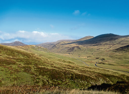
Weaving up through rocky outcrops, I was soon standing atop Ben Gulabin, a Corbett for those who like to categorise their hills, enjoying magnificent mountain panoramas.
To the north-west, the coire below the summit of Glas Tulaichean was distant but distinct with a lip of snow while, to the north-west, Carn a’Gheoidh and The Cairnwell caught my eye.
Closer to home, the south-east top promised a bird’s eye view down Glen Shee, so I scampered through the heather, out on to the prow where, with the winter sun shining bright and the sky blue, I was not disappointed.

ROUTE
1. Pass through roadside gate and ascend track north.
2. Cross Allt a’Charnaich and continue up track to junction in col below Ben Gulabin.
3. Turn left, dipping to cross stream, and ascend initially rough, peaty track running past grouse butts then path to junction.
4. Turn right and ascend path through rocky outcrops to summit.
5. Return to point 4 and continue ahead, on path across col, to ascend southern top, continuing south along spur to outlying cairn.
6. Return north over southern top and descend path to re-join track descending by grouse butts to point 3 then retrace steps down track to road.
INFORMATION
Distance: 6.5km/4 miles
Ascent: 460m/1500ft
Time: 2-3 hours
Grading: Challenging hike with a strenuous ascent to an exposed hill summit, following good tracks and paths. Go well equipped for all weathers and keep dogs under close control due to livestock and ground nesting birds
Start/finish: Track-end with limited parking in one of two laybys 1.5km north of Spittal of Glenshee on A93 (Grid ref: NO 114714)
Map: Ordnance Survey 1:50,000 Landranger sheet 43; Ordnance Survey 1:25,000 Explorer sheet OL52
Tourist Information: Perth iCentre, 45 High Street, Perth PH1 5TJ (Tel 01738 450600)
Public transport: Stagecoach bus number 71 offers a limited service from Blairgowrie to Spittal of Glenshee (no Sunday service)