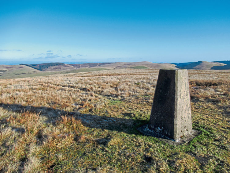
Steele’s Knowe is one of the highest peaks in the eastern tranche of the Ochil Hills, its trig point perched atop a broad, grassy and oft windswept plateau bounded by Glen Devon to the south.
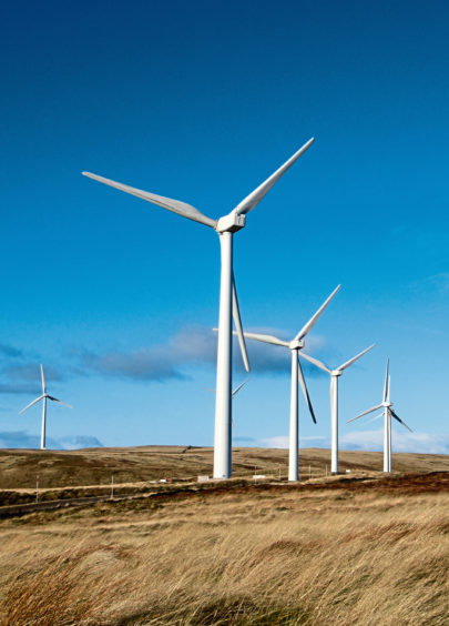
The most direct route to the top is from this snaking river valley, but, in truth, it is a pretty uninspiring tramp, relying heavily on tracks laid to serve Green Knowes Windfarm, which has come to dominate the hill.
While there is no escaping the towering turbines, an approach from the Dunning Glen road, to the east, via Corb Glen, offers a diverse blend of terrain and views and is arguably much more satisfying.
The more northerly of two small Forestry Commission car parks both named Littlerig was my starting point and, skating over a rather icy Dunning Road, I headed up the Corb Glen track, skirting between young plantations towards the abandoned hill farm at Corb.
There are some broad, muddy puddles to negotiate before the way dips, the rough, stony but much firmer track weaving through a tight, shadowy cleft between Corb Law and John’s Hill before emerging on to open grazing land beyond a makeshift metal gate.
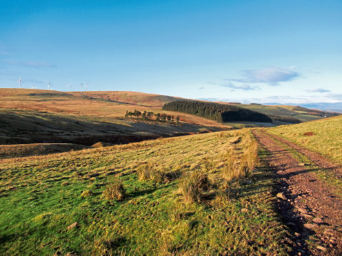
Rounding the bend, I spotted Steele’s Knowe to the west, the skeletal white outlines of wind turbines bristling along the skyline.
Descending towards Coulshill, the right of way branches left at a fallen signpost (the junction is roughly level with a copse of scattered pine trees on the other side of the valley), dropping over a grassy slope to a tall wooden pole, to the right of which I hopped across Coul Burn.
A wee path curves through bracken beyond to meet Cadgersgait, a former old drove road that, in the latter part of the 18th century and throughout the 19th century, was well used by farmers moving livestock between Dollar and Auchterarder. It takes its name from the itinerant traders, known as cadgers, who also plied the route, primarily to avoid the toll roads.
Now a grassy upland byway used by walkers and mountain bikers, the trail climbs steadily south, peaking in Cadgers’ Yett, the pass lying between Green Law and Steele’s Knowe.
Leaving the drove road to its onward journey down through Borland Glen to Glen Devon, I branched right, ascending rough vehicle tracks running parallel with the fence line to the wind farm.
From below the swooping blades of turbine number 14 (there are 18 in all), gravel roads laid to service the windfarm lead west to turbine number five which stands just a few hundred metres from the summit of Steele’s Knowe.
On a clear day, views abound from the lonely trig point, Ben Effrey, Craig Rossie and Rossie Law neighbours to the north, Auchterarder nestling in the valley below, while, to the south-west, lie the higher Ochil tops.
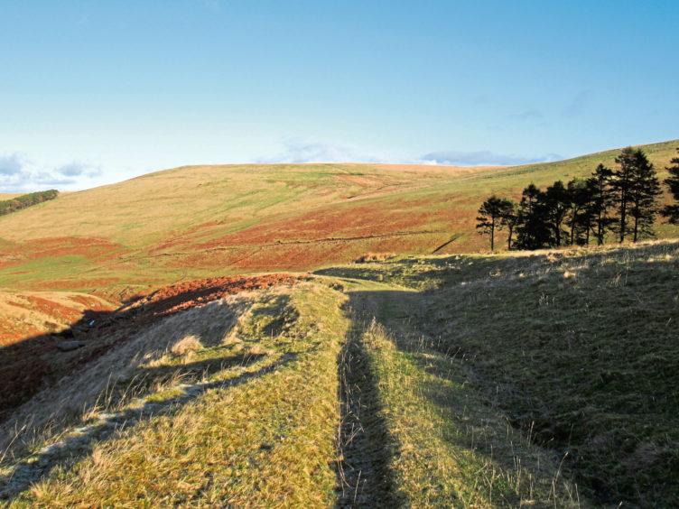
With the scree-fringed summit of distant Ben Effrey fixed in my sights, I cut a line north through the heather, the initially slim path broadening out into all-terrain vehicle tracks descending to a small triangular-shaped copse of conifers at the top of fenced pasture.
Posts and wire guided me east from here, along the top of the enclosed grazing, and, swinging left beyond a metal gate, I dropped through bracken and a band of tall, slender Scots pines to re-join the old Cadgersgait road in the base of the glen.
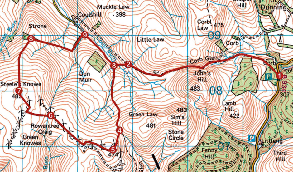
ROUTE
1. Cross road, go through gate and follow Corb Glen track 3.3km west.
2. At fallen signpost, descend left to tall post by Coul Burn. Bear right, crossing stream, and follow path through bracken to pedestrian gate.
3. Go through gate, turn left (signed Glendevon) and ascend track 1.3km to Cadgers’ Yett col.
4. Pass through broken gate and branch right, ascending heathery track to wind turbine number 14.
5. Proceed west through gate/cattle grid along windfarm track for 600m to junction. Turn right and continue 800m along track to next junction.
6. Fork left, ascending track to wind turbine number five, then proceed north-west to trig point.
7. Descend north on initially slim path to small triangle of woodland.
8. Bear right, descending by fence to gate. Cross gate and swing left, dropping through band of woodland to meet track beyond stream crossing.
9. Turn right, ignore grassy track branching right. and ascend track running by stream to point 3. Retrace steps to Littlerig.
INFORMATION
Distance: 14km/8¾ miles
Ascent: 520m/1720ft
Time: 4 hours
Grading: Moderately challenging upland route for fit hillwalkers following tracks and paths with some strenuous, prolonged ascent. Go equipped for all conditions and keep dogs under close control over grazing land
Start/finish: Forestry Commission Littlerig car park, by Corb Bridge, five miles south of Dunning on B934 Dunning Glen road (Grid ref: NO 016082)
Map: Ordnance Survey 1:50,000 Landranger sheet 58; Ordnance Survey 1:25,000 Explorer sheet 366 and 369
Tourist Information: Perth iCentre, 45 High Street, Perth PH1 5TJ (Tel 01738 450600)
Public transport: None