The grave of Scotland’s famous cattle reiver and retriever Rob Roy MacGregor lies in the shadow of Balquhidder Parish Church.
There has long been speculation, however, that the body of the outlaw, who died from wounds sustained in a duel in December 1734, may have been interred elsewhere, possibly at the MacGregor ancestral burial ground on the island of Inchcailloch, on Loch Lomond, or in Glen Gyle, at the west end of Loch Katrine, where he was born.
Whatever the truth, the grave of MacGregor, his wife Mary and the couple’s two youngest sons, with its antiquated carved flat slabs and more recent headstone and railings, draws thousands of visitors to the kirkyard each year.
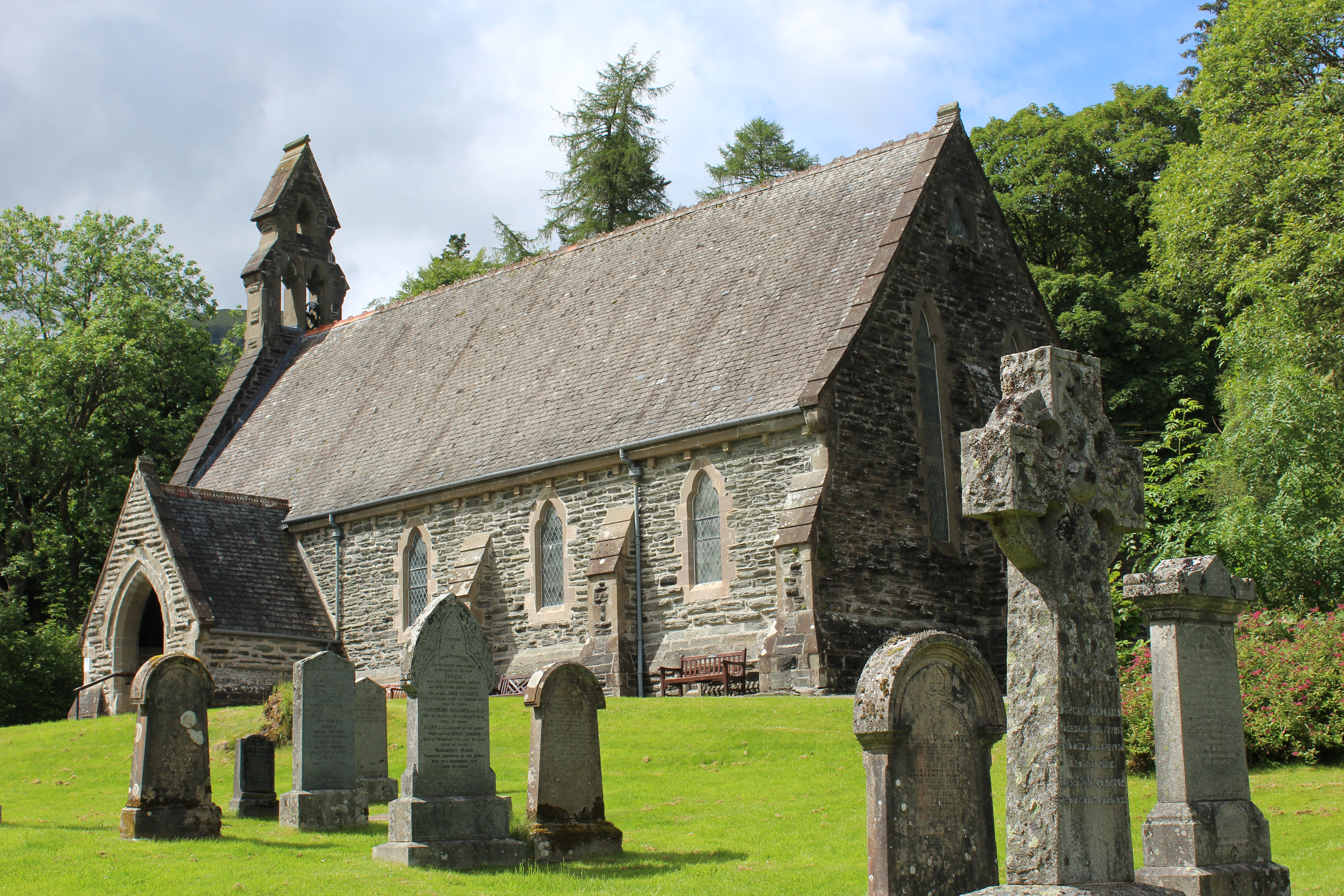
Few venture much further than the church but, behind this picturesque mid-19th century place of worship, afforested Kirkton Glen offers a surprisingly scenic hike, track and path climbing through the trees to a remote upland lochan and, nearby, a legendary MacGregor bolthole.
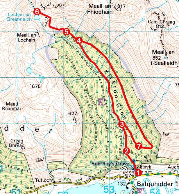
From an information board highlighting Rob Roy’s links with the local area, the path leading into the forest runs along the eastern wall of the cemetery, entering the plantation at a Forestry Commission sign from where it ascends quite steeply to a fenced compound.

The gradient eases here, the onward track – lined with pink foxgloves when I visited – following Kirkton Burn upstream through a wide swathe of cleared land, slender pines towering above younger conifers either side of me.
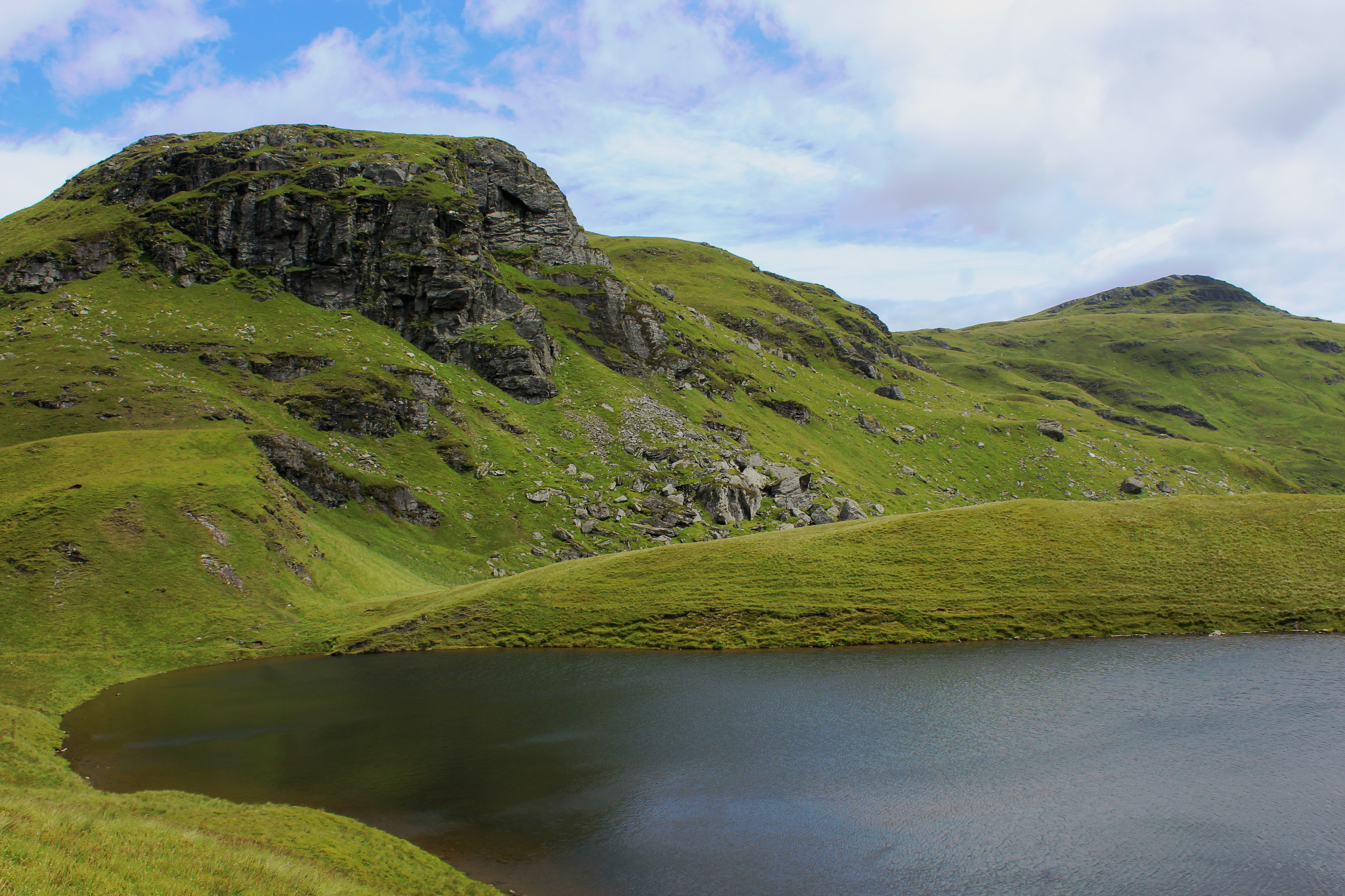
Ahead, the rocky flanks of Leum an Eireannaich and Meall an Fhiodhain present a seemingly impassable headwall above the treeline. There is, however, a way through. A long-established right of way originally travelled by both drovers and cattle thieves rises out of the forest, crossing grassy slopes to a col by Lochan an Eireannaich.
These days the trail over to Glen Dochart is signed, a path branching off the track at its most northerly point, weaving up through the evergreens to a wee stile on the boundary of the woodland.

Here open hillside beckons, the route zig-zagging up over slopes grazed by sheep to a mighty boulder lying at the foot of a rockfall below the craggy bluff of Leum an Eireannaich.
Known as Rob Roy’s Putting Stone, legend has it that the MacGregor men hid here from their enemies during raids on the lands of Balquhidder.
The rock strewn slope above hides a handful of small caves and hollows, perfect places to plot ambushes on cattle drovers crossing through the isolated pass on their way from Skye and Lochaber to the markets of Aberfoyle.
Beyond the Putting Stone, the right of way tops out at the eastern end of Lochan an Eireannaich, or ‘Loch of the Irishmen’, a reference to Christian missionaries from Ireland who stayed in the area in the fifth century.
On a good day, the shoreline is a tranquil place to sit and enjoy a packed lunch before returning down the glen. However, with a chilly breeze whipping over the water, I retreated to the jumbled boulder field where, after a spot of scrambling, I found a more sheltered crevice where I hunkered down to tuck into my sandwiches.
Below me, the forested flanks of Kirkton Glen drew my eyes towards the distant peaks of the Trossachs, a vista Rob Roy himself may have stolen a glance at during his forays through the Braes of Balquhidder.
ROUTE
1. From information board in car park, follow path along eastern edge of churchyard to Kirkton Glen sign. Pass between boulders and ascend forest path to junction by fenced compound.
2. Continue ahead (north) on forest track to next junction.
3. Ignoring tracks branching left and right, continue straight ahead on track rising north through Kirkton Glen.
4. Leave track and ascend path (signed Glen Dochart Path) through conifers.
5. Cross stile on northern edge of plantation and ascend path – boggy in places – over open hillside to Lochan an Eireannaich.
6. Retrace steps back down to point 4, turn left and follow forest track south.
7. Ignore red waymarked path branching left and continue down forest track to point 3. Turn left and descend to church.
INFORMATION
Distance: 10.8km/6¾ miles
Ascent: 500m/1650ft
Time: 3-4 hours
Grading: A moderate route following forest tracks and paths to upland lochan with prolonged and, in places, strenuous, ascent. Keep dogs under close control on open hillside where sheep graze
Start/finish: Balquhidder Parish Church, Balquhidder (Grid ref: NN 535209). Limited parking by church. Alternative parking 200m west at community hall
Map: Ordnance Survey 1:50,000 Landranger sheet 51; Ordnance Survey 1:25,000 Explorer sheet OL46
Tourist Information: Callander iCentre, 52-54 Main Street, Callander FK17 8BD (Tel 01877 330342)
Public transport: Kingshouse Travel bus service C60 from Callander stops at Kingshouse, 3km from start point


