Like plantations across the land, Blackcraig Forest has a network of tracks and paths, routes laid down by lumberjacks to plant and extract timber but ideal for exploration on foot.
While the main thoroughfares are all well mapped, there are hidden, less well travelled trails here too, including a delightfully peaceful path that climbs through a buffer of larch to the summit of Blackcraig Hill, my goal for the day.

Planted by the Forestry Commission in the 1940s and dominated by spruce, the wood has not been overly developed for recreational use, although there is a small car park on its eastern edge, accessed by track from the village of Bridge of Cally.
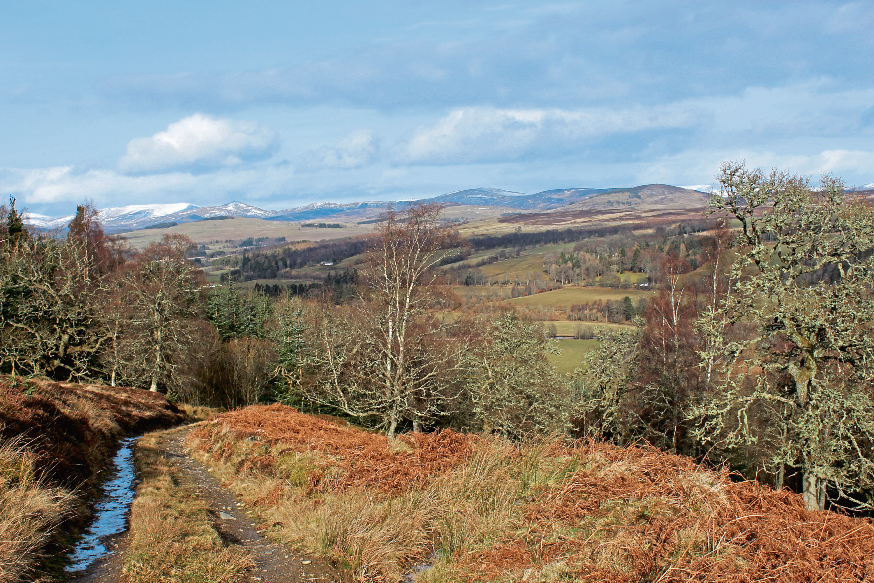
Here, I joined the Cateran Trail for the outward leg of my journey north through Strathardle and, while my old knees appreciated the level start, the track soon started to rise, crossing slopes where vast swathes of diseased trees have been felled, leaving just clumps of conifers and stray silver birches. The ground will be replanted but for now the open outlook affords excellent views.
Passing the remote cottage at Croft of Blackcraig, the track descends along the lower edge of the plantation, skirting above pasture, to the base of the valley, passing scattered houses, steadings and, concealed by trees, Blackcraig Castle.
At Crowhill, the waymarked trail detours briefly into a field on the left before settling back into its stride for the approach to Woodhill, where a herd of Belted Galloway cattle grazed the track.
Squeezing past them, I crossed below a wee waterfall and left the Cateran Trail above Woodhill Farm, branching left for the initially arduous ascent to Loch Charles.
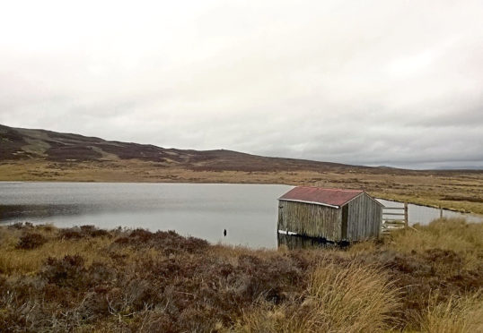
Looping up slopes studded with old oaks, the gradient eases as the track passes between ruins, the final leg to the old boatshed perched by the edge of the water refreshingly airy and comfortingly undemanding.
A deer fence stretches across the hillside but, by the boatshed, a sturdy metal gate offers a way through, a rough track rising through the heather beyond, railway sleepers and planks aiding progress over some of the muddier ground.
Higher up, the trail is easily lost but, ascending to the fence above, I picked up a line of all-terrain vehicle tracks and, after negotiating some wet, reedy ground, reached the northern tip of the forest.
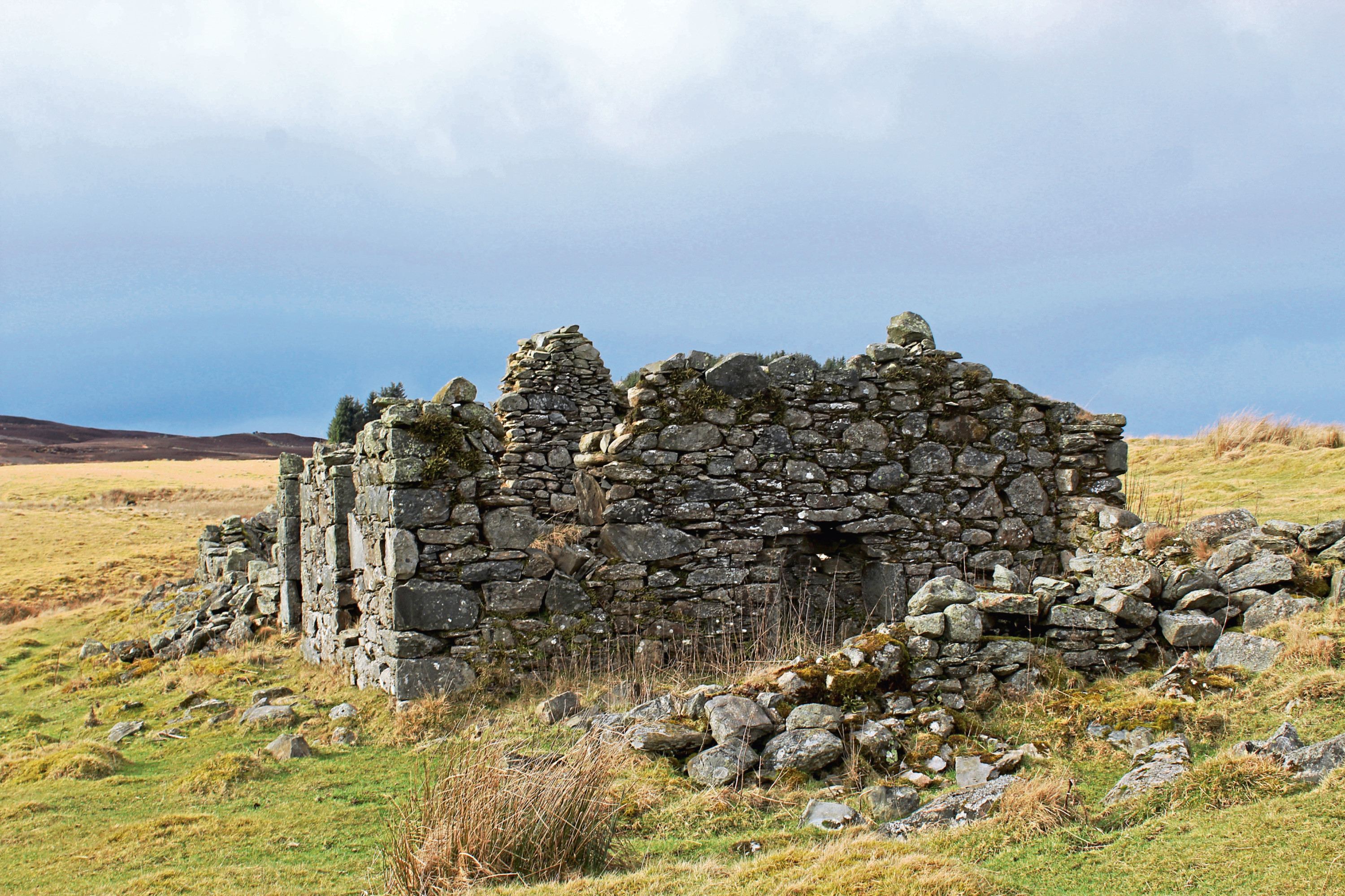
A little to the left, along the fence line, a gate offers a way back into the plantation but, when I recced this route, I opted not to use it and hiked through the heather to the top of Blackcraig Hill, believing there would, at some point, be another one.
Frustratingly, I was wrong, so this time I took advantage of the access point, a wall and parallel vehicle tracks beyond linking me into the forest road network.
My route from here to the summit – a heathery track that branched right at the end of the wall – is not mapped but it proved to be every bit as reliable as those that are, leading back out towards the fence before tunnelling below wilting boughs of larch.
Conversely, unlike this secret trail, the summit, which is obvious on the map, is less clear on the ground but, pass through a break in a wall crossing the track, and it sits up to the right, bisected by the perimeter fence.
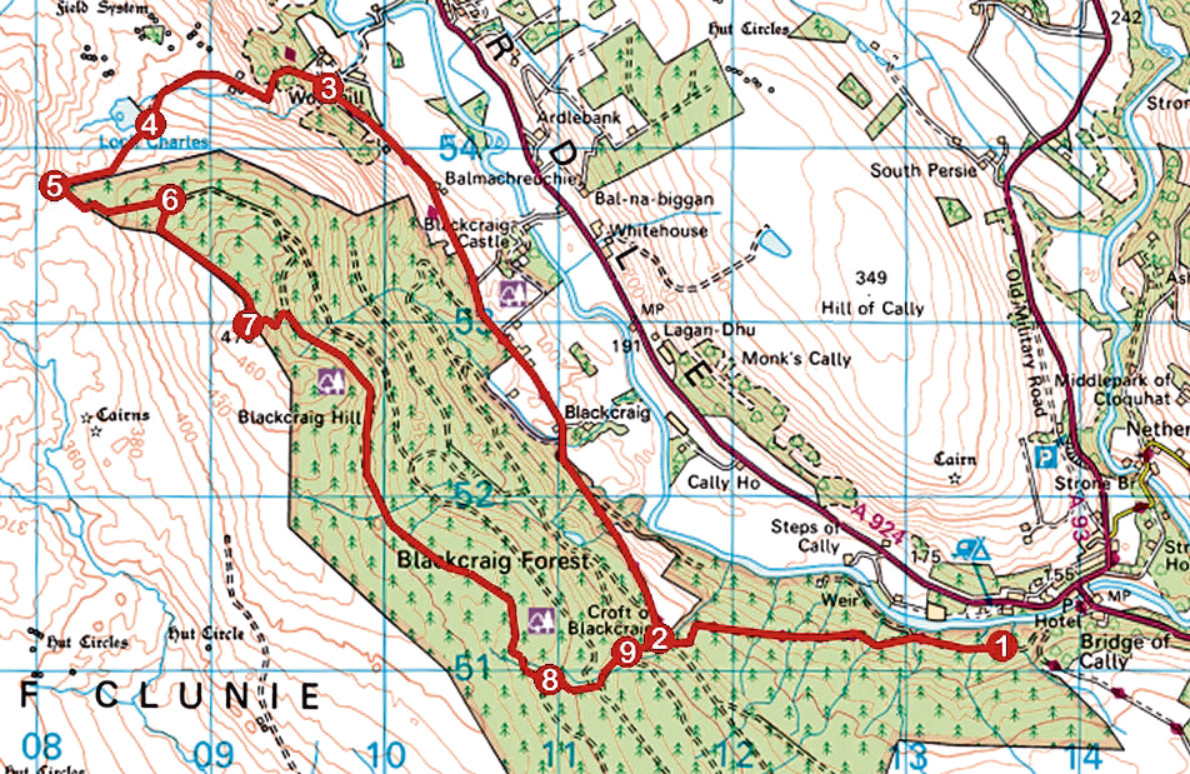
ROUTE
1. Enter forest and follow Cateran Trail up to Croft of Blackcraig.
2. Turn right past cottage and follow Cateran Trail 4km north to Woodhill.
3. Cross stream, bear left up to signed junction then fork left, leaving Cateran Trail, and ascend track to Loch Charles.
4. Go through metal gate and ascend rough track, bearing left up to plantation fence and continue west to wall.
5. Cross wall and go left along plantation fence to metal gate. Go through and go right by fence to wall. Turn left along wall to track junction.
6. Turn right, ascending towards fence then up to Blackcraig Hill summit.
7. Pass through gap in wall and turn left, descending path to meet forest road. Turn right.
8. After 3km, bear left and, ignoring tracks branching left and right, descend to cross stream.
9. Below stream crossing, where forest road begins to curve left, fork right, descending grassy track through crossroads to Croft of Blackcraig. Retrace steps to car park.
INFORMATION:
Distance: 16km/10miles
Ascent: 500m/1650ft
Time: 4-5 hours
Grading: Moderately challenging route following tracks and paths (wet/muddy underfoot in places) through forestry and across farmland and open hillside with some prolonged ascent. Keep dogs under close control over farmland
Start/finish: Small car park at entrance to Blackcraig Forest, 600m west of A93 via track leaving road on south side of Bridge of Cally Hotel (Grid ref: NO 135511)
Map: Ordnance Survey 1:50,000 Landranger sheet 53; Ordnance Survey 1:25,000 Explorer sheet OL52
Tourist Information: Perth iCentre, 45 High Street, Perth PH1 5TJ (Tel 01738 450600)
Public transport: Stagecoach bus service 71 from Blairgowrie to Bridge of Cally (no Sunday service)