Calendar An icon of a desk calendar. Cancel An icon of a circle with a diagonal line across. Caret An icon of a block arrow pointing to the right. Email An icon of a paper envelope. Facebook An icon of the Facebook "f" mark. Google An icon of the Google "G" mark. Linked In An icon of the Linked In "in" mark. Logout An icon representing logout. Profile An icon that resembles human head and shoulders. Telephone An icon of a traditional telephone receiver. Tick An icon of a tick mark. Is Public An icon of a human eye and eyelashes. Is Not Public An icon of a human eye and eyelashes with a diagonal line through it. Pause Icon A two-lined pause icon for stopping interactions. Quote Mark A opening quote mark. Quote Mark A closing quote mark. Arrow An icon of an arrow. Folder An icon of a paper folder. Breaking An icon of an exclamation mark on a circular background. Camera An icon of a digital camera. Caret An icon of a caret arrow. Clock An icon of a clock face. Close An icon of the an X shape. Close Icon An icon used to represent where to interact to collapse or dismiss a component Comment An icon of a speech bubble. Comments An icon of a speech bubble, denoting user comments. Comments An icon of a speech bubble, denoting user comments. Ellipsis An icon of 3 horizontal dots. Envelope An icon of a paper envelope. Facebook An icon of a facebook f logo. Camera An icon of a digital camera. Home An icon of a house. Instagram An icon of the Instagram logo. LinkedIn An icon of the LinkedIn logo. Magnifying Glass An icon of a magnifying glass. Search Icon A magnifying glass icon that is used to represent the function of searching. Menu An icon of 3 horizontal lines. Hamburger Menu Icon An icon used to represent a collapsed menu. Next An icon of an arrow pointing to the right. Notice An explanation mark centred inside a circle. Previous An icon of an arrow pointing to the left. Rating An icon of a star. Tag An icon of a tag. Twitter An icon of the Twitter logo. Video Camera An icon of a video camera shape. Speech Bubble Icon A icon displaying a speech bubble WhatsApp An icon of the WhatsApp logo. Information An icon of an information logo. Plus A mathematical 'plus' symbol. Duration An icon indicating Time. Success Tick An icon of a green tick. Success Tick Timeout An icon of a greyed out success tick. Loading Spinner An icon of a loading spinner. Facebook Messenger An icon of the facebook messenger app logo. Facebook An icon of a facebook f logo. Facebook Messenger An icon of the Twitter app logo. LinkedIn An icon of the LinkedIn logo. WhatsApp Messenger An icon of the Whatsapp messenger app logo. Email An icon of an mail envelope. Copy link A decentered black square over a white square.

Map shows most deadly World War II air attacks by Nazis on Tayside and Fife

Courier country was hit by a series of deadly air attacks carried out by the Luftwaffe.

A new interactive map painstakingly put together from official records has recorded all the bombs that fell on the UK in World War II.

It features every raid, from the first bomb to hit the mainland in the Firth of Forth on October 16 1939 to the last on March 29 1945 on the south east coast.

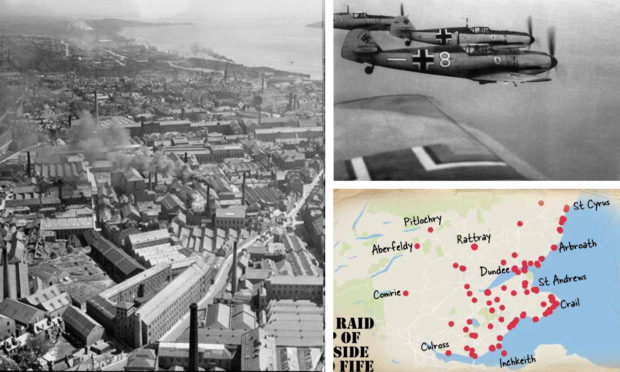
The most deadly attack in Courier country was on August 6 1942 in St Andrews when 11 people were killed and 23 were injured.

The next worst was on June 2 1941 where a naval mine in Buckhaven caused eight deaths and three injuries.

The last recorded incident was a night raid on May 22 1944 in Dundee, where nobody was injured.

More than 32,000 locations are included and users can zoom in on the official record for details of deaths and casualties.

The Bombing Britain air raid map uses wartime data from the National Archives to pinpoint all the locations struck by German bombs during the war.

It is free to use and is based on 6,500 daily reports compiled by wartime intelligence officers for the Ministry of Home Security and senior officials.

It was developed by Dr Laura Blomvall, a researcher from the Department of English and Related Literature at the University of York, whose work confirmed that the first place in Britain to be bombed was the Firth of Forth.

Dr Blomvall said: “This map offers an astonishing insight into the extent and scale of total war.

“Bombing Britain allows us to visualise how bomb strikes affected the entire country – not just London and the South East – as bombs were dropped from the Orkney Islands to Coventry, from Liverpool to the Scilly Isles and from Dover to Swansea.

“This unique research project shows how war was ‘no longer confined to the battlefield’.

“The normalisation of aerial warfare turned mainland Britain into a violent battlefield, and the term ‘home front’ was no longer figurative.”

Some 30,000 tonnes of bombs were dropped on the UK during the Blitz – an intense German bombing campaign targeting British industry and morale starting in September 1940 – killing over 40,000 people.

The Blitz began on 7 September 1940 – from when London was bombed 57 nights in a row. The last Luftwaffe raid took place on May 1944 – a month before D-Day.

Unexploded World War Two bombs continue to be discovered up and down the country, often causing schools or offices to be abandoned in a panic.

Dr George Hay, Military Historian at The National Archives, said: “The National Archives holds vast collections that tell the story of both the British and German strategic bombing campaigns of the Second World War.

“This interactive map makes use of the intelligence reports that followed German raids on the United Kingdom, and visually demonstrates the impact and reach of those attacks.

“This map will be a fantastic resource, not only for military and social historians, but for anyone interested in the impact of wartime air raids across the UK.”

Visit http://www.warstateandsociety.com/Bombing-Britain for more information.