Mearns flood defences touted as being equal to the worst of Scotland’s weather were field tested on Wednesday.
Stonehaven saw members of Aberdeenshire Council’s roads team install new defensive barriers at four locations in the town, as part of its £17 million anti-flood programme.
The local authority stated the first public demonstration was a chance to train frontline staff and check the condition of its equipment.
Flood management chief Gavin Penman said: “Today’s exercise to deploy the flood barriers in Stonehaven went very well indeed.
“All those involved found it useful and many lessons were learned, issues were raised and solutions were found.
“I have no doubt that the exercise has left us more able to respond to the threat of flooding in a timely manner, although naturally we hope to never have to put what we have learned into action.”
Storm Angus, the first-named storm of the season, hit the UK this week with gusts of up to 84mph battering the coast.
A council spokesman said: “If the barriers are deployed for real, as they were during Storm Frank at the start of the year, weather conditions are likely to be very poor and it’s also likely to be dark.”
In June, The Courier revealed the potential cost of clearing up flood damage across Angus and the Mearns has been estimated at more than £7 million each year.
More than 4,100 properties throughout the region are at risk of flooding, according to a Scottish-wide strategy aimed at safeguarding homes and businesses.
Angus Council has identified 4,700 properties in its Tay Estuary and Montrose Basin study, Perth and Kinross Council has pointed out that 230 Kirriemuir and Forfar homes are at risk in its River Tay local plan, and Aberdeenshire believes 1,100 homes and businesses are at risk in Stonehaven.
In response to Flood Risk Management (Scotland) Act 2009, the Tay Estuary and Montrose Basin plan was led by Angus Council on behalf of five neighbouring local authorities, along with Scottish Water, SEPA, Cairngorms National Park Authority, and Forestry Commission Scotland.
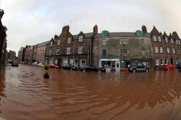
Approximately 60 residents, including elderly people living in sheltered housing, were evacuated from their Stonehaven properties on December 23 2012 after their homes were flooded.
A dedicated team of council staff worked into the night to remove boulders, mud and other debris strewn across the beachfront, the promenade, the harbour and in some instances, the town centre.
The council later unveiled plans for a £16 million scheme to prevent a repeat of the floods in November 2009 and 2012.
The proposals, which include the use of innovative “floating walls” which can be raised from hidden chambers when the River Carron is threatening to burst its banks, will protect homes and businesses in the lower part of the town against the threat of a one in 200 year flood event.