Calendar An icon of a desk calendar. Cancel An icon of a circle with a diagonal line across. Caret An icon of a block arrow pointing to the right. Email An icon of a paper envelope. Facebook An icon of the Facebook "f" mark. Google An icon of the Google "G" mark. Linked In An icon of the Linked In "in" mark. Logout An icon representing logout. Profile An icon that resembles human head and shoulders. Telephone An icon of a traditional telephone receiver. Tick An icon of a tick mark. Is Public An icon of a human eye and eyelashes. Is Not Public An icon of a human eye and eyelashes with a diagonal line through it. Pause Icon A two-lined pause icon for stopping interactions. Quote Mark A opening quote mark. Quote Mark A closing quote mark. Arrow An icon of an arrow. Folder An icon of a paper folder. Breaking An icon of an exclamation mark on a circular background. Camera An icon of a digital camera. Caret An icon of a caret arrow. Clock An icon of a clock face. Close An icon of the an X shape. Close Icon An icon used to represent where to interact to collapse or dismiss a component Comment An icon of a speech bubble. Comments An icon of a speech bubble, denoting user comments. Comments An icon of a speech bubble, denoting user comments. Ellipsis An icon of 3 horizontal dots. Envelope An icon of a paper envelope. Facebook An icon of a facebook f logo. Camera An icon of a digital camera. Home An icon of a house. Instagram An icon of the Instagram logo. LinkedIn An icon of the LinkedIn logo. Magnifying Glass An icon of a magnifying glass. Search Icon A magnifying glass icon that is used to represent the function of searching. Menu An icon of 3 horizontal lines. Hamburger Menu Icon An icon used to represent a collapsed menu. Next An icon of an arrow pointing to the right. Notice An explanation mark centred inside a circle. Previous An icon of an arrow pointing to the left. Rating An icon of a star. Tag An icon of a tag. Twitter An icon of the Twitter logo. Video Camera An icon of a video camera shape. Speech Bubble Icon A icon displaying a speech bubble WhatsApp An icon of the WhatsApp logo. Information An icon of an information logo. Plus A mathematical 'plus' symbol. Duration An icon indicating Time. Success Tick An icon of a green tick. Success Tick Timeout An icon of a greyed out success tick. Loading Spinner An icon of a loading spinner. Facebook Messenger An icon of the facebook messenger app logo. Facebook An icon of a facebook f logo. Facebook Messenger An icon of the Twitter app logo. LinkedIn An icon of the LinkedIn logo. WhatsApp Messenger An icon of the Whatsapp messenger app logo. Email An icon of an mail envelope. Copy link A decentered black square over a white square.

Jacobite and King James VI’s maps to illustrate talk on Dundee’s history

This 1678 map was created by Robert Edward and is entitled 'Angusia Provincia Scotiae sive' or 'The Shire of Angus'

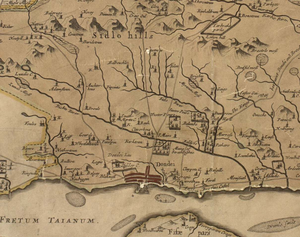
Maps of Dundee used by King James VI are among the historical charts which will be brought to the city for a special event this week.

Other maps on show at the annual Dundee Royal Scottish Geographical Society (RSGS) talk will include those used by the military in the wake of the Jacobite rebellion of 1745.

Chris Fleet, senior maps curator at the National Library of Scotland, said in addition to showing what historical Dundee looked like, maps can also reveal information about a period’s culture.

“Maps are a window to the position of Dundee at a particular point in time,” he said.

“On one level they show what is in what place, but we can also ask who made the map and why they made it.

“In the 17th century you find there are quite small scale maps that show an overview of an area to give an impression of the whole of Scotland.

“In the 18th century you see the growth of the port and construction of harbours.”

The talk will take a fascinating journey through selected maps of Dundee and its hinterland from the 16th century to the present day, based on the rich collections of the National Library of Scotland.

It will particularly look at the background to the maps, who made them and why, to explain something of their style and content.

Chris added: “It was only in 1750 that people started to use accurate instruments to record distances. It was not expected that people would try and accurately pin down features.”

The requirement for maps has also changed over time.

“For King James VI and I, maps were particularly used to integrate control of the whole state. It didn’t require so much of the detail, just knowing the position.

“In the 18th century there’s a real priority given to military maps made in relation to the Jacobites.”

The talk will also explore the recent work at the library to make these historic maps available online, and the use of technologies such as georeferencing and 3D overlays, to understand and visualise them better, with a brief look at the growing collections of born-digital mapping that the library is receiving.

Entry costs £2, and begins on Wednesday March 1 at 2.15pm in the D’Arcy Thompson Lecture Theatre at Dundee University.

Susan Mains, of the Dundee RSGS group, said: “The RSGS and the University of Dundee geography programme aim to engage with as wide an audience as possible in order to share the innovative and exciting work being done in relation to how we understand places, people and changes that take place over time.”