Kirkcaldy’s first half marathon for 27 years is a sell out, with more than 1,200 runners set to pound the streets on August 25.
Excitement is beginning to build ahead of the first event of its kind since 1992 and a series of road closures on the day has been announced.
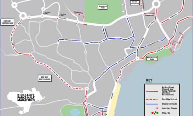
The race itself will start and finish in Beveridge Park, taking in two other parks, Dysart Harbour and Kirkcaldy Waterfront along the way, and a series of rolling road closures, lane closures and diversions will be put in place from 9.45am onwards on the day until around 2pm.
Councillor Neil Crooks, convener of the Kirkcaldy area committee, said it is shaping up to be a great event for the town.
“It’s fantastic to be welcoming a half marathon back into Kirkcaldy’s event calendar,” he said.
“It has really captured the interest of runners across Scotland and the route boasts some great landmarks.
“We look forward to welcoming a host of new visitors to the town including over 1,200 runners who will pass through all three public parks, historic Dysart and harbour and enjoy the amazing panoramic view from the waterfront across the Forth to the Lothians.
“Seeing the town for the first time in this way will hopefully whet their appetite to return for future half marathons and socially with their wider families.”
Registration for the event has now closed and all places have been allocated, although the event organisers are keen for spectators to come and support the runners along the route and in Beveridge Park.
Free and pay and display car parks will be in operation on the Sunday, with a full list of those available via www.fifedirect.org.uk/parking.
Access for emergency vehicles will always be maintained, although services such as the council’s Care at Home service, meals on wheels and bin collections may be slightly disrupted by the traffic restrictions that morning but aim to operate as close to normal a service as possible.
Organisers are also still on the hunt for volunteers to help the day go smoothly, and anyone interested should email volunteer.kphm@outlook.com for more information.
Rolling road closures and temporary parking / loading restrictions – note timings are approximate:
Abbotshall Road 9.45am – 2pm immediately outside the park and 9.45am – 10.45am to train station
Oriel Road northbound from Abbotshall Road to Bennochy Road 9.45am – 11am
Oriel Road, full closure between Bennochy Road and Torbain Road 9.45am – 11am
Chapel Level, lane closure westbound, no access from side roads 10am – 11am
Chapel Level, crossing at Crematorium 10.20am – 11.30am
Rosemount Avenue full closure between Dunnikier Way and Turnberry Drive (Crematorium access) 10am – 11.45am
Carberry Road (junctions closed 10.30am – 12:30pm
Midfield Road 10am – 12.30pm
Mitchelston Drive 10.30am – 12.30pm
Park Road from Dunnikier Way to Oswald Road 10.15am – 12.45pm
Oswald Road 10.15am – 12.45pm
Rosslyn Street from Gallatown Roundabout to Windmill Road 10.30am – 12.30pm
Windmill Road 10.30am – 12.30pm
Townhead, Dysart from Terrace Street to Dysart Road 10.15am – 12.30pm
Normand Road, Dysart from Windmill Road to Terrace Street – throughout Dysart 10.30am – 1.15pm
West Port, Dysart
Quality Street, Dysart
Cross Street, Dysart
Victoria Street, Dysart
Nether Street, Dysart
The Walk, Dysart
School Brae, Dysart from The Walk to High Street
Hot Pot Wynd, Dysart
Shore Road, Dysart from Hot Pot Wynd to Pan Ha’
Nether Street, Kirkcaldy westbound closure 10.30am – 1pm
The Path, westbound closure 10.30am – 1.30pm
High Street, westbound from (near The Granary) to Port Brae
Storm Road from Port Brae to opp Gas Wynd 11am – 1.30pm
Gas Wynd 10.45am – 2pm
Links Street from Hendrys Wynd to Milton Road 10.45 – 2pm
Milton Road 10.45am – 2pm
Abbotshall Rd 9.45am – 2pm
No waiting / no loading – note timings are approximate:
Midfield Road 10am – 12.30pm
Mitchelston Drive 10am – 12.30pm
Oswald Road 10.15am – 12.45pm
Milton Road 10.45am – 2pm
Townhead junction with West Port 10.15am – 12:30pm
West Port, Quality Street, Cross Street, Victoria Street, Nether Street, The Walk, School Brae Dysart 10.30am – 1.15pm
Windmill Rd – The Fairway to Normand Road / Townhead 10.15am – 12.30pm