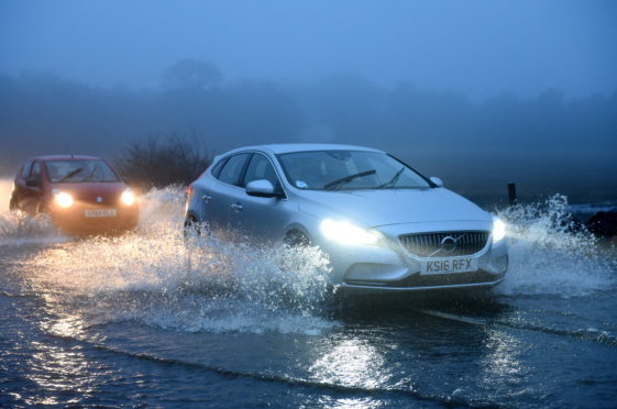
Eleven flood warnings have been issued for Tayside as wild weather batters the area.
The Scottish Environment Protection Agency (Sepa) said that the rivers Tummel, Isla, Earn, Lyon and Tay in Perthshire have surged as a result of “persistent heavy rainfall”.
The B846 Aberfeldy to Tummel Bridge road has been forced to close at Glengoulandie due to flooding.
Sepa has issued flood warnings for the following parts of Tayside:
- Upper Tay
- Pitlochry to Ballinluig
- Logierait to Jubilee Bridge
- Innerpeffray to Bridge of Earn
- Glen Lyon
- Crieff to Innerpeffray
- Carse of Lennoch to Lochlane
- Bridge of Ruthven to Leitfie
- Ballinluig to Logierait
- Aberbothrie
- The River Isla at Coupar Angus
In the Upper Tay warning, Sepa state that Aberfeldy’s golf course and caravan park are both at risk.
The organisation added that the B846 Weem to Aberfeldy road is at risk of flooding.
Met Office forecasts snow for parts of Tayside on general election polling day
The warning for Crieff to Innerpeffray states that the River Earn will peak at Crieff at about 5pm and at Innerpeffray at about 7pm. It adds that water levels will “remain high” overnight.
A Met Office yellow warning for wind was put in place across Tayside and Fife, effective from 5am until 5pm on Tuesday.
Met Office issues multiple local weather warnings with wind, rain, ice and snow forecast
It comes after traffic and weather warnings were put in force across Scotland as heavy wind and rain swept across the country.
There are restrictions in place on the Tay Road and Forth Road bridges as well as the Queensferry Crossing.
https://www.facebook.com/TaysidePoliceDivision/posts/2800948959957484?__xts__%5B0%5D=68.ARAwzUr1VqGjwyf_ylwwcKNRdsJz_2JImTfJBTmbEqt2JWDxhHaSW9jMOElFvh2kTRk0FZ3044WkyCm3jZC7VGnpPAjgpQiaISpFF5z8Oyf04SeabxrF-vJEav30NRGjh9xuk-UYfBCXeBeuU2UU8AW5N88Ik5vS5LEvajFACAHvQn1Hcq_2renWAAx8ucGjHURyPIvMtf9eafQMLaAGM7ZyZyEpstKI4y4LPN_PO91QzCDW-gsWrJWuxQ8sIBbzlMi3O8Sji1TKZ8kh0OWw0PX6-6YrCuCt_-zc3DKqo6cpmLA2slNgLiWVPtkWrAan48DpttoYgxbPfIURVLRwCg&__tn__=-R
Flooding is also said to be affecting the M9 between Bridge of Allan and Stirling.
On the other side of the Keir Roundabout, Bear Scotland crews attended the A9 at Greenloaning at around 11am yesterday caused by the heavy rain.
The water did not subside until around 12.30pm according to the trunk road managers.
A message from the police, posted on the Traffic Scotland website, reads: “Police Scotland is advising that the Met Office has issued an alert and that conditions may be hazardous due to high winds and extra caution should be exercised.
“If you are driving a vehicle which may be vulnerable to being blown over in such conditions along exposed routes including bridges, please exercise additional caution and plan your route to avoid exposed areas or consider cancelling your journey until conditions improve.
“Previous incidents have clearly shown the dangers of driving vehicles vulnerable to being blown over in high wind conditions and the subsequent danger created for other road users, emergency services and recovery operatives where incidents have occurred due to drivers ignoring warnings.”