Calendar An icon of a desk calendar. Cancel An icon of a circle with a diagonal line across. Caret An icon of a block arrow pointing to the right. Email An icon of a paper envelope. Facebook An icon of the Facebook "f" mark. Google An icon of the Google "G" mark. Linked In An icon of the Linked In "in" mark. Logout An icon representing logout. Profile An icon that resembles human head and shoulders. Telephone An icon of a traditional telephone receiver. Tick An icon of a tick mark. Is Public An icon of a human eye and eyelashes. Is Not Public An icon of a human eye and eyelashes with a diagonal line through it. Pause Icon A two-lined pause icon for stopping interactions. Quote Mark A opening quote mark. Quote Mark A closing quote mark. Arrow An icon of an arrow. Folder An icon of a paper folder. Breaking An icon of an exclamation mark on a circular background. Camera An icon of a digital camera. Caret An icon of a caret arrow. Clock An icon of a clock face. Close An icon of the an X shape. Close Icon An icon used to represent where to interact to collapse or dismiss a component Comment An icon of a speech bubble. Comments An icon of a speech bubble, denoting user comments. Comments An icon of a speech bubble, denoting user comments. Ellipsis An icon of 3 horizontal dots. Envelope An icon of a paper envelope. Facebook An icon of a facebook f logo. Camera An icon of a digital camera. Home An icon of a house. Instagram An icon of the Instagram logo. LinkedIn An icon of the LinkedIn logo. Magnifying Glass An icon of a magnifying glass. Search Icon A magnifying glass icon that is used to represent the function of searching. Menu An icon of 3 horizontal lines. Hamburger Menu Icon An icon used to represent a collapsed menu. Next An icon of an arrow pointing to the right. Notice An explanation mark centred inside a circle. Previous An icon of an arrow pointing to the left. Rating An icon of a star. Tag An icon of a tag. Twitter An icon of the Twitter logo. Video Camera An icon of a video camera shape. Speech Bubble Icon A icon displaying a speech bubble WhatsApp An icon of the WhatsApp logo. Information An icon of an information logo. Plus A mathematical 'plus' symbol. Duration An icon indicating Time. Success Tick An icon of a green tick. Success Tick Timeout An icon of a greyed out success tick. Loading Spinner An icon of a loading spinner. Facebook Messenger An icon of the facebook messenger app logo. Facebook An icon of a facebook f logo. Facebook Messenger An icon of the Twitter app logo. LinkedIn An icon of the LinkedIn logo. WhatsApp Messenger An icon of the Whatsapp messenger app logo. Email An icon of an mail envelope. Copy link A decentered black square over a white square.

Laser drones are helping tackle tree disease in Highland Perthshire

Drummond Hill, as viewed by laser-mounted drones

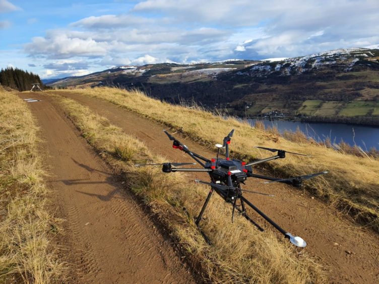
Laser-mounted drones are helping battle a rare tree disease in highland Perthshire.

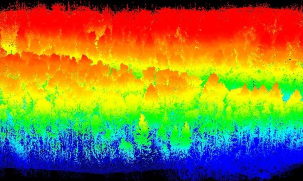
The high-flying devices use thermal imaging technology to assess the lay of the land beneath forest canopies.

They were brought in by Forestry and Land Scotland (FLS) to plan woodland management in the face of a “devastating” plant pathogen.

A drone being used to fight tree disease in Perthshire

The LIDAR (Light Detection and Ranging) cameras are being used to plan the felling of trees affected by Phytopthora ramorum, which is steadily making its way towards Drummond Hill above Kenmore and Loch Tay.

The drones gather very precise measurements of both the canopy and the forest floor by bouncing lasers from the drone to the surface and back again.

Robin Almond, the FLS officer who looks after the woodland said: “This is a really terrible disease that devastates larch trees and if it were to reach the larch on Drummond Hill, the scenic beauty and character of the place would be seriously affected.”

He said: “There is no cure for the disease and the only tool at our disposal for tackling it is to fell trees already affected and to create a buffer zone around healthy trees that might keep the disease at bay.

“This is something we have to start planning for Drummond Hill, but we want to minimise the felling if we can and also carry it out with as little impact as possible on the more sensitive habitat areas on the hill.

“LIDAR helps us map the forest and the ground it sits on to a high resolution, which lets us plan this down to some very specific detail.”

Different felling techniques (for bigger, smaller or more sensitive areas) require different kinds of machinery, so mapping potential access routes helps the team to assess what technique is most appropriate for any given part of the woodland.

Images produced by the drones are deemed more effective than an on-the-ground inspection. They can also better identify surface hazards like crags or large boulders.

Once felling has been completed, FLS intends to plant a mixture of tree species.