Calendar An icon of a desk calendar. Cancel An icon of a circle with a diagonal line across. Caret An icon of a block arrow pointing to the right. Email An icon of a paper envelope. Facebook An icon of the Facebook "f" mark. Google An icon of the Google "G" mark. Linked In An icon of the Linked In "in" mark. Logout An icon representing logout. Profile An icon that resembles human head and shoulders. Telephone An icon of a traditional telephone receiver. Tick An icon of a tick mark. Is Public An icon of a human eye and eyelashes. Is Not Public An icon of a human eye and eyelashes with a diagonal line through it. Pause Icon A two-lined pause icon for stopping interactions. Quote Mark A opening quote mark. Quote Mark A closing quote mark. Arrow An icon of an arrow. Folder An icon of a paper folder. Breaking An icon of an exclamation mark on a circular background. Camera An icon of a digital camera. Caret An icon of a caret arrow. Clock An icon of a clock face. Close An icon of the an X shape. Close Icon An icon used to represent where to interact to collapse or dismiss a component Comment An icon of a speech bubble. Comments An icon of a speech bubble, denoting user comments. Comments An icon of a speech bubble, denoting user comments. Ellipsis An icon of 3 horizontal dots. Envelope An icon of a paper envelope. Facebook An icon of a facebook f logo. Camera An icon of a digital camera. Home An icon of a house. Instagram An icon of the Instagram logo. LinkedIn An icon of the LinkedIn logo. Magnifying Glass An icon of a magnifying glass. Search Icon A magnifying glass icon that is used to represent the function of searching. Menu An icon of 3 horizontal lines. Hamburger Menu Icon An icon used to represent a collapsed menu. Next An icon of an arrow pointing to the right. Notice An explanation mark centred inside a circle. Previous An icon of an arrow pointing to the left. Rating An icon of a star. Tag An icon of a tag. Twitter An icon of the Twitter logo. Video Camera An icon of a video camera shape. Speech Bubble Icon A icon displaying a speech bubble WhatsApp An icon of the WhatsApp logo. Information An icon of an information logo. Plus A mathematical 'plus' symbol. Duration An icon indicating Time. Success Tick An icon of a green tick. Success Tick Timeout An icon of a greyed out success tick. Loading Spinner An icon of a loading spinner. Facebook Messenger An icon of the facebook messenger app logo. Facebook An icon of a facebook f logo. Facebook Messenger An icon of the Twitter app logo. LinkedIn An icon of the LinkedIn logo. WhatsApp Messenger An icon of the Whatsapp messenger app logo. Email An icon of an mail envelope. Copy link A decentered black square over a white square.

Map predicts ‘severe’ thunder and possibly a tornado in Tayside and Fife tonight

A weather forecaster has released a map showing where thunder and lightning is predicted to hit this evening – with Tayside and Fife under a ‘severe’ threat.

Convective Weather says all of England and Scotland and parts of Wales and Ireland are at risk of thunder this evening.

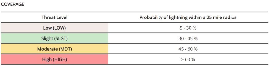
The highest chance of thunder and lightning – more than 60% – is in a splodge of central Scotland including Perth, Pitlochry, Blairgowrie, Crieff, Comrie, Kinross, Kirkcaldy and Dunfermline. It also covers Stirling, Edinburgh and Dumfries in south-west Scotland.

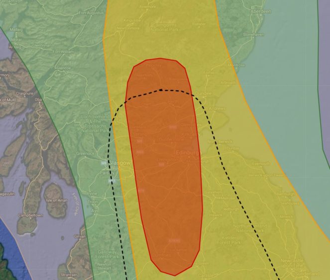
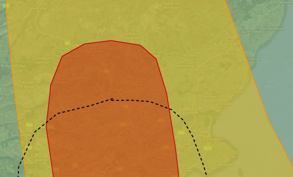
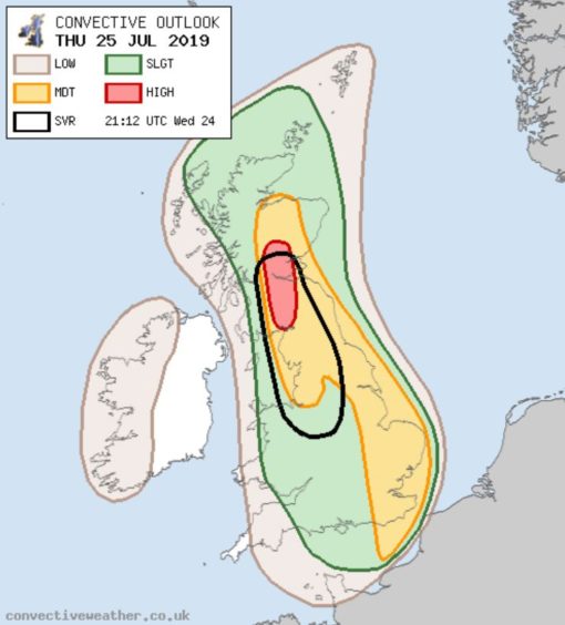
A threat for severe thunderstorms, covered by the black line, is in force for all of Perthshire south of Bankfoot and all of Fife west of Cupar.

Criteria for a severe thunderstorm is:

  • 25mm or more precipitation in 3 hours or less
  • Hail greater than 2.0cm in diameter
  • Wind gusts greater than 55mph
  • Tornadoes
Dave Barrett captured a rare double tornado in the hills north of Kirriemuir in May.

The forecaster added: “We classify a severe thunderstorm as one that poses a significant threat to life and/or property.

“This does not necessarily mean severe convective weather will occur in all parts of the highlighted area, but it indicates the potential for such an occurrence, even if quite localised.”

Convective Weather says “a rather rare setup is expected to develop across the British Isles on Thursday.”

The forecaster added: “A negatively-tilted upper trough will be located to the west over the Atlantic, placing the British Isles on its forward side with a shortwave rounding its base and lifting northwards during Thursday evening.

“Thunderstorms are expected to increase in coverage as they continue to drift northwards, with the best multi-model agreement by the time they reach southern Scotland – hence the inclusion of a high risk area.

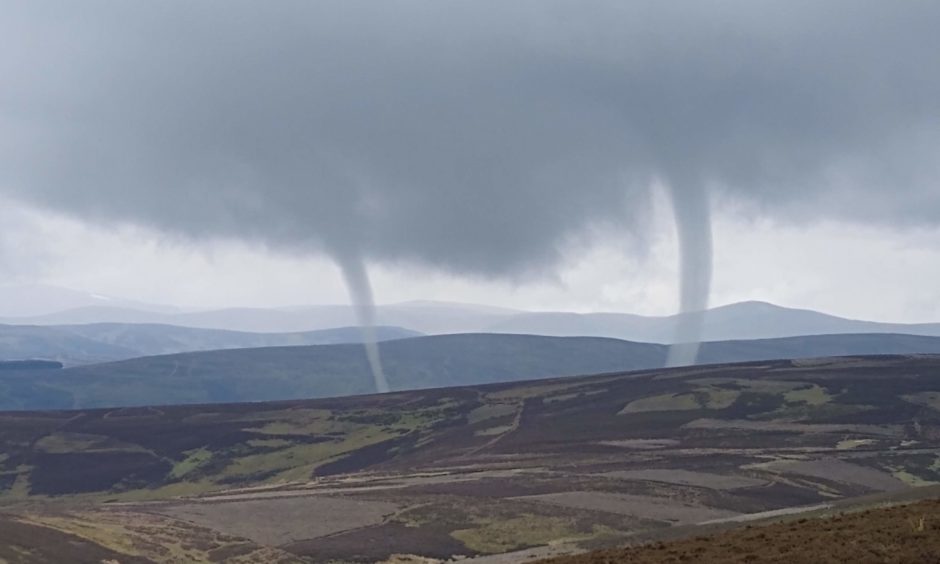
“Strong deep layer shear, with some backing at the low-levels, suggests a couple of supercells will be possible, capable of producing very frequent lightning, large hail 3-4cm in diameter and, if storms can remain surface-based, the risk of a tornado or two.

“A SVR has been introduced to cover the threat of large hail, flash flooding and perhaps a tornado.”

A moderate alert of thunder and lightning is predicted for the remaining parts of Courier Country, with a probability level of 45%-60%.

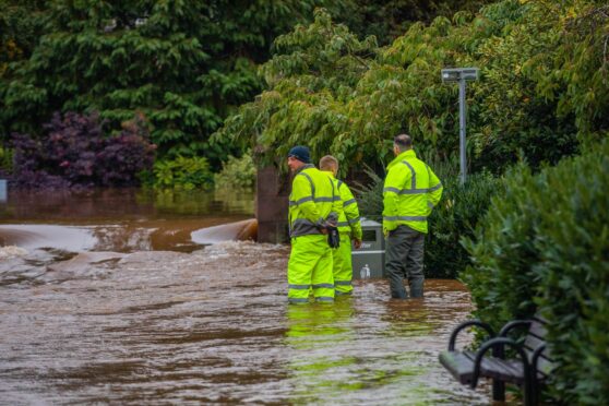
The Met Office has already warned of “sudden flooding” and more thunderstorms in Dundee, Angus, Fife and parts of Perthshire.

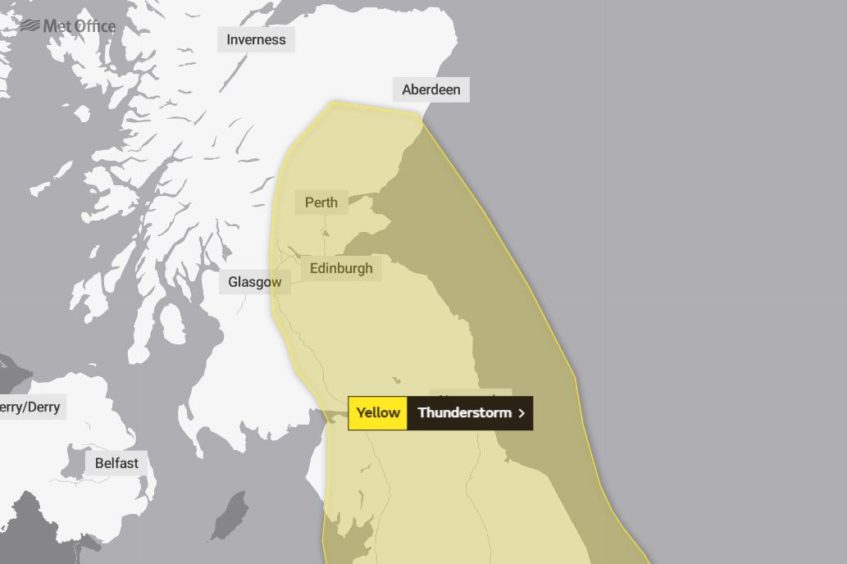
The forecaster has issued a yellow warning for thunderstorms across most of Courier Country, valid from 3pm Thursday until 4am Friday.

The Scottish Environment Protection Agency (Sepa) has also issued flood alerts for Dundee, Angus, Fife, and Perth and Kinross valid from Thursday into Friday.

The warning says that potentially record-breaking temperatures on Thursday could sparking scattered thunderstorms later in the day, continuing overnight.

Met Office warns of ‘sudden flooding’ and more thunderstorms in Dundee, Angus, Fife and Perthshire