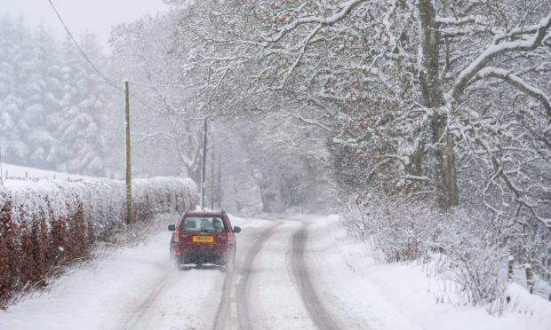
Widespread snow is due to hit Tayside and Fife as the UK prepares for the arrival of Storm Christoph.
Forecasters are warning locals to be braced for more than 1ft of the white stuff in some areas as a fresh spell of wild weather sweeps across the country.
Winds of up to 60mph could batter the coast with “blizzard conditions” possible.
The UK is due to be hit by heavy rain, wind and wintry showers starting from Wednesday as Storm Christoph makes its presence felt.
A Met Office yellow warning for snow will be in place throughout all of Thursday. It covers Angus, Dundee, Perth and Kinross, and much of Fife.
Snowfall is expected even at the lowest levels, including along the coast, as the freezing air moves into Scotland from the north-east on Thursday.
The Met Office snow warning for Tayside and Fife reads: “An area of rain associated with Storm Christoph will push in from the north-east, turning readily to snow away from coasts and at even modest elevation.
“Snow accumulations of 5-10cm (1.9in-3.9in) are possible in places at low levels whilst 10-15cm (3.9in-5.9in) is likely above around 200m (656ft) with perhaps 30-40cm (11.8in-15.7in) above 400m (1,312ft).
“Along north facing coasts and particularly north Aberdeenshire the precipitation will stay as rain with widely 20-30mm (0.8in-1.18in) of rain falling during the period and a few sites perhaps seeing around 50mm.
“In addition strong winds will develop through Thursday with gusts of 60mph along the north facing coasts perhaps an additional hazard.
“These stronger winds will also lead to very poor conditions where snow falls with blizzard conditions at times over higher ground. Inland from the coast with wet snow likely this may lead to icing on infrastructure, such as power lines.”
WHITE OUT: Drivers stuck and spate of A9 accidents as Perthshire hit by major snowfall
Series of hazards facing UK in coming days
Met Office spokesman Oli Claydon said that rain is “initially” the main concern but the picture will change as low pressure could introduce colder air.
He explained: “As we go through the week and the low pressure that is bringing these fronts of rainfall that are persistent and heavy over the next few days.
“As that low pressure moves east and out into the North Sea, the winds will become a thing really later in the week.
“Also as the low pressure moves away it pulls down a north-westerly airflow which brings much colder air across the UK again which then presents a further risk of snow.”
Mr Claydon described the situation as “a timeline of different hazards as we go through the week but the first hazard is certainly of rain and that’s reflected in the warnings at the moment”.
An amber warning for rain was in place in parts of England on Tuesday morning, alongside less serious yellow ones for rain across Wales, Northern Ireland, northern England and southern Scotland.
Yellow and amber warnings for rain will also cover much of England from Wednesday into Thursday.