Calendar An icon of a desk calendar. Cancel An icon of a circle with a diagonal line across. Caret An icon of a block arrow pointing to the right. Email An icon of a paper envelope. Facebook An icon of the Facebook "f" mark. Google An icon of the Google "G" mark. Linked In An icon of the Linked In "in" mark. Logout An icon representing logout. Profile An icon that resembles human head and shoulders. Telephone An icon of a traditional telephone receiver. Tick An icon of a tick mark. Is Public An icon of a human eye and eyelashes. Is Not Public An icon of a human eye and eyelashes with a diagonal line through it. Pause Icon A two-lined pause icon for stopping interactions. Quote Mark A opening quote mark. Quote Mark A closing quote mark. Arrow An icon of an arrow. Folder An icon of a paper folder. Breaking An icon of an exclamation mark on a circular background. Camera An icon of a digital camera. Caret An icon of a caret arrow. Clock An icon of a clock face. Close An icon of the an X shape. Close Icon An icon used to represent where to interact to collapse or dismiss a component Comment An icon of a speech bubble. Comments An icon of a speech bubble, denoting user comments. Comments An icon of a speech bubble, denoting user comments. Ellipsis An icon of 3 horizontal dots. Envelope An icon of a paper envelope. Facebook An icon of a facebook f logo. Camera An icon of a digital camera. Home An icon of a house. Instagram An icon of the Instagram logo. LinkedIn An icon of the LinkedIn logo. Magnifying Glass An icon of a magnifying glass. Search Icon A magnifying glass icon that is used to represent the function of searching. Menu An icon of 3 horizontal lines. Hamburger Menu Icon An icon used to represent a collapsed menu. Next An icon of an arrow pointing to the right. Notice An explanation mark centred inside a circle. Previous An icon of an arrow pointing to the left. Rating An icon of a star. Tag An icon of a tag. Twitter An icon of the Twitter logo. Video Camera An icon of a video camera shape. Speech Bubble Icon A icon displaying a speech bubble WhatsApp An icon of the WhatsApp logo. Information An icon of an information logo. Plus A mathematical 'plus' symbol. Duration An icon indicating Time. Success Tick An icon of a green tick. Success Tick Timeout An icon of a greyed out success tick. Loading Spinner An icon of a loading spinner. Facebook Messenger An icon of the facebook messenger app logo. Facebook An icon of a facebook f logo. Facebook Messenger An icon of the Twitter app logo. LinkedIn An icon of the LinkedIn logo. WhatsApp Messenger An icon of the Whatsapp messenger app logo. Email An icon of an mail envelope. Copy link A decentered black square over a white square.

Turbulent week of weather with unseasonable heat predicted…before 80mph storms batter Scotland

Stormy weather, and hot conditions, are forecast for both the local area and wider Scotland.

A week of turbulent weather across Tayside and Fife could end with 80mph storms – but not before locals enjoy a day of unseasonably high temperatures.

A week that has already brought a downpour and flood alerts to the area may end with travel chaos and power cuts with a Met Office yellow warning coming into force in the region between 5am and 9pm on Friday.

A yellow warning for “heavy rain” came into effect across Tayside and Fife on Monday morning and is expected to endure until Tuesday evening.

A forecast for “persistent and heavy rain” also prompted a flood alert from the Scottish Environment Protection Agency (Sepa) for the Tayside region.

However forecasters say the mercury could soar to 20C in the local area on Wednesday before the weather takes another turn for the worse from Thursday into Friday.

According to Met Office records, the average local temperature for the second week of October is 13C. For the whole of October the Scottish figure is 11C.

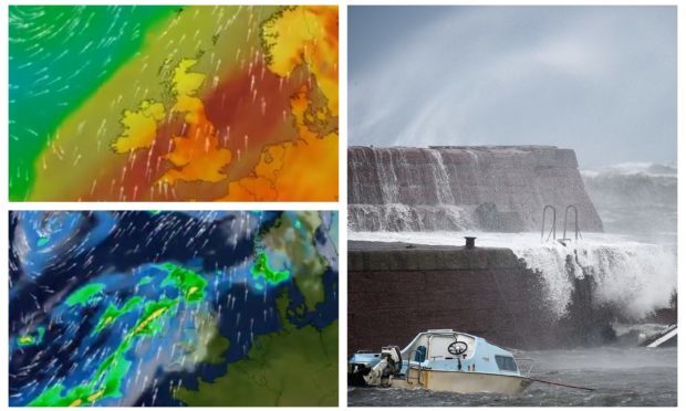
Met Office meteorologist Sophie Yeomans said: “At the moment we have a weather front bringing quite a lot of heavy rainfall. Some parts of western Scotland could see 100mm (3.9in) or so, potentially far more, into Tuesday.

“It will be much better over the central and eastern end of Scotland. Through Tuesday we’ll see a few sunny breaks.

“Wednesday is fine and dry conditions, and the temperatures could see the high-teens or so. I think as we head into Wednesday it might feel quite warm. I’d expect 18C, 19C or 20C.”

The poor conditions later in the week are being caused by a weather system moving in from the Atlantic, but are not linked to Storm Leslie.

The Met Office warning for Friday states there is a “small chance of injuries and danger to life” as a result of flying debris or large waves in coastal regions, as well as damage to buildings.

The conditions could also cause delays to road, rail, air and ferry travel; as well as route and bridge closures.

Ms Yeomans added: “On Thursday we’ll see a bit more unsettled weather. It will turn wet and windy as the weather front moves in but on Friday we’ll see a stronger weather system move through. That will be bringing some heavy portions of rain but also really strong winds.

“The gales may be severe gales. That will be affecting all parts of Scotland in terms of the wind.

“At the moment, as the warning suggests, we’re going to be seeing (gusts) upwards of 60mph-70mph, possibly 80mph around really exposed areas.

“I think anywhere in the exposed areas could see that, anywhere exposed to the wind.

“The main brunt of the storm will pass through on the Friday.

“Into Saturday there will be more in the way of heavy rainfall coming through. The winds will start to ease off late on Friday into Saturday.

“Friday’s is a heads up warning. It is coming in from the Atlantic. It’s a weather system that’s developing over in the west, off the coast of America and Canada. It is not Storm Leslie, it’s a separate system.”