Mount Battock, Glen Esk, Angus
The most easterly of the Corbetts and one of just three in Angus, Mount Battock is the highest point on a long ridge of rolling summits above Glen Esk that stretch all the way along to Clachnaben and Glen Dye.
There is a good choice of approach routes and despite the distances involved the walking is easy, mostly on a network of estate tracks which seem to multiply with every visit.
Off track, the terrain is featureless and this high, open moorland can feel very exposed in inclement weather with little in the way of shelter.
There was no such concern on my latest foray, a bluebird day with the sun splitting the sky. On a morning like this, the biggest question was whether there would be any spaces available in the small car park at Millden. This is located beside a phone box off a minor road to the right just after crossing the stone bridge over the Water of Turret. Even at this early hour, there was just one spot left.
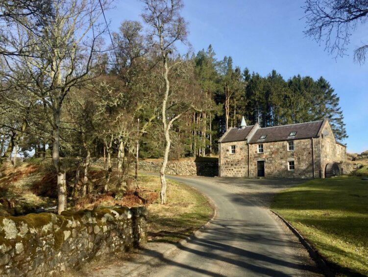
The tarmac road goes north alongside the water to an old stone mill complete with waterwheel then swings to the left, passing the cottage at Mill of Aucheen. Just beyond, at a junction, keep left, continuing on past the farm buildings at Blackcraigs and ignoring the track branch heading right to reach a metal gate between two small plantations.
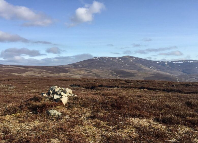
The track rises steadily but gently towards the first summit of the day, Mount Een, with fine views north-east to distant Mount Battock. At one point a fine pencil cairn is passed, and there are a few grouse butts lining the way. In spring and summer, the air is filled with the piercing calls of lapwings.
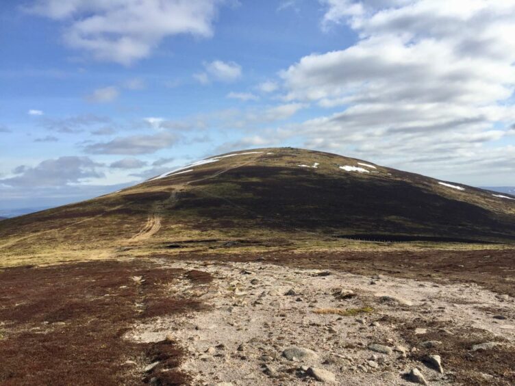
From the small pile of stones marking the top of Mount Een, the track takes a small kink before doubling back to the onward march, dipping slightly then rising again to another small cairn on Bennygray. Shortly after leaving this top, the track takes a right turn east towards Wester Cairn before the final rise to Mount Battock.
There are several suggestions as to the origin of the hill’s name. One is said derive from the Gaelic Monadh Beathach, meaning hill of the birches, another from Monadh Badach, the tufted hill, a hint at rough walking over heather and hummocks. The latter definitely feels more appropriate these days: any tree cover may be long gone, but the hillsides still provide rough walking.
A third option is chump hill, battock coming from an old word for chump, an 18th Century term for the thick end of a lump of wood. This would likely refer to the shape of the hill from certain angles.
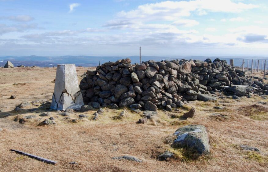
There’s no chance of mistaking this summit, even in thick mist: there’s a massive sprawling shelter cairn with a trig pillar in attendance, and a fence runs across the top of the hill. All the usual suspects are now lined up, from Mount Keen to Driesh, and far off to the east is the unmistakable profile of the huge iconic tor of Clachnaben.
Unless you are tempted by a hugely extended day, it’s time to head back. Start by crossing the fence by a wooden stile and follow the fence line south on a rough and muddy path, steeply at times, down to a boggy col and a hop across to a gate which gives access to Hill of Saughs and an improving track.
This track leaves the boundary line and swings right, rising again to Hill of Turret before dropping to a junction where a sharp right turn should be made to reach another track running alongside the Water of Turret.
The track eventually drops right to cross the stream and runs south along the treeline before swinging round past Muir Cottage and then rejoining the inward route at the old mill.
ROUTE
1. Head north-west up minor road from parking, passing stone mill on right then swinging left to house at Mill of Aucheen.
2. Continue to Blackcraigs where main track goes between two small plantations through metal gate, ignore branch going left, continue climbing steadily towards Mount Een.
3. From this cairned top, the track takes a small kink (left, then sharp right) before heading north-east again to next summit, Bennygray.
4. Track drops slightly to wide col then turns east to pass over summit of Wester Cairn before making final gentle rise to huge cairn and trig pillar on Mount Battock.
5. Drop south from summit (stile) steeply by fence to boggy col, then through gate, picking up more substantial track on Hill of Saughs.
6. Keep following track downhill to next top, Hill of Turret.
7. Beyond this, the track becomes grassier. At next junction, take right branch and follow down to cross Burn of Turret.
8. Follow track south with trees on your left until it turns west to pass in front of Muir Cottage, and then continue down past the stone mill to parking.
INFORMATION
Distance: 13.5km/8miles
Ascent: 726m/2380ft
Time: 4-6 hours
Grading: Steady ascents mainly on estate tracks, suitable for well-equipped walkers with reasonable level of fitness and navigation skills. Some rougher ground and boggy sections, good footwear recommended. Dogs under close control due to farm livestock and ground nesting birds.
Start/finish: Small parking area at Millden in Glen Esk (Grid ref: NO 540789), minor road on right after bridge.
Map: Ordnance Survey 1:50,000 Landranger Map 44 (Ballater & Glen Clova); Ordnance Survey 1:25,000 Explorer sheet 54.
Tourist Information: VisitScotland, Dundee iCentre, 16 City Square, Dundee DD1 3BG (Tel 01382 527527)
Public transport: None.