The water and wetlands of the Royal Society for the Protection of Birds (RSPB) reserve at Loch of Kinnordy, near Kirriemuir, has long attracted creatures of the winged variety.
In more recent times, however, the loch has become home to a family of beavers with evidence aplenty of their activities.
The reserve has a short trail linking a roadside car park with a trio of hides strung out along the southern shoreline but, for those seeking a longer outing, it can be incorporated into a hike through fields and farmland lying to the west of the Angus town.
With this in mind, I began in the heart of the historic burgh, at Bellies Brae, from where a path tracks the youthful Gairie Burn upstream to Kirrie Den. The flow is a fitting companion, for the burn rises at Loch of Kinnordy and it would remain by my side on my journey there.
Path and stream – spanned by a series of small bridges – run hand in hand through the den’s parkland and play areas, curving right beyond the bandstand to enter a dark, wooded gorge where the way rises above a cascade of white water and the Cuttle Well, a natural spring, to meet Lochmill Road.
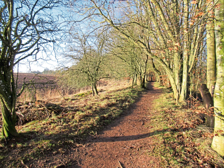
Re-joining the Gairie Burn on the other side of the asphalt, the trail curves round the edge of a field before striding through a lovely, sheltered band of mature woodland to enter the RSPB reserve.
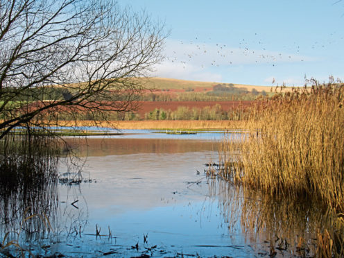
Flanked by farmland, Loch of Kinnordy is a shallow stretch of water bounded by pools, wetlands, marsh and swamp and attracts both wildfowl and wildlife, swans, ducks, otters and red squirrels among its residents.
There are beavers here too, a native animal that crept back into Scotland after an absence of over 500 years, colonising many of the tributaries of the River Tay, Kinnordy among them.
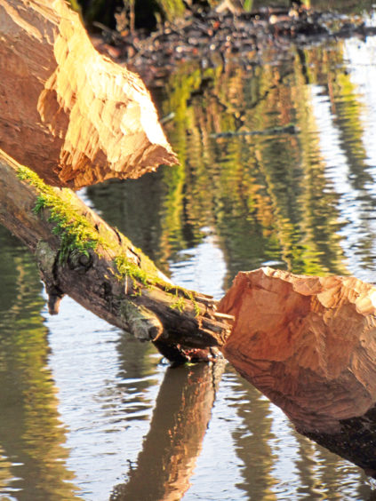
While the rodent is not an easy spot – beavers are most active around dawn and dusk – evidence of its industrious nature – gnawed tree stumps, trails and dams – are clear to see in the marshy wetlands at the eastern end of the loch.
Their occupation has not been without problems and the path crosses a sluice where a ‘beaver deceiver’ has been installed. It is a device that allows the creatures to construct dams while controlling water levels and minimising the risk of neighbouring farmland and footpaths flooding.
A little further on, the reserve’s well stocked bird feeders are a good place to catch sight of another mammal, the red squirrel.
Country roads led me west from Kinnordy’s car park to Lochside Cottage then south through farmland, up and over the hill to the village of Westmuir.
Here I turned east and, enjoying an extensive vista south across Strathmore towards the distant Sidlaw Hills, walked back to Kirriemuir, between fields and past a farm at Plovermuir and steading at North Mains of Logie.
Glamis Road (A928) offers a short cut north, back to Bellies Brae, but I continued east to the neighbouring hamlet of Maryton where, at the far end of the main street, I branched left to Whitelums.
Climbing towards the farm, the track curves left, rising between fields above before descending into Kirriemuir where, by the old Gairie Works, built as a linen mill in 1873 and now housing a textile firm, Gairie Burn was waiting to guide me back to Bellies Brae.
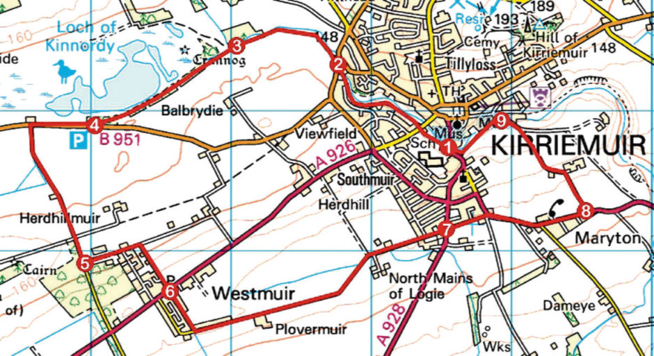
ROUTE
1. Cross Gairie Burn and follow path upstream and onward through Kirrie Den. Where den narrows, ascend to bridge, go left and, at next junction, go right then left to Lochmill Road.
2. Cross Lochmill Road, go through gate and follow path (signed Nature Reserve).
3. Where path forks, go left to reserve car park.
4. Go right for 450m along B951 then left (signed Westmuir) for 1km along minor road.
5. Turn left (signed Westmuir) along track then go right at next signed junction, descending to Westmuir.
6. Cross A926, continue ahead (signed Kirriemuir) then, in 300m, swing left and follow track 2km east to Kirriemuir.
7. Cross A928, continue ahead along Beechwood Place to A926. Bear right and follow A926 through Maryton.
8. Turn left, ascending farm track to Whitelums. Branch left, ascending track past house to Kirriemuir.
9. Go left, descending to Gairie Works. Continue ahead (signed Kirrie Den), crossing Gairie Burn, and follow road then path by stream to Bellies Brae.
INFO
Distance: 10.8km/6¾ miles
Ascent: 120m/400ft
Time: 3 hours
Grading: Moderate low-level route following good paths, minor roads and pavements in and around Kirriemuir. Stout footwear recommended. Keep dogs under close control within RSPB reserve
Start/finish: Bellies Brae car park, Bellies Brae, Kirriemuir (Grid ref: NO 385537). Pay and display (£1 per hour)
Map: Ordnance Survey 1:50,000 Landranger sheet 54; Ordnance Survey 1:25,000 Explorer sheet 381
Tourist Information: Dundee iCentre, 16 City Square, Dundee DD1 3BG (Tel 01382 527527)
Public transport: Stagecoach bus service 20 links Kirriemuir with Dundee, Forfar and other parts of Angus