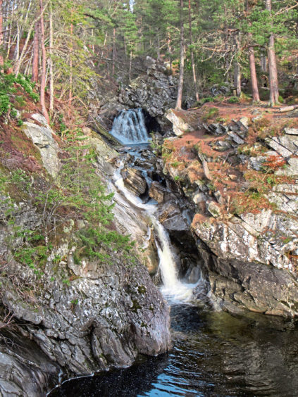
Whatever time of year you visit, whatever the weather, the cascades of white water tumbling down through the narrow rocky ravine, coursing under quaint old stone bridges, at Falls of Bruar, near Blair Atholl, never fail to impress.
The climb from the car park to the upper falls and back only takes around an hour, but you can spend a lot more time here, photographing the falls or just sitting by the water admiring the remarkable beauty of nature.
The last time I visited was back in the autumn of 2017, the lower falls preamble to a longer outing exploring the remoter reaches of the Bruar Water as it meanders through the hills and across the moorland of the Forest of Atholl before making its final dramatic descent to the River Garry.
Driving the A9 after a recent trip to the northern Highlands, with legs in need of a good stretch, I pulled off the carriageway for a break at Bruar, a return to the falls long overdue. And, as I discovered, much had changed since I was last here.
Extensive car parking by the House of Bruar shopping centre serves the falls too and, from Bruar Bridge, at the eastern end of the complex, the trail follows Bruar Water upstream.
The languid flow here offers little clue to the drama that awaits further up the valley but, pass through a wee tunnel burrowing under the railway, and the majesty of the river is soon revealed, the path rising above a deep defile, past an elevated viewpoint, to the first of two bridges.
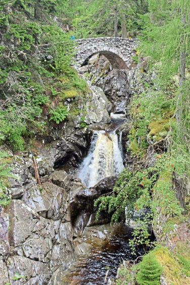
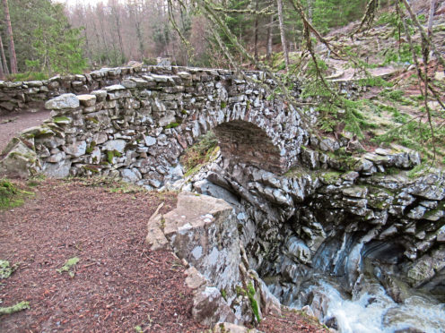
Spanning the lower falls, the rough stone arch and an adjacent viewing platform were constructed in the late 18th century by John Murray, 4th Duke of Atholl, and formed part of a ‘wild garden’ flanking the falls.
The trail today takes the duke’s original route and walkers follow in the footsteps of notable early visitors, Queen Victoria, artist William Turner and poets William Wordsworth and Robert Burns among them.
It was Burns who urged the duke to plant trees, penning The Humble Petition of Bruar Water in 1787. As a footnote, he added: ‘Bruar Falls are exceedingly picturesque and beautiful, but their effect is much impaired by the want of trees and shrubs’.
The slopes were duly wooded, albeit after his death, and, while trees have fallen or been cut down and replanted over the years, a more recent wholesale clearance would doubtless have prompted Burns, were he still with us, to put pen to paper once again.
Large swathes of larch bordering the gorge were brought down at the end of 2017, the estate forced to axe them in a bid to stem the spread of a particularly virulent disease affecting the species.
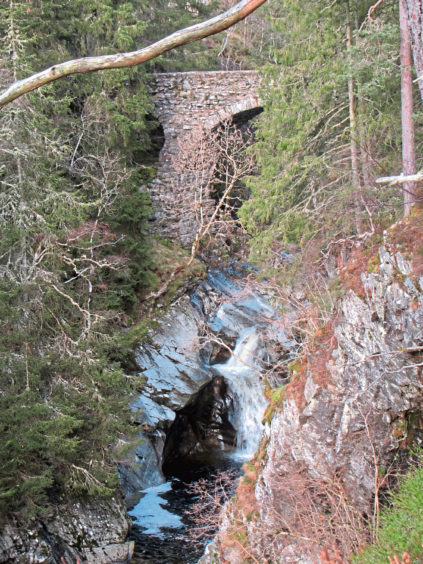
Unsurprisingly, the landscape of the falls has changed and, while pines, firs and spruces still grow tall down in the gorge and saplings gain a foothold above, the aspect is more open, and, as I climbed the rough trail to Upper Bridge, I discovered new views west over Glen Garry towards distant Schiehallion.
Above the bridge, at a secluded picnic area, the way turns south, a smoother path descending through woodland, returning to the lower bridge.
The landscape may be altered but the falls – the real stars of the show – were every bit as impressive as I remembered.
ROUTE
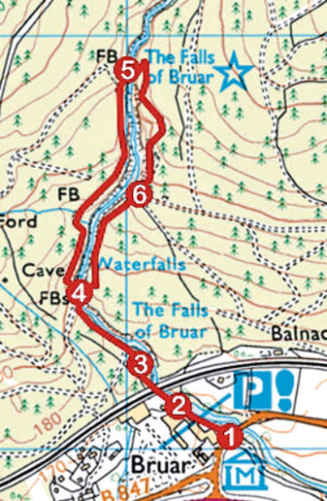
1. Exit car park on to B8097, cross and, bearing to right of shopping complex, follow gravel track (signed Falls of Bruar Walk), running alongside Bruar Water, upstream.
2. Where track swings left, continue ahead on path, passing to right of cottage then under railway line, to information board.
3. Continue ahead, ascending path by viewing platform to Lower Bridge.
4. Don’t cross Lower Bridge at this point but instead, bearing left, ascend path on west side of Bruar Water gorge to Upper Bridge.
5. Cross Upper Bridge and ascend path, curving first left and then right, before descending south, following Bruar Water downstream.
6. Ignore tracks branching left and continue down path to Lower Bridge. Cross, turn left and retrace steps down to the car park by Bruar Bridge.
INFO
Distance: 2.5km/1½ miles
Ascent: 150m/495ft
Time: 1 hour
Grading: A short but surprisingly strenuous ascent. Paths are generally good, although uneven in parts, so stout footwear recommended. Take care, particularly of children and dogs, as there are steep, unguarded drops bordering the trail
Start/finish: Bruar Bridge, House of Bruar, 5km west of Blair Atholl (Grid ref: NN 821659)
Map: Ordnance Survey 1:50,000 Landranger sheet 43; Ordnance Survey 1:25,000 Explorer sheets OL49
Tourist Information: Pitlochry iCentre, 22 Atholl Road, Pitlochry PH16 5BX (Tel 01796 472215)
Public transport: Elizabeth Yule bus service 87 (Mon-Sat) or Stagecoach service 83 (Sun) from Pitlochry