Clachnaben is a cracking wee hill, one that has long been a favourite of mine. Full of character, the high point for me is the granite tor protruding from the summit, an exciting, exposed scramble at the end of a relatively short but reasonably demanding ascent.
I am not alone in my love for this distinctive peak. A well-trod path climbs to the top from a car park near Bridge of Dye and while many visitors are content with a simple there-and-back outing, looping down into Glen Dye creates a satisfying circuit complete with bothy pit-stop.
Stepping out from the car park – a former quarry – the trail led me from a pair of information boards through woodland before descending past Glendye Lodge, the hub of estate activities here, to Miller’s Bog.

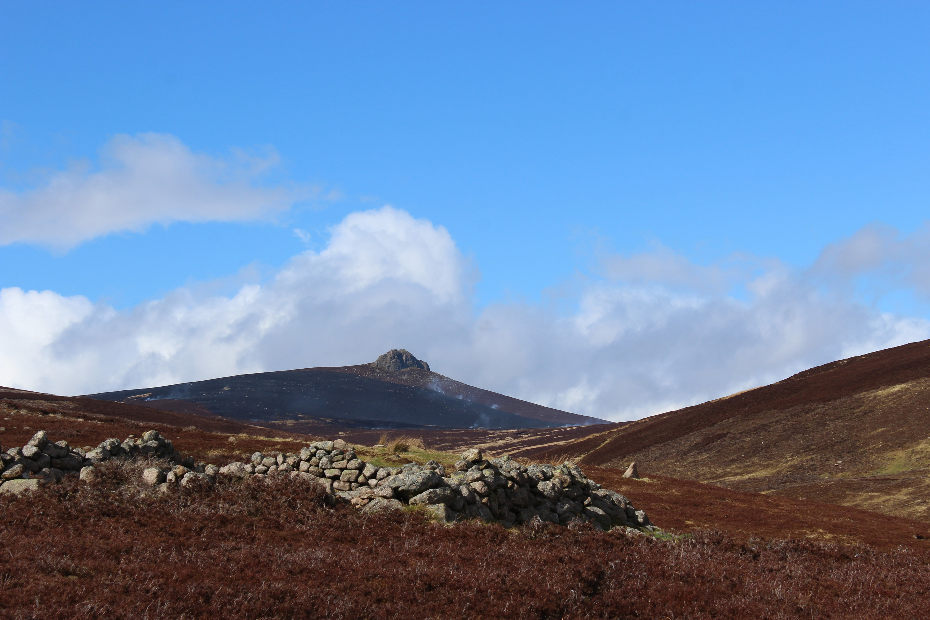
Strolling west across this broad swathe of heath and pasture grazed by sheep, little bridges conveying me over trickling streams, Clachnaben and its tor dominated the view ahead.
Approaching the base of the hill, I paused briefly at a plaque marking the work of the Clachnaben Path Trust’s volunteers in tackling the inevitable erosion caused by the thousands of pairs of boots that pass this way each year, before embarking upon my ascent.
The route rises along the southern edge of a plantation, enjoying the shelter of the trees, before striking out over open slopes of heather, the pull into the col between Clachnaben and Mount Shade more arduous.
Swinging left, the way, heads up the shoulder to the rough, misshapen chunks of granite that erupt from the summit plateau. With muirburn – the burning of heather to promote new growth – underway a little to the west, billowing clouds of smoke drifting by the mighty stone edifice created an almost mystical scene.

Where the path levels off, a ‘gateway’ in the boulders invites exploration. The scramble is straightforward – the rocks funnel into a crack and the climb through leads first to an exposed ledge with the high point up to the left.
While the granite offers good grip, great care should be taken when venturing up on to the tor for there are steep drops on all sides.
It is, however, an impressively airy perch offering panoramic views over the uplands of Angus and Aberdeenshire. On a clear day, to the north, distant Bennachie, another hill with a tor, can be seen.
A trig-point sits just back from the boulder stack and, from it, a path leads west past another rocky outcrop, dipping into a peaty pass before rising rather leisurely on to Hill of Edendocher.
Here the descent into Glen Dye begins, the track dropping over the southern flank of the hill, passing the skeletal remains of an RAF Hawker Audax bi-plane that crashed here during a training flight from Montrose in May 1939.
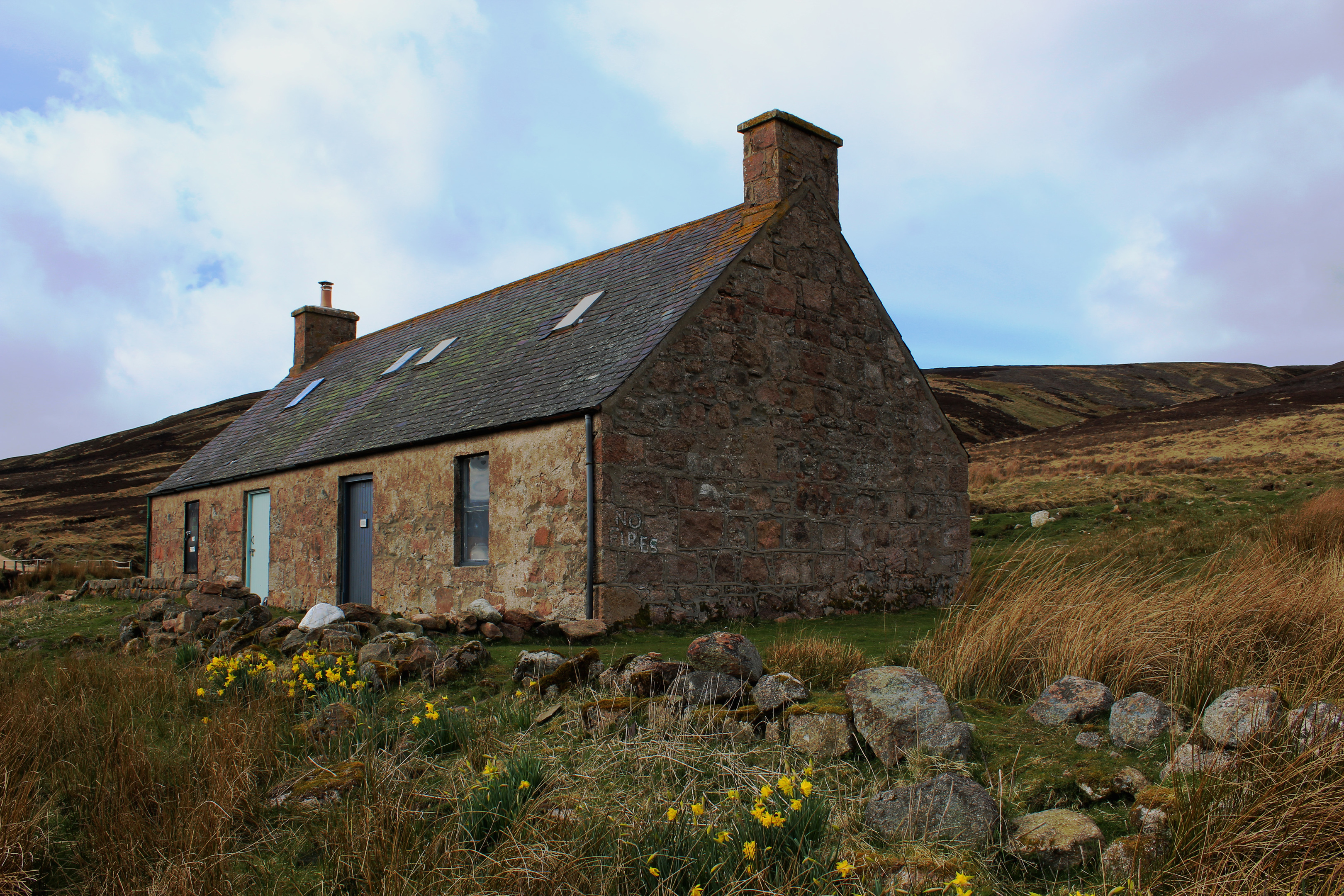
Passing over Cairn of Finglenny, I met up with the Brocky Burn for the final tumble down to Charr. Maintained by the Mountain Bothies Association as an open refuge and surrounded by the ruins of a former township, the cottage offers shelter from the elements, a welcome spot for a sit down and some refreshment ahead of the hike home.
Later, as I crossed Miller’s Bog for the second time that day, Clachnaben to my left, shoulders now blackened by the heather burning, I knew it would not be long before I returned.
ROUTE
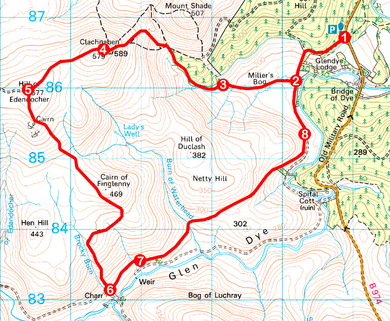
1. From information boards in car park, follow path through woodland to track junction. Bearing right, descend track by wall on left, crossing stile by gate to reach bridge over stream.
2. At junction beyond bridge, turn right, following track west over Miller’s Bog.
3. Enter woodland at ladder stile by gate and continue ahead on path, passing to left of Clachnaben Path Trust plaque. Ascend path to summit of Clachnaben.
4. From trig point, follow path west to junction on top of Hill of Edendocher.
5. Turn left and descend track to Charr bothy, in Glen Dye.
6. Turn left at track junction behind bothy, following track north-east down Glen Dye.
7. Continue straight ahead at junction above pond, following track north-east.
8. Continue ahead at junction, following track north to point 2. Retrace steps from here to car park.
INFORMATION
Distance: 14.5km/9 miles
Ascent: 620m/2040ft
Time: 4-5 hours
Grading: Moderately challenging hill walk following good tracks and paths with some strenuous ascent to an exposed summit. Explore the tor with care as there are steep drops on all sides and keep dogs on the lead at the request of the estate
Start/finish: Clachnaben Quarry car park, 750m north of Bridge of Dye on B974 (Grid ref: NO 648867)
Map: Ordnance Survey 1:50,000 Landranger sheet 45; Ordnance Survey 1:25,000 Explorer sheets 396 and OL54
Tourist Information: Stonehaven iCentre, 66 Allardice Street, Stonehaven AB39 2AA (Tel 01569 762806)
Public transport: None