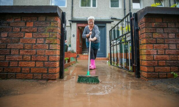
Residents hit with a deluge of flooding in Perth say they are worried they will once again be left to deal with the aftermath themselves.
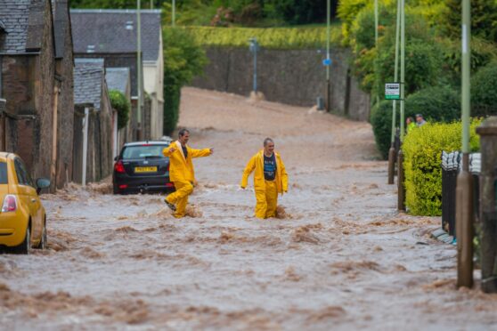
The Craigie and Cherrybank areas of the city were left submerged after heavy rains caused flooding in a number of streets on September 8.
The nearby railway station was forced to close and residents living on the affected streets warned someone “could have been killed”.
It is the second time in just over two years this area of Perth has suffered significant flooding.
Last time around, in August 2020, residents said not enough was done to support those who were forced from their homes or had precious belongings destroyed by flood water.
They now say they fear the same thing will happen again.
‘Not enough is being done’
One resident living on Queen Street said authorities did not come to her aid.
“Not enough is being done,” she said.
“You can blame it on climate change, but this happened at 9am when it was busy – someone could have been killed.
“The council puts the responsibility onto households but how can people do that if they are away at work?”
She has now written to Thomas Glen, chief executive of Perth and Kinross Council, to ask what the local authority is going to do to stop floods happening a third time.
A neighbour said no one came to help her when the street flooded in summer 2020.
She told The Courier: “When it flooded in 2020 my dogs had to go to the kennels for five months and my furniture took six months to get restored.
“I only had a folding chair to sit on and no carpets.
“I didn’t see anyone come to help us.
“It makes me so angry because this is people’s hard work and investment.”
She also urged the council to take action on the “horrendous” situation her and her neighbours are now facing.
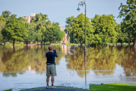
Is flooding getting worse in Perth?
Scientists declared the climate emergency is causing more extreme weather patterns such as heavy storms and rainfall across the planet.
In Perth, flooding has caused major disruption nearly every year for in the past decade.
- September 2022 – flooding hits the Cherrybank and Craigie areas, including the rail lines
- February 2021 – North Inch
- August 2020 – Cherrybank and Craigie areas
- June 2017 – North Inch and Feus Road
- July 2016 – Cromlix Road and Friarton area
- Early 2016 – Marshall Place and city centre
- September 2015 – Bridgend
- October 2013 – Friarton area
- July 2011 – Feus Road
- July 2010 – Feus Road and Fairfield area
One resident affected by the floods in Craigie last week said they are concerned new housing developments are having an impact on how much flooding there is.
The floods in September 2022 and August 2020 have been around the banks of Craigie Burn – at the top of Craigie Burn are large housing developments from Persimmon Homes and Bellway.
The Craigie resident told us there are worries about water draining from the sites.
“You can’t control it,” the resident said.
How can the council and government help?
We contacted the Scottish Government to ask them what support they are able to offer those affected by the floods in Perth.
However, we were told they could not reply to us because the government’s media team is only responding to inquiries about the death of The Queen.
Concerns have also been raised recently over how much money Perth and Kinross Council has to deal with new flood defences.
This is after the council approved £32.5 million in extra spending for the new Cross Tay Link Road, only a day before Scottish councils were told to put climate change “at the heart” of all their decision making.
This brings the total budget for the project, which the council is largely paying for, to more than £150m.
The money the council has had to borrow will take 50 years to pay back, and will restrict councillors’ flexibility in their capital spending for decades to come.
Scone Community Council also dubbed the decision “frankly unconscionable” during the climate crisis, which can cause extreme rainfall.
A spokesman for Perth and Kinross Council said: “Flooding is becoming an increasing problem across the country (and indeed across the globe), and it is not possible to prevent it entirely.
“Flooding is also becoming more frequent and severe due to the impact of climate change.
“The flooding on 8 September in Perth was due to significant rainfall – over a month’s rain fell in just over three hours – which was well beyond the capacity of the local watercourses and drainage systems.
“We understand how difficult and distressing flooding is for those who have been affected by it.
“During flood events, we work together with a number of agencies to provide assistance where possible, where resources are available and on a priority basis.
“The work continues during the recovery effort that follows.
“The council and its partnership agencies are committed to providing on-going support to those who need it the most as the recovery work continues.
“The Perth flood scheme was implemented 20 years ago and includes three flood storage ponds at Broxden.
“During flood events, these ponds hold back a good deal of water, without which the flooding downstream would have been much worse.
“The council published the Tay local flood risk management plan in 2016.
“This plan sets out the various responsibilities of public bodies, businesses and residents.
“More can be achieved in terms of reducing the risk of flooding where communities, councils and other agencies work together.
“Amongst the various actions in this plan, the council is progressing the Craigie Burn flood study and is developing a surface water management plan for Perth.
“Consulting engineers, Amey, have been engaged to carry out this work which will continue into next year.
“The council circulated questionnaires this year to allow them to input to this study work.
“Such projects take a long time to come to fruition, and any new measures to manage the risk of flooding in the future, such as new flood defences, require a long process of design, statutory approvals and procurement prior to construction.
“Funding also requires to be secured, but the ongoing study work is intended to support this process.
“In the meantime, as set out in the plan, the council continues to maintain the Perth flood scheme clear and maintain watercourses and road drainage systems, raise awareness of flooding and the actions that individuals can take, apply local and national planning policies, and provide an emergency response to flood events.
“However, individuals have responsibility to protect their own properties in the first instance.
“Therefore we continue to encourage local communities to be proactive in carrying out measures to protect their own properties and strongly advise residents in flood risk areas to maintain their own supply of sandbags, or other flood protection products, in advance of flooding.
“In recent years new development has been required to include sustainable urban drainage systems which collect and attenuate any surface water generated from impervious surfaces.
“This effectively means that new development has a neutral impact on flood risk.”