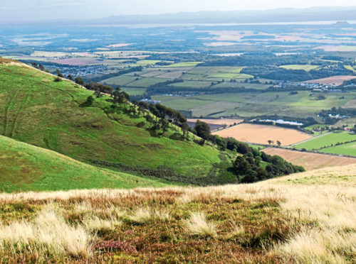
Sitting on the edge of the escarpment, overlooking the Forth valley and the Hillfoots Villages of Clackmannanshire, The Nebit is one of the most popular and prominent viewpoints in the Ochil Hills.
A relatively wee peak, the hike to the top is short but strenuous but, once there, the sweat and toil is well rewarded with panoramic vistas not only across the flat lands below but also of the surrounding hills, among them the highest in the range, Ben Cleuch.
While it attracts a steady stream of walkers, less well frequented is Craighorn, which sits to the north of The Nebit, across the valley of Glenwinnel Burn, and combines well with its lower neighbour.
The Nebit can be scaled directly from the centre of the small town of Alva but I opted to begin a little to the east, setting out from the Ochil Hills Woodland Park car park.
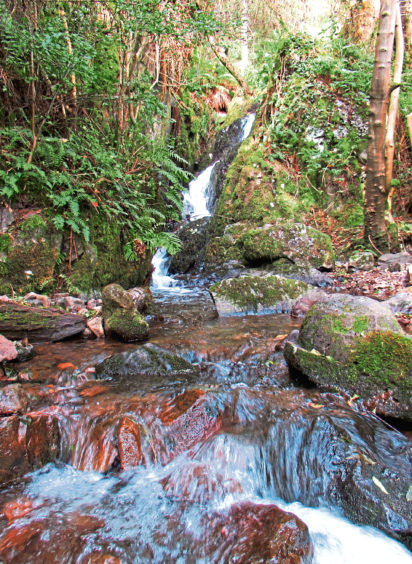
From here, a good path rises steadily through the leafy deciduous trees of the Woodland Trust’s Wood Hill Wood, crossing Silver Burn where the fenced-off entrance to an old silver mine sits just below the trail.
Silver was first discovered here in 1715 and it is said that the riches uncovered over subsequent years helped fund the Jacobite uprisings. Once the precious metal was exhausted, miners extracted cobalt, used to glaze locally produced porcelain.
Beyond the burn, the path leaves the woodland, meeting a track that loops up the hillside into the valley lying between The Nebit and Wood Hill. It is a stiff climb to the next junction where the route up The Nebit branches left.
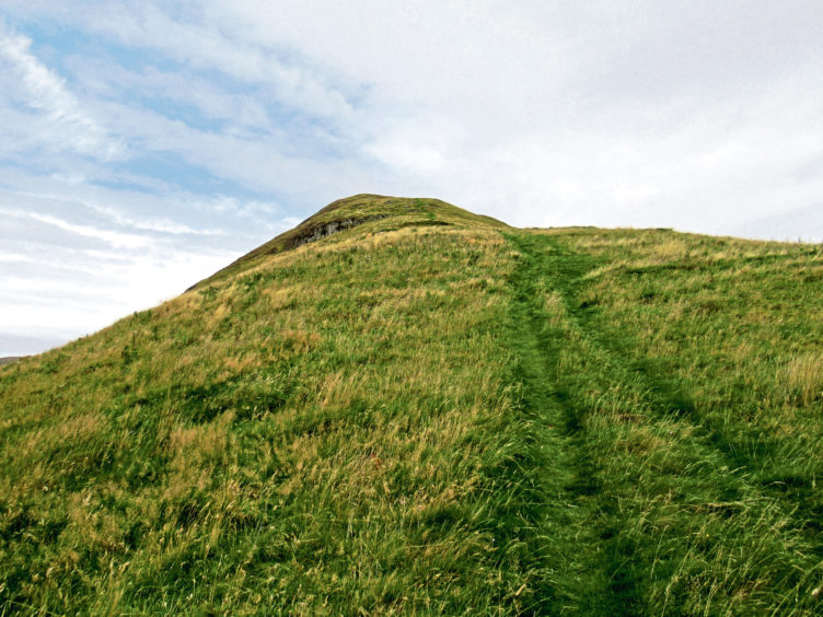
Following the track to its highest point on the shoulder – known as The Gowls – a grassy path then rises to the summit. Again, it is a strenuous unbroken ascent but, as height is gained, there are views aplenty to pause and enjoy.
The summit is marked by a small cairn from where I spied my main target of the day, Craighorn. While The Nebit is a compact dome, the top of Craighorn crowns a longer, more recumbent form.
Dipping over the northern shoulder of The Nebit to re-join the track by sheep enclosures, I tramped the gravel road, following the youthfully exuberant Glenwinnel Burn up the valley to the watershed.

Here the track curves left, fording the stream, before ending abruptly on the exposed grassy high ground. Happily, a less well defined but obvious enough grassy trail takes up the reins, leading up the northern spur of Craighorn.
The walking is easy enough, the gradient more relaxed than down in the glen and, with only a few boggy patches briefly slowing my progress, I aimed for a wooden gate in a fence that cuts across the hillside.
The summit visible ahead, the path remained faithful to my goal, rising gently through the grass and heather to a small ring of stone encircling a fence post that marks the top.
Like The Nebit, Craighorn it is an excellent viewpoint, offering a panorama over the surrounding hills, among them Ben Cleuch, to the east.
After pausing a while to soak up the scenery and savour a sandwich or two in the afternoon sunshine, I set off down the southern flank of the hill, a slender trail weaving through the grass, offering a different view of The Nebit as it descends into Alva Glen.
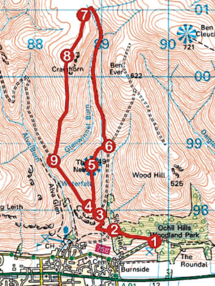
ROUTE
1. Cross car park access road and ascend woodland path (signed Upland Path Alva). Cross Silver Glen stream and exit woodland at gate beyond to meet track.
2. Turn right and ascend track, crossing stile by gate, before looping up to junction.
3. Turn left and ascend track to its highest point.
4. Branch right and ascend path to summit of The Nebit.
5. Bearing right, descend path over shoulder to corner in fence then drop east to meet valley track at gate.
6. Turn left and follow track north to its end.
7. Turning south, follow grassy path up northern shoulder of Craighorn. Where trail forks, go right to wooden gate. Cross gate and continue on slim grassy path to summit.
8. Descend path south along shoulder to meet track where it crosses Glenwinnel Burn.
INFO:
Distance: 10km/6¼ miles
Ascent: 630m/2080ft
Time: 3-4 hours
Grading: Moderately challenging upland hike with strenuous ascent, suitable for fit, experienced hillwalkers. Go equipped for all conditions and keep dogs under close control where grazing sheep are encountered
Start/finish: Ochil Hills Woodland Park car park, signed off A91 at east end of Alva (Grid ref: NS 897975)
Map: Ordnance Survey 1:50,000 Landranger sheet 58; Ordnance Survey 1:25,000 Explorer sheet 366
Tourist Information: Stirling iCentre, Old Town Jail, St John Street, Stirling FK8 1EA (Tel 01786 475019)
Public transport: Stagecoach bus service 23, linking St Andrews and Stirling, stops in Alva.