Calendar An icon of a desk calendar. Cancel An icon of a circle with a diagonal line across. Caret An icon of a block arrow pointing to the right. Email An icon of a paper envelope. Facebook An icon of the Facebook "f" mark. Google An icon of the Google "G" mark. Linked In An icon of the Linked In "in" mark. Logout An icon representing logout. Profile An icon that resembles human head and shoulders. Telephone An icon of a traditional telephone receiver. Tick An icon of a tick mark. Is Public An icon of a human eye and eyelashes. Is Not Public An icon of a human eye and eyelashes with a diagonal line through it. Pause Icon A two-lined pause icon for stopping interactions. Quote Mark A opening quote mark. Quote Mark A closing quote mark. Arrow An icon of an arrow. Folder An icon of a paper folder. Breaking An icon of an exclamation mark on a circular background. Camera An icon of a digital camera. Caret An icon of a caret arrow. Clock An icon of a clock face. Close An icon of the an X shape. Close Icon An icon used to represent where to interact to collapse or dismiss a component Comment An icon of a speech bubble. Comments An icon of a speech bubble, denoting user comments. Comments An icon of a speech bubble, denoting user comments. Ellipsis An icon of 3 horizontal dots. Envelope An icon of a paper envelope. Facebook An icon of a facebook f logo. Camera An icon of a digital camera. Home An icon of a house. Instagram An icon of the Instagram logo. LinkedIn An icon of the LinkedIn logo. Magnifying Glass An icon of a magnifying glass. Search Icon A magnifying glass icon that is used to represent the function of searching. Menu An icon of 3 horizontal lines. Hamburger Menu Icon An icon used to represent a collapsed menu. Next An icon of an arrow pointing to the right. Notice An explanation mark centred inside a circle. Previous An icon of an arrow pointing to the left. Rating An icon of a star. Tag An icon of a tag. Twitter An icon of the Twitter logo. Video Camera An icon of a video camera shape. Speech Bubble Icon A icon displaying a speech bubble WhatsApp An icon of the WhatsApp logo. Information An icon of an information logo. Plus A mathematical 'plus' symbol. Duration An icon indicating Time. Success Tick An icon of a green tick. Success Tick Timeout An icon of a greyed out success tick. Loading Spinner An icon of a loading spinner. Facebook Messenger An icon of the facebook messenger app logo. Facebook An icon of a facebook f logo. Facebook Messenger An icon of the Twitter app logo. LinkedIn An icon of the LinkedIn logo. WhatsApp Messenger An icon of the Whatsapp messenger app logo. Email An icon of an mail envelope. Copy link A decentered black square over a white square.

Residents in Angus warned flooding disruption is not over despite alerts being lifted

Flooding has caused problems on many roads in Angus.

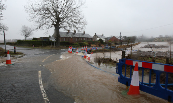
It will be some time before Angus returns to normal after a week of ceaseless bad weather, residents have been warned.

More than 3,800 sandbags were distributed following Storm Frank and a prolonged period of rainfall, which appeared to abate.

But rain was expected to give way to ice and snow at greater heights, with the Met Office issuing a yellow weather warning for the county until 10am.

Rail and bus services disrupted by flooded tracks and roads resumed, but seven schools remained closed while standing water kept some roads shut.

The affected schools were Airlie, Eassie, Inverarity, Isla, Lethnot, Stracathro and Tarfside. Tannadice primary was only open to pupils who did not require school transport.

Flood warnings for a variety of areas in Angus were lifted after being in place for more than a week.

Warnings for Logie Mill and Craigo, Kinnaird/Bridge of Dun, Inchbare, Finavon and Tannadice and Brechin were removed by the Scottish Environmental Agency.

However a flood warning is still in place for Arbroath, after water levels around the town caused massive disruption to train services between Dundee and Aberdeen on Thursday night, with all services cancelled at around 4.15pm.

Flood warnings for Stonehaven and Marykirk were also lifted.

Stonehaven residents watched the Carron Water with concern on Thursday night but wardens were stood down on Friday morning as levels appeared to diminish.

As flood-affected communities await the full extent of the devastation to be revealed, Angus councillor David May has praised the emergency services and local authority response to Storm Frank and the subsequent flooding events.

“I have spoken to some of the residents in areas such as Craigo and Logie about the flooding and how it has affected them, their neighbours and their business,” he said.

“The residents told me they have the highest possible regard for the emergency services and the council and all the help they have been given.

“The residents have clearly also been doing everything possible themselves and thanks are also due to local farmers who have also been first class in their efforts to lessen the impact of the flooding.”

It is expected that the B956 Horniecross to Tannadice will remain closed at the C32 junction, along with the B9113 at Rescobie and the Craig O’ loch Road at Forfar.

An Angus Council spokesman said: “In the coming days and weeks our staff will be identifying and assessing damage and the repair work required to our roads, drainage and infrastructure.

“There will be a great deal of work to be done and this will be prioritised. Please bear with us.”