The small wooded Moncrieffe Hill to the south of Perth is perfect for a half-day excursion for all ages, with its network of nature trails and a fascinating glimpse into the distant past.
The summit known as Moredun Top is crowned by a 2,000-year-old Iron Age fort, the largest of the many scattered throughout the Tay Estuary, and it’s believed it covered an area equivalent to two football pitches. Another smaller fort can be found to the south-west.
Parts of the ramparts which encircled the fortifications are still visible. Within these walls there would have been several family houses and, in times of conflict, those living on the lower slopes of the hill could seek safety for themselves and their livestock.
Moncrieffe Hill was also the site of a battle in 782 between Pictish warlords Angus and Alpin. Excavations have revealed the hill had special significance as a royal centre. During the 18th and 19th Centuries, it was extensively planted and there are still a few survivors of this old woodland.
There are two main starting points, both with information boards, and five waymarked trails. The northern Tay car park off the Rhynd road has more spaces, and is generally busier being a shorter route. It is also handier for those wishing to follow the sculpture trail (green markers).
The quieter southern approach, along a series of minor roads east of Bridge of Earn, offers a longer and more satisfying walk (red route). Whichever one you choose, however, involves a fairly steep climb at some point. There’s plenty of scope for combining trails and making your own adventure.
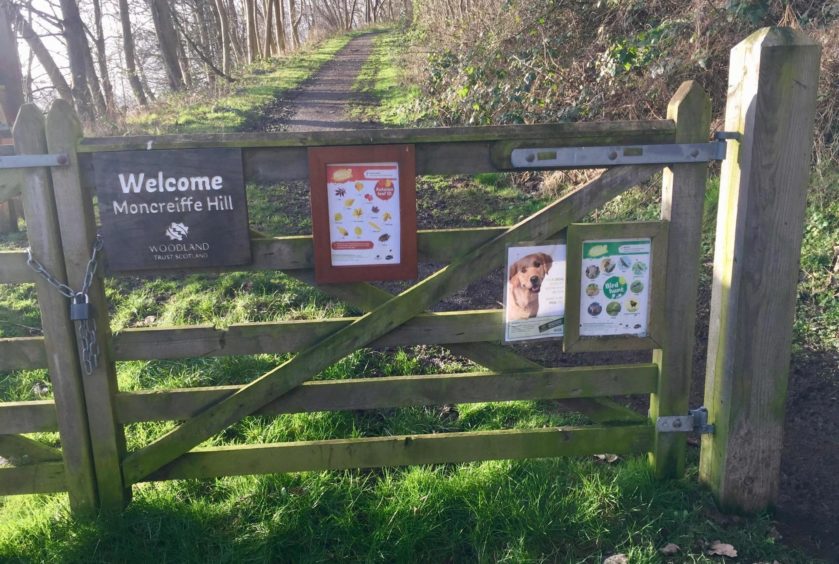
I arrived late afternoon in conditions that felt more like spring than winter. There was just one other vehicle and I parked carefully just below the wooden gate across the track. As well as the welcome sign on the gate, there were handy identification guides to flora and fauna.
Amongst the birdsong which occasionally echoed through the trees, I could hear the distant drumming of a woodpecker, but had no luck in catching a glimpse of this arboreal percussionist. It seemed the red squirrels and roe deer were keeping their distance as well.
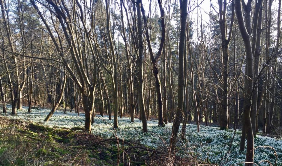
A little further in and what I thought at first to be a large patch of snow turned out to be snowdrops, a bold swathe of unblemished white further illuminated by rays that had managed to penetrate the stripped tree cover.
After so much tranquillity, there was a bit of a rude awakening as the track took a dip and ran alongside the busy A90 but the intrusion was short-lived as a waymarked path led me uphill to the right and left the traffic noise behind.
A clear section among the trees gave grand views to Perth before the path looped right again, past a small pond to arrive at a junction and notice board below the smaller fort. A short diversion along a grassy path took me to a trig pillar and open views south towards the Lomonds.
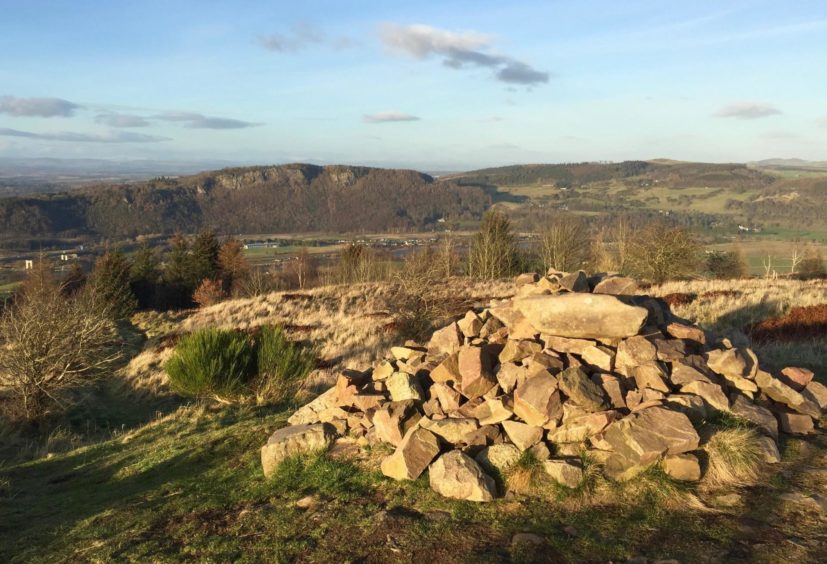
A bit more twisting and turning led round the foot of the grassy ramparts of Moredun, easing the way upwards to the summit cairn. The views were extensive: the Tay a crooked sliver of blue sliding through the landscape in the evening light, the sprawl of Perth to its left, Kinnoull Hill and its tower to the right.
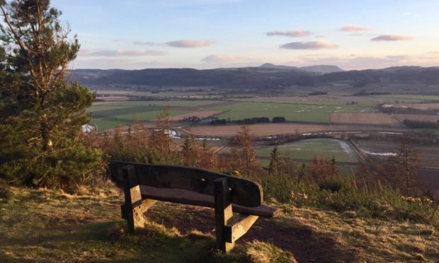
I retraced my steps to the main notice board at the final junction and then turned sharp left. This branch of the path stayed high, running above an escarpment and providing grand deep views south over Fife at regular intervals over the tops of the trees. A wooden bench at one particular spot is a fine place for a time-out with an impressive clear line of sight.
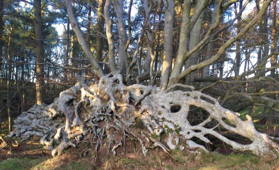
Tree lovers will enjoy the sight of some of the older trees along this path. They are reminiscent of sculptures themselves, massive exposed roots, bleached and twisted over the years, thrusting out to form alien shapes.
The end comes quite abruptly, the path zig-zagging downhill to emerge on the inward track, less than a kilometre from the start. The silence was still in place, though.
Route
1. Go through wooden gate with information notices and head west along track (red trail) through mixed woodland for just over 2km ignoring any right turns.
2. When track starts to dip closer to M90, take waymarked path on right and head uphill.
3. After reaching break in trees, follow the path loop right to reach small pond then path junction just beyond. On the right is an information board and remains of the lower fort which is topped by a trig pillar.
4. Return to path and continue uphill through trees again looping to right to another information board. It then contours round initial steep grassy rampart to emerge on Moredun Top (cairn).
5. Retrace steps back to info board and turn left, staying high on path heading east, at one point passing along top of escarpment, before it winds down through wood to join inward track.
6. Turn left at junction for short walk back to start.
Lowdown:
Distance: 8km/5 miles
Ascent: 250m/820ft
Time: 2-3 hours
Grading: Woodland tracks and paths, steep but steady ascent, suitable for all ages. Can be muddy, good footwear recommended.
Start/finish: Moncrieffe Hill woods parking area (Grid ref: NO 153192) near Easter Moncrieffe.
Map: Ordnance Survey 1:50,000 Landranger Map 58 (Perth & Alloa); Ordnance Survey 1:25,000 Explorer sheet 369.
Tourist Information: VisitScotland, Perth iCentre, 45 High Street, Perth, PH1 5TJ (Tel 01738 450600).
Public transport: Buses and trains to Perth, but no public transport to start of walk.
- You can follow Alan’s regular mountain adventures at munromoonwalker.com or on Facebook (Munro Moonwalker) and Twitter (@munromoonwalker)
- Please observe government coronavirus safety guidelines in all outdoor activities.


