Pressendye is the high point in a long, rolling ridge which forms the watershed between the Dee and the Don and as such the routes to its summit are many and varied.
The circuit from the tidy village of Tarland to the south gives a satisfying day out that has a little bit of everything and is neither too long or too strenuous.
The approach starts off on minor roads before heading up through trees to reach open hillside, and then meandering along the wide ridge to the huge summit cairn, before descending via a series of twisting forest tracks and paths.
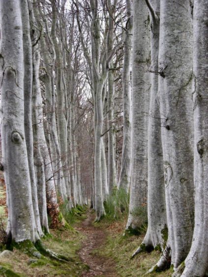
There’s also a lovely sting in the tail which will delight adults and children in equal measure as the path squeezes down through a fairytale alley of tall beech trees.
There’s ample parking in the centre of the village, and I had the feeling when I left the car that the place hadn’t quite wakened up yet. The quiet feel continued on the traffic-free way out as I picked up the minor road heading north-west past the entrances to numerous farms.
Off to the west, the bulky presence of Morven was a constant companion, rising above the surrounding countryside with the last streaks of the season’s snow striping its bold, dark slopes.
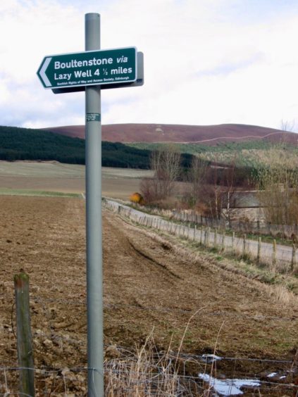
The lengthy ridge which includes Pressendye seemed to be getting further away with every step forward, but that all changed when I reached the end of the road at a sign for Boultenstone. Here the track led up to the edge of a fir plantation and then through a gate into the trees to eventually emerge on the open hillside of Broom Hill.
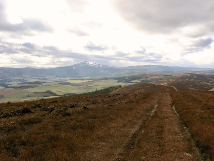
The walking so far had been easy, the angles gentle, and it continued in this vein as I followed the track east through the heather along the ridge. It is worth noting that this ridge is exposed for a long section and the walk could prove to be a different beast in wild conditions.
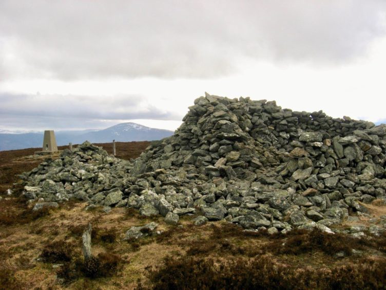
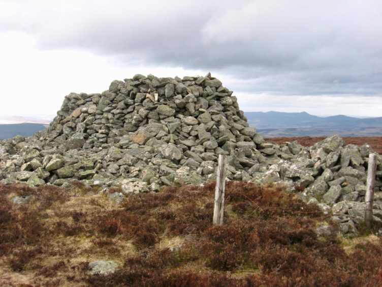
There is a trig point at the summit along with a huge shelter cairn, handy for offering some protection from the elements should that be necessary. The hill is popular with cyclists and runners, and the cairn sometimes contains a small refreshments cache.
The most challenging part of any circuit is likely to be the bewildering array of tracks and paths strewn across the slopes, an ever-changing network with many not marked on older maps. The return route in particular will keep you on your toes, but there is always another option to find your way back.
I caught the first main track switch as it swung round the wooded hill of Pittenderich, a sharp right bending down and out of the trees, but nearly missed the turn on to a fainter path along a pylon line.
The final stretch to reach the road leading back towards Tarland includes the aforementioned path through the line of birch trees: depending on the weather, the atmosphere can feel a little eerie, more towards the Grimm end of the fairytale spectrum but it is still the highlight of the walk.
Once down to the minor road, your homing instinct should kick in and it’s an easy stroll back to the centre of the village.
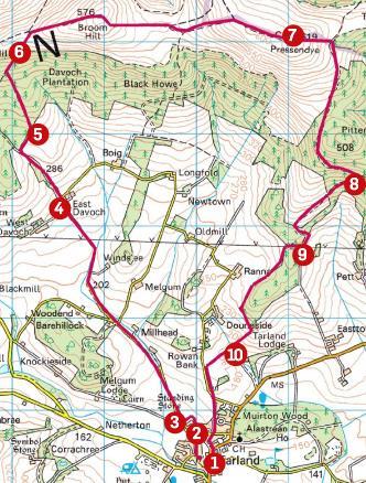
Route
1. Head west passing right of war memorial and follow road curving right then straight ahead to go across grass and reach track.
2. Keep left at fork, right through gate and left on path until minor road and turn right.
3. Follow road NW and keep straight ahead (signed West Davoch), pass entrances for Winds’ee on right then West Davoch on left to reach East Davoch and take track signed for Boultenstone via Lazy Well.
4. Follow track uphill through gate and alongside trees and turn right by fence heading towards Davoch Plantation.
5. Go left through gate to follow path through trees turning right at marker post to gate in deer fence.
6. Follow faint track along ridge to fence and turn right on track following fence line. After passing small lochan, path veers to meet another track. Head left back to fence, pass through gate and follow old fence to summit.
7. To descend, take marked track east, go right at junction and follow it through trees then turn sharp right on to smaller track heading downhill.
8. Follow blue and red markers (ignore waymarked path to right), turn right on another track going left downhill and at bend watch for right turn on to fainter track to small rise beside pylons.
9. With forestry on left, keep straight ahead on marked path before taking narrow path heading down through trees. Go right over stile beside metal gate to follow path lined by beech trees and cross bridge over burn.
10. Continue straight ahead, ignoring red route going left, to reach minor road. Turn left, and when road bends left go straight ahead on grassy track to another road and turn right then left to parking.
Information
Distance: 14.5km/9 miles
Ascent: 560m/1,830ft
Time: 3-4 hours
Grading: Minor roads, farm and woodland tracks, hill paths. Gentle ascent to exposed ridge, suitable for relatively fit walkers, pleasant walking for families. Can be wet underfoot, sturdy footwear advised. Dogs under close control due to farm livestock.
Start/finish: Parking in The Square, Tarland (Grid ref: NJ 480043).
Map: Ordnance Survey 1:50,000 Landranger Map 37 (Strathdon & Alford); 1:25,000 Explorer sheet OL59 (Aboyne).
Tourist Information: VisitScotland, Ballater iCentre, Station Square, Ballater, AB35 5QB (Tel 01339 755306).
Public transport: None to start. Nearest bus stop at Aboyne on Aberdeen to Ballater (No 201) route.


