The Caledonian Canal is one of the great waterways of Europe, built by Thomas Telford, one of Scotland’s greatest engineers. Running north-east to south-west, it connects the east coast at Inverness with the west coast at Corpach, near Fort William, at the head of Loch Linnhe.
Only one third of its 60-mile length is man-made, as Telford used the waters of Loch Dochfour (below Inverness), Loch Ness, Loch Oich and Loch Lochy – which are conveniently linked along the geological fault that is the Great Glen, at a huge saving in cost – to create the canal.
A principal reason for its construction was to provide employment and stem the flow of manpower from the Highlands following the Clearances. Today’s questionable political optimism about the cost and completion time of major civil engineering undertakings is nothing new. By the time the canal opened in 1822, it was nearly three times over budget and had taken twice as long to complete as originally planned.
The canal cut out the sometimes hazardous east/west voyage for ships, which hitherto had to sail round Scotland’s north coast through the wild waters of the Pentland Firth, which separates the mainland from the Orkney Islands, and round Cape Wrath, the most north-westerly point of mainland Scotland.
As an etymological aside, the cape’s name has nothing to do with the angry waters of the Pentland Firth – which they most certainly can be – but is derived from the old Norse word for turning point. The headland is on what had been a busy Viking sea route and was a navigation point where, after their raiding excursions, the Norsemen turned their longships, laden with booty, to head for home.
The last time I drove the length of the canal was 40 years ago, after a family camping holiday on Benbecula and Skye. As a fun day out on our holiday in the Black Isle, I suggested to the Doyenne that we should drive down the west side of Loch Ness (A82) to Fort Augustus, at the foot of the loch, for lunch.
Forty years is a long time and much has changed. Almost all views of the loch, along its whole 22 miles, are obscured by trees which have grown up and tall bracken. Romantic tourists’ hopes of catching a glimpse of Nessie must be, sadly, thwarted. If I was to make the trip again I would hope to do it on a sunny winter’s day when the leaves are off the trees and you can appreciate the grandeur of the surroundings.
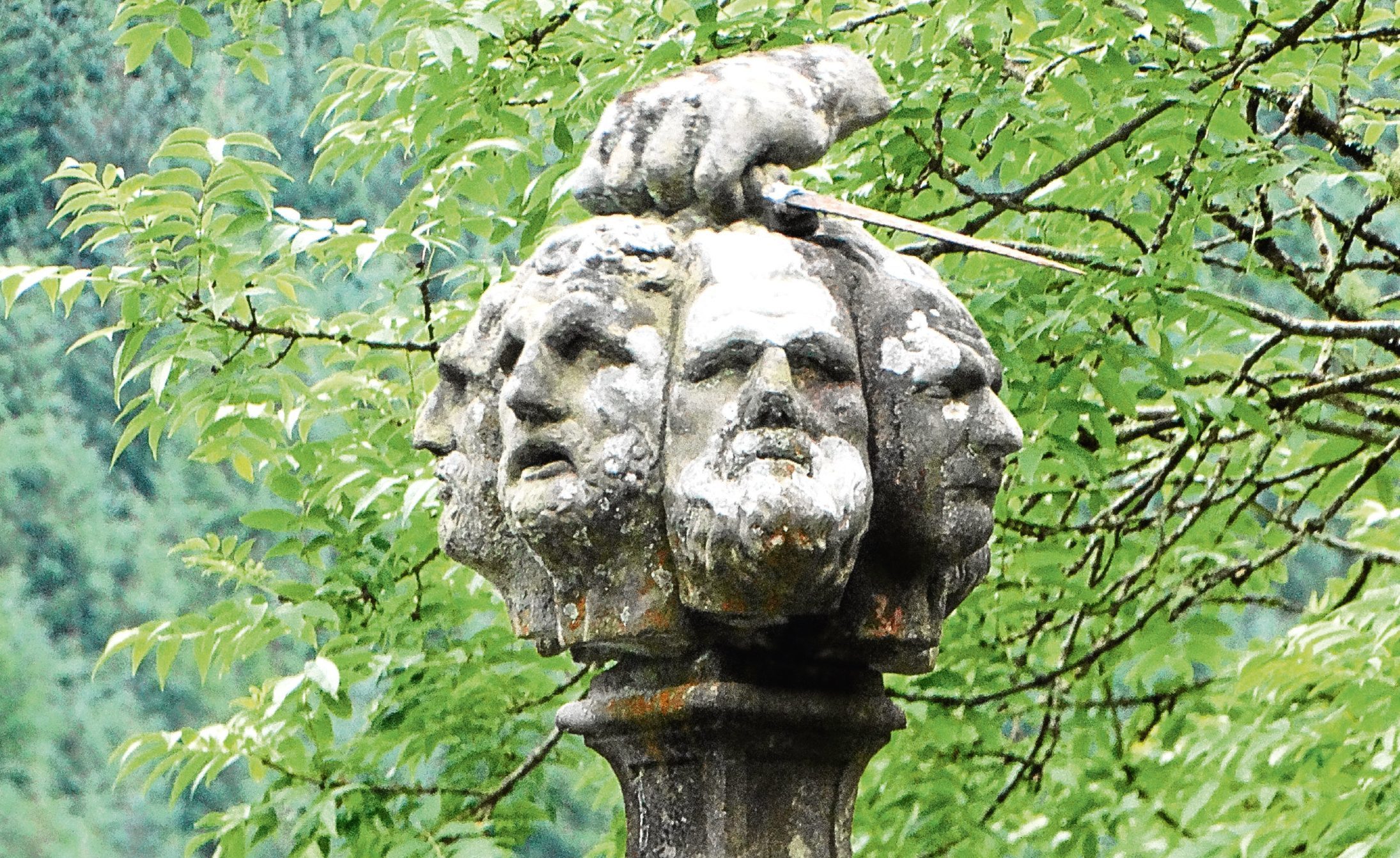
Rough justice
Ten miles below Fort Augustus, by the side of Loch Oich, is a grim monument to summary Highland justice. Inter-clan warfare was commonplace but this was a case of revenge killing within the MacDonald clan which occurred in 1663.
As ever, accounts of such events are varied and often conflicting, but there is no doubt that Alasdair and Ranald MacDonald of Keppoch were murdered by their uncle Alasdair Buidhe of Inverlair, and his sons, in a brawl that got badly out of hand.
Ian Lom, the Keppoch Bard, a kinsman of the victims, swore vengeance and vowed to bring the perpetrators to justice.
Under “letters of fire and sword” and leading a force of 50 clansmen provided by MacDonald of Sleat, he marched on the house at Inverlair, which he found barricaded. The house was set afire, forcing out the seven men inside, who were promptly put to the sword and their heads severed from their bodies.
On his way to Invergarry Castle to show the mutilated heads to MacDonnell of Glengarry, High Chief of the Clan Donald, as proof that suitable retribution had been exacted, Ian Lom stopped to clean them in the waters of the roadside spring which has since been known as Tobar-nan-ceann – Well of the Heads. The well is at the head of a cave beneath the monument and extending below the main road. If you should visit it, take a torch as it is quite dark.
Lighter moments
Back at Fort Augustus, we took the south road (B862) to Inverness, which I had never driven. As on the north side, trees and undergrowth obscure views of the loch. The road turns away from the lochside and climbs until you are looking over the broad panorama of Strath Nairn.
We are always aware, on our trips north, of the sense of heightened light. The fingers of the Moray Firth and Beauly Firth, the Cromarty Firth and the Dornoch Firth extend deep into the Easter Ross coastline, folding back the hills and creating boundless views of far peaks – very different from the much more compact Angus glens but summing up the infinite variety of Scotland’s landscape.
I took Inka out for his last walk up the usual track and was greeted with the familiar spicy smell – the most romantic scent I know – of hedgerow honeysuckle hanging on the damp evening air. We were home.