Norman’s Law is a well-trodden hill and a perfect fit for shorter days or those brief interludes of calm between seasonal blasts of rain and wind.
It’s the highest point in north Fife and its popularity is enhanced by the relative ease of ascent compared to the rich reward of the view over the Tay estuary to Dundee that awaits those who reach the summit.
The trade route is from the village of Luthrie to the east, but the passage of so many feet can make this a bit of a mudbath at times. I opted for a quieter approach from the south.
There’s room for a few cars to squeeze in beside a fence at a wide area near Ayton Smiddy but any worries I had about overcrowding were soon dispelled. I was the only one there, and that was to remain the state of play for the duration of the walk.
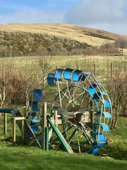
Care is needed crossing the main road to reach the farm track opposite which leads past Ayton House and then to a signed split in the track. A right turn passes another cottage with a colourful, working water wheel in the garden. This is the work of metal-worker Mike Robertson, who also made the direction indicator on top of the hill.
Straight on is Denmuir, a derivation of Dun Mor (big fort), the ancient Gaelic name for Norman’s Law which referred to the Iron Age fort on the summit. It was only in the early 17th Century that the current name came into common use, most likely from the belief that raiding Norsemen had camped there.
Beyond Denmuir, the route passes a small pond and continues to a gate marked with an arrow to prevent the walker straying into the grounds of the houses on either side. Then the uphill work starts.
The path is sometimes reluctant to show itself but the grassy ascent is simple, one small detour, which involves contouring round to the right of a small top before regaining the line by a fence along the side of a wood.
The thick wall of gorse bushes on the right should be enough to deter anyone from looking for a quicker way to the summit. Instead, stick to the fence until it takes a sharp left, continue straight on where there you will find a choice of the paths to the summit – any one will do.
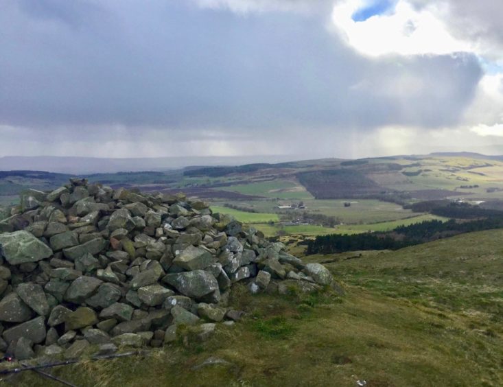
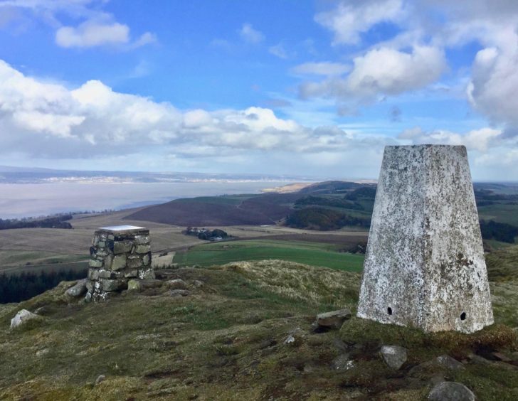
There is a trig point, the afore-mentioned direction indicator and a cairn, and around the summit area are the remains of the fort. The expansive views of the surrounding countryside confirm its strategic defensive qualities.
The views north and east were hazy, but to the south the Lomonds were being swallowed in a fast-moving grey squall. Strange how watching rain from a distance is almost hypnotic.
With a chill wind whipping round, it was time to head back down by the fence line. A massive fallen tree lying across the path was evidence of the power of recent storms, but it was easy enough to work round.
A log gate on the right led into the woods, a muddy path through ranks of leaf-stripped trees to emerge at a more substantial track. This is part of the Fife Coastal Path, an inland extension created to bypass private land.
The track swung gently to the right, then back to the left, passing the entrance to a house, developing as it emerged from the tree cover into a more substantial lane flanked by green fields and drystone dykes.
Norman’s Law dominated the view in the rear mirror for the last mile or so, the summit prominent above pale slopes adorned with dark garlands of gorse. The track eventually meets the junction with the incoming route above Ayton House and from there it’s less than ten minutes to the finish.
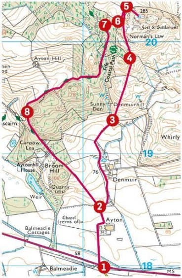
Route
1. Cross A913 with care and head N up track opposite, passing Ayton House on right.
2. Go right at fork just beyond at signpost and pass another cottage on right.
3. Head straight on at Denmuir, passing a pond to reach a gate (marked with arrow) that goes between entrances to two houses.
4. Follow sometimes vague path up grassy slope, turning a small top on the right, and ascend fence line by a wood.
5. Once you are below a crag on the right, take one of the grass path options leading to summit.
6. To descend, return to the fence and follow it down until you come to a wooden gate.
7. Go through the gate and turn left on to track, part of the Fife Coastal Trail.
8. Keep following main track (ignore first branch on left) as it curves to the right and then left to reach a long straight which leads back to Ayton House.
The Lowdown
Distance: 5km/3 miles
Ascent: 230m/760ft
Time: 2-3 hours
Grading: Country lanes, tracks, and grass paths. Easy ascent for all abilities, some muddy patches, substantial boots recommended. Farmers request dogs kept on leads. Care needed crossing main road.
Start/finish: Park carefully beside fence off minor road near Ayton Smiddy (Grid ref: NO 303180) off A913 Newburgh to Cupar road.
Map: Ordnance Survey 1:50,000 Landranger Map 59 (St Andrews); Ordnance Survey 1:25,000 Explorer sheet 371.
Tourist Information: VisitScotland, St Andrews iCentre, 70 Market Street, St Andrews, KY16 9NU (Tel 01334 472021).
Public transport: Very limited public bus service to start point.
- You can follow Alan’s regular mountain adventures at munromoonwalker.com or on Facebook (Munro Moonwalker) and Twitter (@munromoonwalker)