Auchtavan and Glen Feardar, Deeside
I SHOULD have been in Torridon tip-toeing along the spiny crest of Liathach. Instead, I found myself gazing down the long sweep of an empty glen in the Cairngorms.
Two completely contrasting landscapes, each with its own brand of beauty.
The sudden change in weather forecast had thrown a spanner in the works: staying east meant a clear guarantee.
It seemed the ideal moment to visit the old settlement at Auchtavan.
Lying at 450 metres above sea level, this is a rare example of a traditional Highland clachan or fermtoun.
Before the Industrial Revolution
The farming families who lived here in the days before the Industrial Revolution had no gas or electricity, no running water.
They would walk miles to school, to church and to the nearest stores in Braemar.
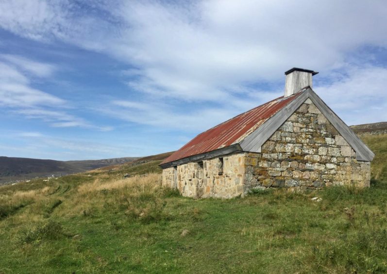
Most of these settlements have long disappeared but careful and constant restoration work has ensured that three buildings still stand at Auchtavan – the hingin’ lum cottage and the horsemill, and a 20th Century house, once the Queen Mother’s picnic cottage.
Auchtavan is Gaelic for the field of the two kids (a traditional rental paid for the land to the laird of Invercauld was two young goats).
The horsemill is always open and there are information panels inside, but please remember to close the door securely when you leave.
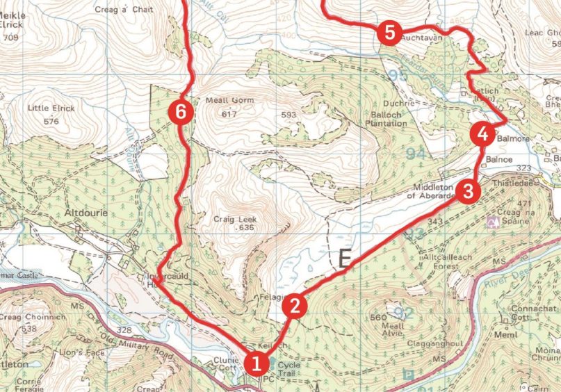
The conventional start to the walk is from a layby on the A93 near Inver. I decided on a longer but more aesthetically pleasing route from Keiloch which would allow me to return via Glen Feardar.
Turning right immediately after leaving the car park on the track heading through the trees, I passed the white cottage of Felagie, then continued to a high metal gate.
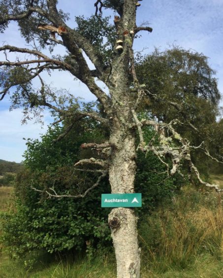
Just beyond, I branched left to join the track which goes past Balnoe then through the farm of Balmore to reach a wooden bridge, framed by rowan trees, which crosses the Feardar Burn.
Caught between seasons
The day seemed to be caught between seasons: the stifling heat and blue skies were definitely of summer, the golden fleeces glistening in the trees a sign that autumn was already making inroads.
The fungi was brilliantly coloured, butterflies, dragonflies and beetles were in abundance and there was even a slow worm stretched out sunning itself, but the heather had started the fade from its bright purple and pink to more sombre hues.
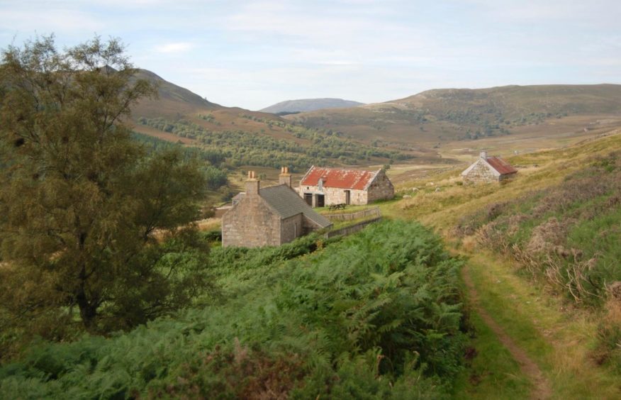
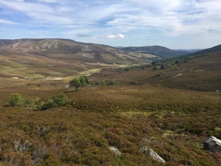
The track went left, rising gently all the time, taking a right swing then a left before the first signs of the settlement came into view, field walls and shielings, foundations overrun by bracken.
Then as I crested the next rise, the red roofs came into view.
A prime location
Forget the hardships for a minute: as prime locations go this is hard to beat.
The view down the glen was achingly beautiful, and the huge presence of Lochnagar and its satellites filling the skyline to the south in a shimmering blue haze simply sensational.
I sat for a while, watching the swallows darting here and there while two buzzards appeared from opposing sides to perform an aerial ballet high overhead with full sound effects.
Deeper into Glen Feardar
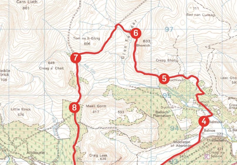
I said goodbye to Auchtavan and continued on the track as it ran west across the lower reaches of the hillside before taking a turn north, heading deeper into Glen Feardar.
The hill grabbing the attention dead ahead was Culardoch, one of two Corbetts in this glen, but in this heat they would have to wait for another day.
Instead, I turned left at the next junction and again at the next to pick up a track running south.
When it split just below a felled area, I took the left branch to a high metal gate.
The way beyond was a pleasant descent through mixed woodland which eventually brought me out on the tarmac estate road and the short haul back to the start.
ROUTE
1. Leave parking area and take track on right (signed Inver via Felagie) passing between estate buildings to continue through trees.
2. After passing white cottage (Felagie) keep following track along edge of trees, ignoring path going left, until reaching high metal gate.
3. Go through gate and immediately branch left off main track, going through field by wooden gate to connect with track running north past Balnoe to farm at Balmore.
4. Follow track through farm, ignoring left turn, to cross wooden bridge over Feardar Burn, then go left (signed Auchtavan). After another metal gate, main track bends right, then left before turning west to Auchtavan.
5. Continue west to pedestrian gate in fence, then follow track as it rises across hillside and swings north up Glen Feardar. The hill directly in front is Culardoch.
6. When path reaches stream crossing, go left to reach another path junction then left again until linking with track running south.
7. When track splits about 2km further on, take left branch beside cleared area to high metal gate giving entrance to forest.
8. Follow as path weaves downward through trees to reach estate road, turn left to return to car park.
INFORMATION
Distance: 18.5km/11.5miles
Ascent: 470m/1540ft
Time: 4.5-6 hours
Grading: Estate, farm and woodland tracks and paths, rough and stony in places, suitable for walkers with decent level of fitness. Sturdy footwear recommended. Section over open moorland needs respect in poor weather. Dogs under close control due to farm livestock and ground nesting birds.
Start/finish: Parking area at Keiloch (Grid ref: NO 188912) off A93 east of Braemar (£3 per vehicle).
Map: Ordnance Survey 1:50,000 Landranger Maps 36 (Grantown & Aviemore) and 43 (Braemar & Blair Atholl); Ordnance Survey 1:25,000 Explorer sheet OL58.
Tourist Information: VisitScotland, Ballater iCentre, Station Square, Ballater, AB35 5QB (Tel 01339 755306).
Public transport: No public transport to Braemar from south, bus service from Aberdeen (201) but no stop at Keiloch which is three miles west of Braemar.


