I suppose it’s no surprise that Duchray Hill, also known as Mealna Letter, has a bit of a split personality sitting as it does on the boundary between Angus and Perthshire, writes Alan Rowan.
In all the years I have been tramping the hills, I have heard it referred to as Duchray Hill, which is likely derived from dubh coire, therefore hill of the dark corrie.
But driving west along the B951 on a below-zero morning, Mealna Letter – from meall na leitir, hill of the broad slope – certainly appeared to be the more appropriate name as its wide frontage was lit by bright sunshine while its neighbour on the other side of the road, Meall Blair, remained in the icy shadows.
The route I was about to do also seemed fitting in the current climate: starting in Angus with a walk up the hill, then dropping over the border to Loch Beanie and returning by the Cateran Trail alongside the Water of Shee.
I parked in the same place I did last time out, squeezed off the road at the edge of a small plantation just before the Welcome to Perth and Kinross sign. But things had changed since I was last here.
The route that has been touted for so many years – following the edge of the tree line north until you reach more open ground – cannot now be recommended. The entry gate is padlocked and new, high fencing forces you to the right away from the original line of the faint path.
I decided to persevere to satisfy my curiosity. The initial trek was always a bog trot, but it was nothing compared to this. After battling my way through awkward vegetation interspersed with water-filled traps, I found relief on higher ground and spotted what looked like a gate in the fence higher up. It turned out to be solid panel fencing barring onward progress, climbable for some but uncomfortable and certainly not for dogs.
After surmounting these hazards, I arrived at the summit to find a friend coming up from my left. He had taken what I would recommend as the sensible approach, using a forest track off the minor road to Dalnaglar Castle less than a kilometre from my starting point.
This track does not appear on some maps, but it is clear and obvious, and so long as you stick to the main drag and ignore any left branches it brings you out above the treeline. From there it’s a short haul over to the drystone wall which leads directly to the top.
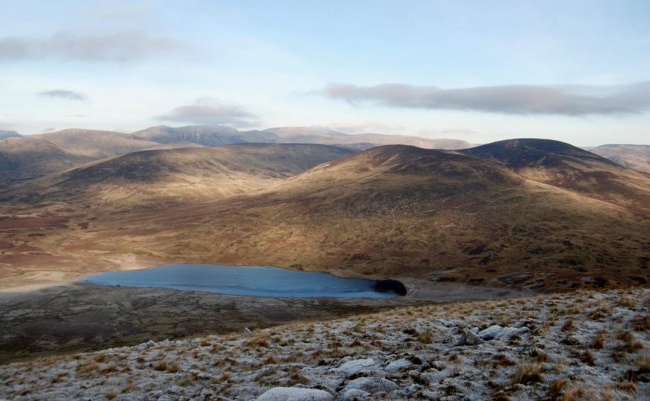
The summit is at the junction where the wall turns east towards Glen Isla, but a big cairn a little to the west gives the best viewpoint, all the way up Glenshee which today was doing its best impersonation of the Lake District.
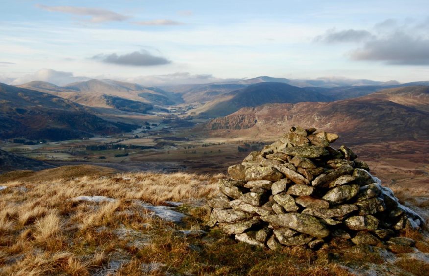
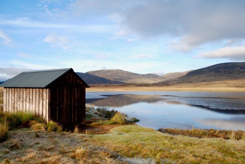
Loch Beanie was a blue oasis below and the drop to its shoreline, although pathless most of the way, was speedy. A substantial memorial cairn would provide a handy marker in thick weather, and there are signs of a faint path in the latter stages.
The water was like glass, reeds standing as though frozen in place, with Craigenloch Hill on the far shore perfectly reflected. There seemed to be as much water on the path west from the boat shed and it needed occasional diversions to avoid the worst of the swamp. Once across the wooden bridge over the Allt Mor, the underfoot conditions improved, but not by much.
The path disappeared in places but it always re-emerged. At a deer fence, I went through the wooden gate then further on, over a couple of stiles to emerge on the track skirting the farm buildings at Invereddrie. A short distance down the track I reached a stile by one of the Cateran markers pointing the route south.
This was a delightful stroll – just one diversion to take you around the policies of another farm – along the edges of fields of sheep, across little bridges, and over a series of stiles and gates. It eventually reached the grounds of Dalnaglar Castle, where a track took me round to emerge a few hundred metres from the parking spot.
There was just the small matter of the walk back to the county boundary. It’s not one I will need to do again.
Route:
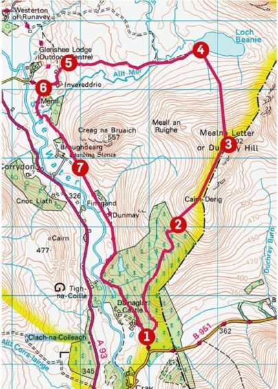
1. Start from parking area and take track (not marked on 1:50,000 maps) which weaves its way north through trees, ignoring all left branches, to emerge above treeline.
2. Head NE to drystone wall at Cairn Derig and follow to summit of Duchray Hill.
3. Drop N on rough ground, picking up faint path further down and passing memorial cairn, to reach boat shed on shores of Loch Beanie.
4. Take wet path west to bridge over Allt Mor, cross then follow to deer fence. Go through wooden gate, head slightly uphill on sometimes faint path to reach wall with stile.
5. Cross into field, exit by another stile, and take track past farm buildings at Invereddrie. Short distance after track swings west, watch for stile on left (marked Cateran Trail) and cross on to farm track.
6. Follow the trail markers south along the edges of fields. There is one sharp turn to skirt the farm of Broughdearg, before you regain the trail via a high stile.
7. Keep following the signs to reach a rough track which goes round the wall of Dalnaglar Castle grounds to reach the road near the parking place.
Information:
Distance: 12km/7.5 miles
Ascent: 440m/1,450ft
Time: 4-5 hours
Grading: Forest, farm and ATV tracks, some rough pathless sections, can be wet and muddy. One steady climb to Duchray Hill, reasonable level of hill fitness needed. Dogs under close control – farm livestock.
Start/finish: Parking off minor road to Dalnaglar Castle (Grid ref: NO 150644) from B951 turn-off north of Cray.
Map: Ordnance Survey 1:50,000 Landranger Map 43 (Braemar & Blair Atholl); Ordnance Survey 1:25,000 Explorer sheet OL49.
Tourist Information: VisitScotland, Dundee iCentre, 16 City Square, Dundee, DD1 3BG (Tel 01382 527527) or Perth iCentre, 45 High Street, Perth, PH1 5TJ (Tel 01738 450600).
Public transport: None.