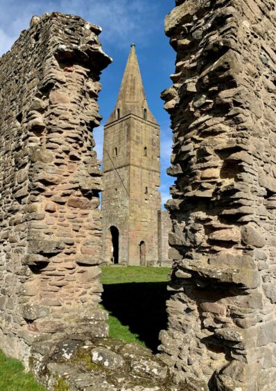
Restenneth Priory, Forfar, Angus
The marsh path to Restenneth Priory is often out of bounds in winter due to flooding, so it seemed sensible to take advantage of a spell of dry and crisp weather for unfettered access.
This impressive ruin lies to the east of Forfar and the town’s excellent path network makes it simple to include a visit in a wider circuit which also takes in the heights of Balmashanner Hill.
Some of the priory stonework dates to the 1100s although it is thought to stand on the site of an much earlier Pictish church. Robert the Bruce buried his young son John here in the 1300s.
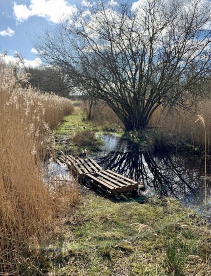
The buildings were originally erected on an island in a loch which was eventually drained in the 18th Century. The path from the north crosses the low boggy ground between a tunnel of high reeds which is regularly swamped, the water from the wetlands spilling over from either side.

Despite days of dry conditions, there was still a squelch as I made my way along, and some makeshift duckboards helped my passage over sections of standing water.
I started my walk from the centre of town, although I had one small matter to take care of first. No visit to Forfar would be complete without loading up with a bridie, so once I had made that detour it was all systems go.
There was a bit of pavement pounding at first, passing by Forfar Athletic’s Station Park and heading out north-east on a quiet minor road, then following signed paths as they led round to Lunanhead.
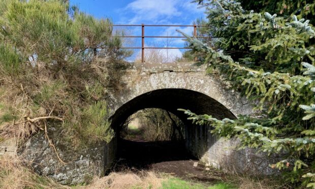
A short distance after crossing the B9134, I climbed up on to the old rail line and the path between an avenue of trees. Just before reaching a dead end at an old bridge, a path dropped left and then turned back under the bridge on to the marsh path to reach the access lane for the priory.
The next leg of the walk passed through sand and gravel pit workings, the profusion of wildfowl on the water a stark contrast to the industrial surroundings. The signs pointed the way out to the A932 and some more minor road walking, this time beside the golf course.

Further on, there was a choice of route. You can turn left along a minor branch road and then follow the path down into the village of Kingsmuir, but I decided I would rather try to make further use of the dismantled railway so turned right through a rusty metal pedestrian gate and on to a path along the walled edge of a field.
The route followed a natural curve just before an old underpass and then round to the right where I climbed up on to the open section of line. Where this ran out, a path led round field edges and into Kingsmuir.
A series of minor roads, farm lanes and paths brought me to an entrance for Balmashanner Hill where a short climb led up to the tower and viewpoint which revealed the white-capped distant hills.
I made my back downhill to the right through the woodland and then through the streets to the car park. Alternatively, you can return by a signed path which goes through the pristine green of Reid Park.
ROUTE
1. Head up Victoria Street and turn left along North Street. Continue past Station Park and follow road through industrial estate then left up Suttieside Road.
2. At North Whitehills, turn right (signed for Lunanhead), then double back at next path junction to head north-east. Path turns right then swings right into Lunanhead.
3. Walk through hamlet to B9134, cross and take next right down towards Lunan Well. After passing through old viaduct, turn sharp left and climb on to tree-lined rail line path.
4. Just before rail bridge, leave path to left then turn right under bridge on to marsh path and follow to Priory access entrance on left.
5. After visiting Priory, return to path and turn left heading out to B9113. Cross and go through metal gate opposite (signed) to pass sand and gravel pits before following signed route left.
6. Go through metal gate to reach A932 and head straight across on road past golf course. When you reach turning on left for minor road, turn right instead through rusty pedestrian gate on to path alongside field.
7. Swing left in front of old rail underpass and follow path round to next one. Go through then climb left to walk along old rail bed. When this runs out, keep right on path along field edge until emerging on B9128 in Kingsmuir.
8. Cross road and follow access path to Kingston (signed). This goes between new-build houses then farm lane. Turn right on to path at end of lane to reach minor road.
9. Head up to Pitreuchie then across to Hillside and entrance for Balmashanner Hill. Turn right along to viewpoint then follow path down through woods to reach Lour Road. Turn left and walk down through streets to start.
INFORMATION
Distance: 15km/9.4miles
Ascent: 198m/650ft
Time: 4-5 hours
Grading: Fine circuit around the Forfar Path Network for all ages and abilities, some sections on minor roads and pavements. Muddy in places, rough in others, and the marsh path to Priory may be impassible at times due to flooding. Dogs under strict control around farm livestock.
Start/finish: East Greens car park, Forfar (Grid ref: NO 456509).
Map: Ordnance Survey 1:50,000 Landranger Map 54 (Dundee & Montrose); Ordnance Survey 1:25,000 Explorer sheet 382.
Tourist Information: Tourist Information: VisitScotland, Dundee iCentre, 16 City Square, Dundee, DD1 3BG (Tel 01382 527527).
Public transport: Regular bus services to Forfar.


Conversation