Woodlands of Ladybank, Fife
Lovers of woodland walking will be delighted to dip into the arboreal selection box that surrounds the Fife village of Ladybank.
This pleasant clockwise circuit will while away a few hours as it passes through half-a-dozen separate sections of woodland all linked by a well-signed core path network.
The walk starts from the railway station, heading west along Commercial Road into Monkstown, a name which reflects the town’s origins. Around 700 years ago, the area was a vast marshland where monks from Lindores Abbey were given permission to cut peat.
You could spend hours here
They named it Our Lady’s Bog, and over time this was shortened to Ladybog. When a railway junction and depot were constructed nearby in the 1840s, it was given the rather more genteel epiphet of Ladybank and the settlement that grew up around it followed suit.

A small wooden bridge gives access to Monkstown Wood, the first woodland section of the walk, with the path eventually heading out on to the busy A92. On the opposite side of the road, take the signed path along the edge of the trees rather than a tempting one to the left – this quickly becomes impassable with fallen trees.
A short stretch of road walking leads into Heatherhall Wood. You could spend hours here on the maze of paths which head off in all directions, but following the line of the water course, the Rossie Drain, is the best option. The familiar shape of East Lomond is a constant presence through the trees.
At the edge of the wood, the path turns right then twists its way between sections of fallen trees and reparation work – every time you think the way is blocked, a solution appears – before reaching an exit to the north-east.
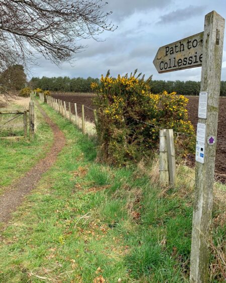
Another bit of quiet road walking follows, leading to a crossroads at Charlottetown and just a little further on a sign (Collessie) points the way towards another small wood. There are two small lochs hidden among the trees, a peaceful haven for waterfowl, the occupants on this occasion being swans, ducks, moorhen and a heron.

The undergrowth on the western shores makes it slightly awkward to trace a route. There is a very wet, often flooded, path along the eastern side if you fancy a closer look.
Surprise
There was a surprise in store just around the corner, the water theme continuing as I had to negotiate deep, standing water under the rail bridge. With no other way onward, I took the plunge on tiptoe and managed to emerge relatively unsoaked.
The path through the next section of woodland ran parallel first with rail line, then with the A92 as it took a sharp turn left. Another careful crossing and it was into the North Annsmuir segment, where the path swung by the golf course and then into the southern part of the woods.
The final leg offered a variety of track and path options to reach the grassy path which swings round to reach the level crossing and the short walk back to the station.
ROUTE
1. From rail station, head west on Commercial Road. After last house, turn right over wooden bridge into Monkstown Wood.
2. Turn left at first path junction. After passing car park and cairn this swings north. Follow to edge of wood then out to A92.
3. Cross and take core path (signed Edenstown) on opposite side (do not use path to left as it becomes impassable with fallen trees). At end of path, turn left along road past houses then right into Heatherhall Wood at parking area.
4. Take path on left into trees and before reaching large parking and picnic area turn right. Ignore all right turns and stay on this line or use parallel paths in trees to left to reach edge of woods.
5. Follow path right and right again, then go left for around 1km to emerge at minor road. Turn right and walk along to Charlottetown.
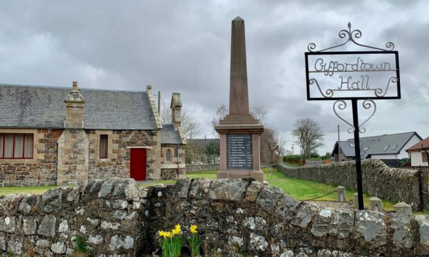
6. Go straight across, and with Giffordtown Hall on your left, follow minor road ahead. When it curves sharp right, turn left (signed Collessie) on path between fields.
7. Just before reaching road, turn right into Cairnfield Muir woods and follow to exit at north corner. NB: You can take right branch at split which leads to two ponds. It’s also possible to follow very wet path along eastern shores for closer look at lochs.
8. Once back at corner exit, turn right under rail bridge then right into woodland. Follow paths parallel to railway, then go left on another and follow until it turns right to main road.
9. Cross with care to golf course entrance and turn left into North Annsmuir Woods. Follow round right to emerge from woods at corner of course and use track alongside course to reach South Annsmuir Woods.
10. Pass barrier gate taking forest path south. At junction, go straight ahead on narrow path through trees then right on grassy path at edge of wood and continue to level crossing. Go over and turn left back to station.
INFORMATION
Distance: 12km/7.5miles
Ascent: 30m/100ft
Time: 3-4 hours
Grading: Clockwise low-level wander through several sections of woodland around Ladybank, some walking on quiet minor roads, two busy crossings. Can be muddy, waterlogged in places, good footwear advised. Dogs under close control around farm livestock.
Start/finish: Ladybank rail station (Grid ref: NO 306096), parking available in quiet side streets.
Map: Ordnance Survey 1:50,000 Landranger Map 59 (St Andrews); Ordnance Survey 1:25,000 Explorer sheet 371.
Tourist Information: VisitScotland, St Andrews iCentre, 70 Market Street, St Andrews, KY16 9NU (Tel 01334 472021).
Public transport: Train and bus services to Ladybank.


Conversation