Calendar An icon of a desk calendar. Cancel An icon of a circle with a diagonal line across. Caret An icon of a block arrow pointing to the right. Email An icon of a paper envelope. Facebook An icon of the Facebook "f" mark. Google An icon of the Google "G" mark. Linked In An icon of the Linked In "in" mark. Logout An icon representing logout. Profile An icon that resembles human head and shoulders. Telephone An icon of a traditional telephone receiver. Tick An icon of a tick mark. Is Public An icon of a human eye and eyelashes. Is Not Public An icon of a human eye and eyelashes with a diagonal line through it. Pause Icon A two-lined pause icon for stopping interactions. Quote Mark A opening quote mark. Quote Mark A closing quote mark. Arrow An icon of an arrow. Folder An icon of a paper folder. Breaking An icon of an exclamation mark on a circular background. Camera An icon of a digital camera. Caret An icon of a caret arrow. Clock An icon of a clock face. Close An icon of the an X shape. Close Icon An icon used to represent where to interact to collapse or dismiss a component Comment An icon of a speech bubble. Comments An icon of a speech bubble, denoting user comments. Comments An icon of a speech bubble, denoting user comments. Ellipsis An icon of 3 horizontal dots. Envelope An icon of a paper envelope. Facebook An icon of a facebook f logo. Camera An icon of a digital camera. Home An icon of a house. Instagram An icon of the Instagram logo. LinkedIn An icon of the LinkedIn logo. Magnifying Glass An icon of a magnifying glass. Search Icon A magnifying glass icon that is used to represent the function of searching. Menu An icon of 3 horizontal lines. Hamburger Menu Icon An icon used to represent a collapsed menu. Next An icon of an arrow pointing to the right. Notice An explanation mark centred inside a circle. Previous An icon of an arrow pointing to the left. Rating An icon of a star. Tag An icon of a tag. Twitter An icon of the Twitter logo. Video Camera An icon of a video camera shape. Speech Bubble Icon A icon displaying a speech bubble WhatsApp An icon of the WhatsApp logo. Information An icon of an information logo. Plus A mathematical 'plus' symbol. Duration An icon indicating Time. Success Tick An icon of a green tick. Success Tick Timeout An icon of a greyed out success tick. Loading Spinner An icon of a loading spinner. Facebook Messenger An icon of the facebook messenger app logo. Facebook An icon of a facebook f logo. Facebook Messenger An icon of the Twitter app logo. LinkedIn An icon of the LinkedIn logo. WhatsApp Messenger An icon of the Whatsapp messenger app logo. Email An icon of an mail envelope. Copy link A decentered black square over a white square.

‘Heavy wintry showers’ predicted in Perthshire into Friday

Snow on the A9.
Snow on the A9.

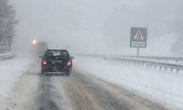
Parts of Tayside will be hit by “heavy wintry showers” until Friday, say forecasters.

A Met Office yellow warning for snow and ice which is in place for the region – and neighbouring Fife – has been extended and is now effective from 9.35am on Thursday until 10am on Friday.

It comes after roads were closed in Perthshire as a result of heavy snowfall on Wednesday.

The Met Office said the highest routes within the warning area – which includes the Highlands, Western Isles and Strathclyde – could experience as much as 7.9in of snow overnight into Friday, with “temporary blizzard conditions” possible in places.

The worst of the wintry weather is not predicted to make it as far east as Dundee, Perth and much of Fife and Angus. However lower levels are expected to endure a mixture of rain, sleet, hail and ice.

The A93 Braemar to Perth road at the Spittal of Glenshee remains closed this morning, however gritters are working to reopen the route.

A Met Office statement said: “Heavy wintry showers will lead to some lying snow, particularly over high ground, through Thursday and overnight into Friday morning. Ice is also expected to form widely overnight into Friday.

“Some roads and railways likely to be affected with longer journey times by road, bus and train services as well as some injuries from slips and falls on icy surfaces.

“With strong winds drifting snow is also possible with temporary blizzard conditions possible in showers. Conditions are expected to improve overnight into Friday with showers becoming less frequent but then ice will become the main hazard.

“This is an update to extend the warning into Friday morning and increase the likelihood of impacts being seen.”

The Met Office’s chief forecaster said: “Frequent showers will push across northwest Scotland falling as snow, mainly above 200m (356ft).

“Snow could build up to give 10-20 cm (3.9in-7.9in) over the highest routes in parts of northern Argyll, Lochaber, Wester Ross and Easter Ross through Thursday and overnight into Friday with strong winds leading to some drifting and also temporary blizzard conditions.

“At lower levels showers are more likely to fall as a mixture of rain, sleet and hail potentially washing off any treatment with surfaces turning icy, particularly overnight into Friday.”