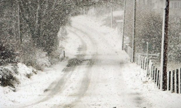
Forecasters have warned that Scotland will be battered by gale-force winds and “blizzard conditions” later this week.
Storm Caroline is predicted to move into the country on Thursday between 8am and midnight, bringing winds of up to 80mph to the Highlands, Western Isles, Strathclyde and Grampian – with a Met Office yellow warning for wind issued for the regions.
This will be followed by a day of “increasingly frequent” snow showers across Scotland which will affect most of the country, including parts of Tayside.
A Met Office yellow warning for snow and ice has been issued for Central, Tayside and Fife, Grampian, the Highlands, the Western Isles, the Northern Isles, Strathclyde, the Borders and south-west Scotland. It will be in force from Friday morning until Saturday at 6pm.
Some 7.8in of snow could land on higher ground, with about 2in possible at lower levels.
However Dundee and much of Fife looks set to miss the worst of the snow once again.
Travel disruption is predicted across Thursday, Friday and Saturday.
A Met Office statement said: “Snow showers are expected to become increasingly frequent over northern Scotland late on Thursday and are expected across many other parts of Scotland, Northern Ireland, Wales and western England on Friday.
“2-5 cm of snow is likely for some, with 10-20 cm possible over high ground, mainly Scotland, Northern Ireland and Wales.
“Icy surfaces are also likely to be an additional hazard, especially overnight. Strong northwest winds may cause drifting of the snow in places with blizzard conditions possible at times across northern Scotland.
“The heaviest and most frequent of the snow showers will progressively become confined to north-east Scotland during Saturday.
“Some roads and railways likely to be affected with longer journey times by road, bus and for train services. Probably some icy patches on some untreated roads, pavements and cycle paths. Some injuries from slips and falls on icy and snowy surfaces.”
Warning of Storm Caroline, the Met Office’s chief forecaster said: “The strongest winds will reach the northwest early on Thursday, extending to the north-east and Northern Isles in the afternoon.
#StormCaroline has been officially named by the Met Office. High winds are expected to affect northern Scotland on Thursday. Warnings issued, stay #weatheraware pic.twitter.com/J7nZOEFhYr
— Met Office (@metoffice) December 5, 2017
“Winds will start to ease in the west by then with the strongest of the winds becoming confined to the Northern Isles in the evening. Snow showers will turn increasingly frequent and heavy across northern Scotland during the evening.”