Tayside and Fife is “right in the track” of Storm Ali, which is forecast to batter Scotland with 75mph winds and cause widespread travel disruption on Wednesday.
Forecasters say the likelihood of the blustery conditions causing injuries, damage to buildings, power cuts and trees to fall is “quite significant” in Dundee and the surrounding area.
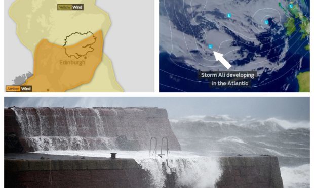
On Tuesday a Met Office amber warning for wind, effective from 8am until 5pm on Wednesday, was issued for Tayside and Fife and neighbouring Grampian. A second yellow one remains in place from 6am until 10pm.
Traffic Scotland said restrictions affecting high-sided vehicles and double-decker buses will be highly likely on the Tay Road, Friarton and Forth Road bridges on Wednesday afternoon.
It comes as the Scottish Government warned the weather could result in cancelled flights, trains and ferries across the country, with police advising people to think ahead before they travel.
Ali, the first named storm of the season, is being caused by a maritime polar air mass moving into the country from the Atlantic. It could bring gusts of up to 80mph to parts of western Scotland.
Met Office spokesman Richard Miles said: “Dundee is right in the track of the amber warning, it does affect the city and the surrounding area. We are looking at gusts of up to 75mph, even inland.
“The possibility of flying debris and injury from that is quite significant, probably some damage to buildings and cancellations in terms of transport services, and possibly power cuts.
“There will also be heavy, squally rain, but because it is moving fast it won’t be lingering that long.
“The wind will be a problem all day. You are looking at strong winds of about 75mph inland and on exposed coasts we are looking at 80mph, that is more in the western side of Scotland.
“It is not (a result of) the tropical influence with Storm Helene. It is a maritime polar air mass coming from the Atlantic to the west.”
Met Office chief forecaster Laura Paterson said: “As this is the first spell of very strong winds of the season, and given that most trees are still in full leaf, we are likely to see some dangerous conditions with falling trees and flying branches and other debris likely.
“Strong winds will be accompanied by heavy, squally showers.”
The Scottish Environment Protection Agency (Sepa) is also monitoring the weather conditions and warned locals to “remain vigilant”.
The organisation’s hydrology duty manager Mark McLaughlin said: “Sepa is continuing to monitor coastal conditions over the coming days, and will provide further updates as appropriate.”
Scottish cabinet secretary for transport, infrastructure and connectivity Michael Matheson said: “There is the potential for disruption on the roads, especially on bridges, and people should check the latest information before they set off, drive to the conditions and follow police advice.
“Motorists should check Traffic Scotland before they set off to make sure that their route is available.”
Police Scotland’s head of road policing, Chief Superintendent Stewart Carle, said: “If you are driving a vehicle which may be vulnerable to being blown over in such conditions along exposed routes including bridges, please exercise additional caution and plan your route to avoid exposed areas or consider cancelling your journey until conditions improve.”