Calendar An icon of a desk calendar. Cancel An icon of a circle with a diagonal line across. Caret An icon of a block arrow pointing to the right. Email An icon of a paper envelope. Facebook An icon of the Facebook "f" mark. Google An icon of the Google "G" mark. Linked In An icon of the Linked In "in" mark. Logout An icon representing logout. Profile An icon that resembles human head and shoulders. Telephone An icon of a traditional telephone receiver. Tick An icon of a tick mark. Is Public An icon of a human eye and eyelashes. Is Not Public An icon of a human eye and eyelashes with a diagonal line through it. Pause Icon A two-lined pause icon for stopping interactions. Quote Mark A opening quote mark. Quote Mark A closing quote mark. Arrow An icon of an arrow. Folder An icon of a paper folder. Breaking An icon of an exclamation mark on a circular background. Camera An icon of a digital camera. Caret An icon of a caret arrow. Clock An icon of a clock face. Close An icon of the an X shape. Close Icon An icon used to represent where to interact to collapse or dismiss a component Comment An icon of a speech bubble. Comments An icon of a speech bubble, denoting user comments. Comments An icon of a speech bubble, denoting user comments. Ellipsis An icon of 3 horizontal dots. Envelope An icon of a paper envelope. Facebook An icon of a facebook f logo. Camera An icon of a digital camera. Home An icon of a house. Instagram An icon of the Instagram logo. LinkedIn An icon of the LinkedIn logo. Magnifying Glass An icon of a magnifying glass. Search Icon A magnifying glass icon that is used to represent the function of searching. Menu An icon of 3 horizontal lines. Hamburger Menu Icon An icon used to represent a collapsed menu. Next An icon of an arrow pointing to the right. Notice An explanation mark centred inside a circle. Previous An icon of an arrow pointing to the left. Rating An icon of a star. Tag An icon of a tag. Twitter An icon of the Twitter logo. Video Camera An icon of a video camera shape. Speech Bubble Icon A icon displaying a speech bubble WhatsApp An icon of the WhatsApp logo. Information An icon of an information logo. Plus A mathematical 'plus' symbol. Duration An icon indicating Time. Success Tick An icon of a green tick. Success Tick Timeout An icon of a greyed out success tick. Loading Spinner An icon of a loading spinner. Facebook Messenger An icon of the facebook messenger app logo. Facebook An icon of a facebook f logo. Facebook Messenger An icon of the Twitter app logo. LinkedIn An icon of the LinkedIn logo. WhatsApp Messenger An icon of the Whatsapp messenger app logo. Email An icon of an mail envelope. Copy link A decentered black square over a white square.

Weather warnings issued for Tayside and Fife with storm-force winds and heavy rain due to hit

Stormy weather is predicted across Fife. Image: Supplied.

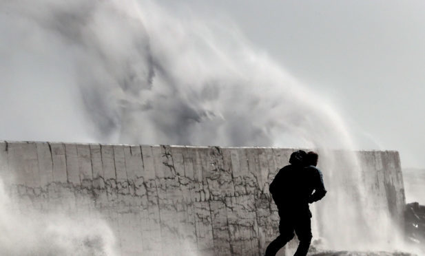
Forecasters have warned locals to prepare for storm-force winds, heavy rain and flooding across Tayside and Fife later this week.

A yellow weather warning has been issued by the Met Office for Friday at noon until Saturday at 6pm.

Gusts of up to 70mph could batter parts of Scotland, with winds of 50mph expected “widely”.

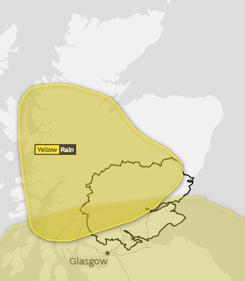
A separate yellow warning for heavy rain, which could combine with melting snow and lead to flooding, will be in place across Courier country from 9am until 3pm on Friday.

The stormy weather is being caused by an area of low pressure which is moving across the UK.

How the wind and rain warnings are affecting Tayside and Fife.

The Met Office says there will be a “spell of very strong winds” which will lead to travel disruption. Roads and air, rail and ferry services are expected to be hit.

Power cuts are possible, while Friday’s rain could lead to properties and roads being flooded.

The forecaster adds there is a “small chance of fast flowing or deep floodwater causing danger to life”.

The Met Office wind warning states: “A deep area of low pressure is expected to track across northern Britain later on Friday and through early Saturday.

“Southwesterly winds will strengthen through Friday. Gales will become widespread later on Friday, persisting well into Saturday whilst becoming more westerly.

“Whilst some places may miss the worst of the winds, inland gusts of 50mph are expected quite widely, with some places having gusts in excess of 60 mph, more especially across the north of the warning area on Saturday.

“Gusts of up to 70 mph are likely around some coasts exposed to the west or southwest.

“Winds will gradually ease on Saturday, with the strongest winds becoming confined to Scotland on Saturday afternoon.

“These winds will lead to large waves affecting coasts and the possibility of waves over-topping some coastal routes, especially in the west and south of the warning area.

“In addition, bands of heavy rain sweeping eastwards on Friday in particular will present an additional hazard.”

The rain warning adds: “Rain will spread east early on Friday, gradually becoming persistent and heavy, especially over high ground.

“Rain will clear to the east in the evening, but with frequent heavy showers following.

“Expect 20-30 mm of rain widely across the area, with up to 60mm over high ground. Melting of snow will contribute to the risk of flooding.”