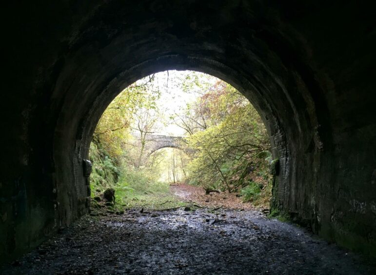
Glenfarg rail tunnels, Perth & Kinross
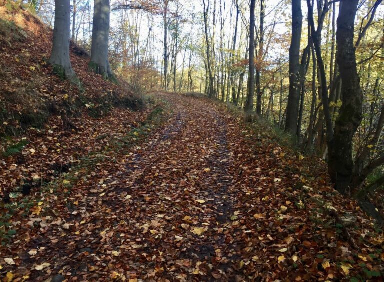
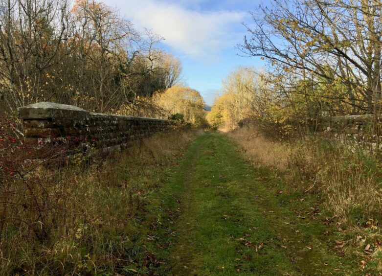
There’s always a great joy in walking along old railway lines, peaceful, grassy, tree-lined passages that have long returned to nature.
One of the finest examples is in Glen Farg, south of Perth. The big attraction here – if you aren’t afraid of the dark or suffer from claustrophobia that is – is the two long tunnels which have to be negotiated.
Both are around 500 metres long: the northern one lies on a curve so once inside the darkness is more absolute for a while. The southern tunnel is straighter, so you can just make out the distant pinprick of light at the other end. Needless to say, neither should be attempted without decent torchlight.
They were part of the North British Railway line, opened in 1890 at the same time as the completion of the Forth Bridge, to provide a direct link from Edinburgh to Perth. The Glenfarg stretch was on a notoriously steep gradient. Despite escaping the Beeching cuts of the 1960s, the line was closed in 1970 to allow the track bed to be used during construction of the M90.
The route can be done in either direction. It can also be started from a layby to the south-west on the B996 where there is room for a couple of cars.
This avoids the need for walking along the busy A912, unavoidable if starting from the Bein Inn. There is no pavement or verge, and there are blind bends on the road. Great care is needed.
It is mercifully brief, though, and we were soon across the waters of the Farg and a high rail bridge following a delightful track through a copper carpet of fallen leaves and then down to the old rail line.
The first tunnel was a bit of a shock to the system, our steps slowing appreciably as we entered the darkness. The floor was dry, although there was the occasional surprise mis-step when we hit a slight dip, and we were constantly on the alert for trip hazards.
We emerged back into the light, continuing to chug along at a good pace until reaching a minor road where we turned left and headed uphill, crossing one motorway bridge, then further on back over another to head towards Meikle Fieldie farm.
A grass track led down to a double set of gates that had to be crossed for access to a woodland path leading down to the B996 which runs parallel with the rail line.
The track leading to the second tunnel entrance was blocked by a bulldozed earth barrier, but a step to the right provided a simple way past and then we were in the darkness again.
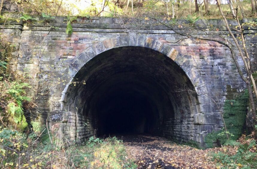
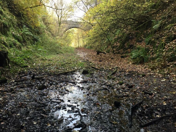
There was the curiosity of the remains of what may once have been a car just inside the entrance, as if time had melted it beyond all recognition. The floor was again dry but we exited into a quagmire, the track a morass of thick, cloying mud with old, blackened sleepers sticking out.
We passed under the high bridge we had crossed at the start of the walk, then turned sharp left at a junction to re-cross the bridge and brave the short road walk to the finish.
ROUTE
1. From hotel car park, walk north along B912 for short distance to reach track on left, opposite sign for Binn Eco Park. This is a busy road with no verges so great care is needed.
2. Cross River Farg then rail bridge and follow track round to right. Take branch heading downhill on right through wooden gate to join line of rail track.
3. Head north on tree-lined track to northern tunnel. Once out other side, stay on track bed, passing over bridge, to reach minor road.
4. Turn left and head steadily uphill to cross M-way. Stay with this minor road to high point then take track on left (Meikle Fieldie) crossing motorway bridge.
5. Swing right to follow road/track towards farm. Opposite first shed, go through metal gate and head downhill. This track curves left at first and when it starts to swing right, leave it and go straight ahead to double set of gates giving access to woodland path alongside burn.
6. Follow this to exit wood at B996. Turn left and walk along road for short distance running parallel with rail line to reach opening on right (don’t be tempted to go through fence on to rail line earlier as exit is blocked).
7. Turn left on rail bed to entrance of southern tunnel. The track may appear to be blocked by an earth barrier, but it is simple to step over fence to right of metal gates.
8. Exit tunnel into very muddy ground and pass under bridge crossed at start of walk. Track then gently rises to junction. Turn left taking incoming track slanting back uphill, cross bridge and then carefully retrace steps back up A912 to hotel.
INFORMATION
Distance: 8.5km/4.5miles
Ascent: 200m/650ft
Time: 2.5-4 hours
Grading: Pleasant circuit on old rail track bed and woodland paths, some minor roads and short section on busy road which needs extreme care. Two long, dark tunnels where good torches essential. Suitable for most abilities: older children will love it but it may be too much for younger ones. Very wet and muddy in places, good footwear recommended.
Start/finish: Bein Inn car park, please enquire at reception for permission to park, refundable deposit may be required (Grid ref: NO 037485).
Map: Ordnance Survey 1:50,000 Landranger Map 58 (Perth & Alloa); Ordnance Survey 1:25,000 Explorer sheet 369.
Tourist Information: VisitScotland, Perth iCentre, 45 High Street, Perth, PH1 5TJ (Tel 01738 450600).
Public transport: None to start point.