Schiehallion, Loch Rannoch, Perth & Kinross
I’ve long regarded Schiehallion as a winter mountain, one to be savoured on quieter days when the slopes are blanketed in white and there’s a satisfying crunch underfoot.
This lone peak has suffered over the years due to its popularity, and I tend to avoid the busier times. It’s one of the ‘honeypot’ Munros, a relatively simple route that offers great rewards, an attractive proposition for walkers for all abilities.
Even when I first climbed it more than 30 years ago, the signs were there: the path was a quagmire in places due to the passage of so many boots, and the natural inclination of many to try and avoid the worst sections meant wider damage.

That problem was addressed after the mountain was part-bought by the John Muir Trust in 1999. A new, more robust path was built which takes a more meandering line on to the ridge and then weaves its way up into the higher reaches.
More recently, the mountain was again at the centre of controversy, this time due to parking problems. When lockdown ended but restrictions were still in place, visitor numbers sky-rocketed and the Braes of Foss car park simply couldn’t cope. Many who couldn’t find a space – and there were many – parked along the verges of the single-track road, causing access headaches.
I had given Schiehallion a wide berth for a couple of years, but recently decided things had calmed down enough to allow a hassle-free revisit. Even then, I thought it prudent to avoid the rush hours, so I arrived at a deserted Braes of Foss around 7pm.
It was interesting to see that the overcrowding problem has since been addressed with the creation of a large overspill parking area a little further east.
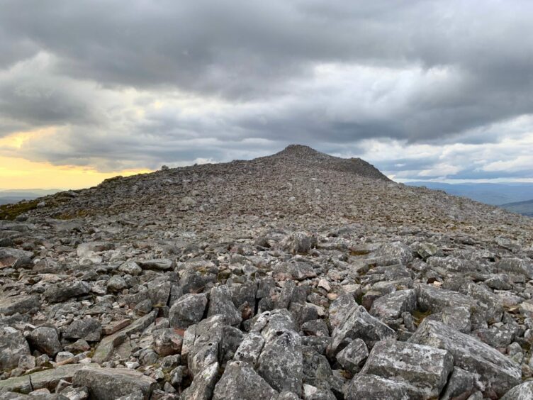
Schiehallion is a fine mountain for those starting out on their Munros journey, and on a clear day, route finding is not a problem, the well-made path guiding you up the east ridge. Higher up, a series of cairns provides guidance through the extensive boulder field, but it can be vague at times and it in mist it would be easy to lose the line in places.

Although it is regarded as one of the easier hills, I’m reluctant to describe any 3,000-ft plus hill as ‘easy’: the unpredictability of the Scottish weather can turn what seems a straightforward walk into an ordeal very quickly, especially at height.
Descending in deep snow a few years back, I managed to come off the line of the path despite having reasonable visibility. On another occasion, while filming a night ascent sequence for the Adventure Show, we were forced to take shelter for a few hours on the side of the mountain in temperatures of minus 10 while we waited for the sun to rise to get the summit shots.

Even on this latest outing, the mist swallowed the landscape for a short time on the descent forcing me to double check my passage through the boulders.
The ascent had been fast, the path weaving uphill with the views opening out more and more with every step in the dramatic evening light. Once over the lip of the ridge, the rocky cone came into view. Now there was just the small matter of getting through the boulder chaos.
There are still erosion problems in certain areas, and a series of signs directed me right towards a zig-zag scree path which tinkled like glass as it led through the bigger boulders. The rocks just kept getting bigger and bigger with increasing height until it became easier to hop from one to another rather than find a way through.
The small cairn that crowns the rocky pavement of the short summit ridge seems insignificant compared to some of those on the way up, but it is irrelevant when the panorama is this spectacular.

Loch Rannoch was a long silver sheet capped with the gold of the setting sun lighting the sky at its far end, while towering clouds looked threatening yet benign at the same time.
The descent took almost as long as the ascent, the boulder route requiring a cautious touch. It would be too easy to snap an ankle here.
With the light fading, the horizon became a blazing red as I dropped under the watchful eyes of curious deer reduced to silhouettes above me.
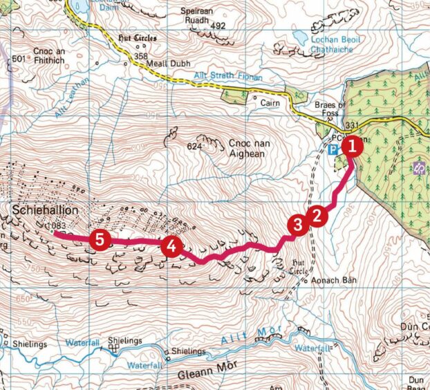
ROUTE
1. Exit car park at far end, turn right and go through pedestrian gate to pick up path which goes south-east at first then east.
2. Cross track and pass through another larger gate in fence to reach foot of east ridge.
3. Path now weaves steadily uphill to flatter area at top of ridge.
4. Terrain ahead is much rougher but after passing over minor rise, series of cairns helps ease the way through boulder field.
5. Final section is through huge boulders and care is needed before summit cairn is reached. Return by reversing the route.
INFORMATION
Distance: 9km/6miles
Ascent: 760m/2493ft
Time: 4-6 hours
Grading: Steep, sustained ascent on a fine path to a popular Munro for those with good level of hill fitness. Route-finding is mostly simple in clear conditions, but walkers should be well-equipped and have sufficient navigation skills to cope with all weathers. Great care is needed in the boulder field higher up.
Start/finish: Braes of Foss car park (Grid ref: NN 753556). Charges apply. There is also now an overspill car park about 500m further east.
Map: Ordnance Survey 1:50,000 Landranger Map 42 (Glen Garry & Loch Rannoch); Ordnance Survey 1:25,000 Explorer sheet OL49.
Tourist Information: VisitScotland, Pitlochry iCentre, 22 Atholl Road, Pitlochry, PH16 5BX (Tel 01796 472215).
Public transport: None to start point.


Conversation