Sgor Buidhe, Ballater, Deeside
Visitors to Ballater are spoiled for choice when it comes to finding a decent walk. There’s something for everyone here, from the heights of majestic Lochnagar to smaller rugged hills full of character plus satisfying river and woodland circuits.
One of the finest is the Sgor Buidhe walk, an anti-clockwise route that manages to combine woodland and moorland before returning along a riverside path on the banks of the Dee.
The first thing to note is that despite being the highest point of the day, Sgor Buidhe is unnamed on most maps, just registering as a 547-metre spot in the rolling heather rises between the two lesser but named tops of Creagan Riabhach and Craig of Prony.
Starting from the smartly rebuilt old station in the centre of the village, I followed the sign for the Deeside Way then quickly turned left along a lane at a worn wooden signpost. Once across the road ahead I took the path running alongside fields and kept following the posts marked yellow to reach the Pass of Ballater road.
A short distance further on, another faded wooden sign pointed the way up a forest track. This rose steadily but never too steeply between the trees, pine at first then birch, with a constant spring chorus of birdsong.
As the track looped to the left, there were fine views of distant Morven. When the track started to turn towards a transmitter mast on the left, I cut off right on a grassier path and then right again on a muddier track heading uphill which eventually emerged on to the open moorland.
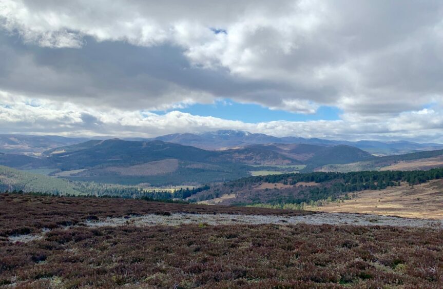
The temperature plunged dramatically, the sudden shock of coming out of the tree cover, but the consolation was a wonderful view of far-off Lochnagar, its myriad corries being gradually invaded by swirling wisps of white.
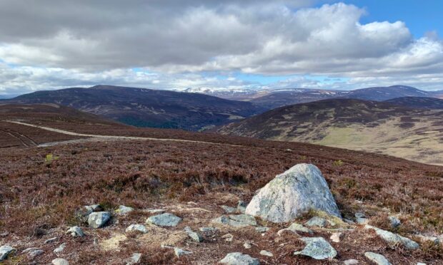
Just up to the right was the slim cairn of Creagan Riabhach with the vast bulk of Morven now more up close and personal. A line of old fence posts led across the skyline to a metal gate beside a track junction, the access to Sgor Buidhe where a white boulder was the only summit indicator.
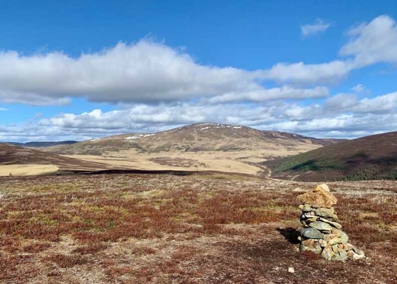
I dropped to the col with Craig of Prony where a path turns downhill to the left for those who have had enough for the day, but I kept going straight on to the two cairns on the next summit and the expansive views up Glen Gairn.
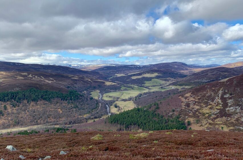
It was a short drop west down rough slopes into a straggling birch wood where I picked up a good path running south which eventually linked again with the earlier path dropping from the col. From there it was simply a case of following the signed route past farm buildings down to the Pass of Ballater road and then over the A93 to find the gap in the fence to a muddy zig-zag path leading down to a track.
I turned left, following the track past a series of little benches until the Dee came roaring in from the right to accompany me on the last part of the journey. Those who wish to linger longer can drop down to another path running above the river bank which leads to a picnic area. It’s a short hop through the streets back to the station.
ROUTE
1. Turn left through gap at far end of old station (signed: Deeside Way) then right along path. After short distance, go left at wooden signpost and head up lane between green shed and houses.
2. Cross road and go straight ahead following yellow marker posts on path alongside fields. When it emerges at houses, turn left and head up to Pass of Ballater road and turn right.
3. After passing electricity sub-station, head up track on opposite side of road (signed for Sgor Buidhe). This climbs steadily through trees then loops left. When track turns towards transmitter mast, leave it and go straight ahead on grassy track.
4. Almost immediately go left on track heading uphill and follow out of trees on to open moorland and up to slim cairn on Creagan Riabhach.
5. Follow old fence line to go through gate to Sgor Buidhe summit then continue towards Craig of Prony. You can take path heading downhill from col at this point, otherwise make short climb to twin-cairned top.
6. Drop off other side into Glen Gairn to pick up good path running through wood below to link with earlier downhill path and follow grassy track down to go through gate (signed for Ballater).
7. Pass in front of farmhouse and go down lane past houses to reach Pass of Ballater road.
8. Turn right along road to A93. Cross and turn right to reach gap in fence and take path which zig zags down to join track.
9. Turn left and walk along parallel with River Dee, then follow signposts pointing way back along lanes to left turn at junction leading out to A93 near station.
INFORMATION
Distance: 13km/8.2mls
Ascent: 420m/1378ft
Time: 3.5-4.5 hours
Grading: Fine anti-clockwise circuit on paths, forest tracks and over rolling moorland. Some street walking and a couple of road crossings which need care. Steady ascents but nothing too taxing, should suit walkers with reasonable level of fitness and older children. Muddy in places and pathless at times, sturdy footwear advised. Dogs under close control near farm livestock and due to ground nesting birds on moorland.
Start/finish: Old Royal Station, Ballater (Grid ref: NO 369959), other parking available nearby.
Map: Ordnance Survey 1:50,000 Landranger Map 37 (Strathdon & Alford) or Map 44 (Ballater & Glen Clova); Ordnance Survey 1:25,000 Explorer sheet OL59.
Tourist Information: VisitScotland, Ballater iCentre, Station Square, Ballater, AB35 5QB (Tel 01339 755306).
Public transport: Buses to Ballater on Aberdeen-Braemar (No 201) route.


Conversation