Carn Ealasaid, Cock Bridge, Aberdeenshire
There’s something rather surreal about wandering across the empty hills of The Lecht when the skiers have melted away with the snow for another year and the feeling of abandonment is everywhere.
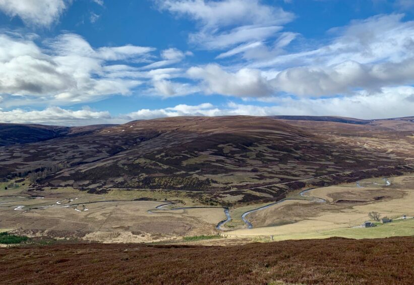
These are the Ladder Hills and there are two Corbetts in their number. To the north-east is the highest point in the range, Carn Mor, while Carn Ealasaid rules the roost to the south-west.
Carn Ealasaid translates as Elizabeth’s cairn but despite the numerous royal connections around this area, this particular Elizabeth doesn’t appear to be part of that tradition, her roots and the link to this hill remaining a mystery lost in the mists of time.
One suggestion is that the name has been misrepresented over the years and that it should correctly be called Carn Aillsichte, ‘the exaggerated mountain’, a term more befitting its expansive nature. There are several approaches to this summit, but those looking for a few hours of solitude – I never saw another soul – should enjoy the route coming in from the south which provides a fine horseshoe walk that’s never too taxing.
My starting point was the car park for Corgarff Castle at Cock Bridge on a cold morning when the air was filled with the extravagant piping of oystercatchers at their busiest, punctuated only by a lone curlew.
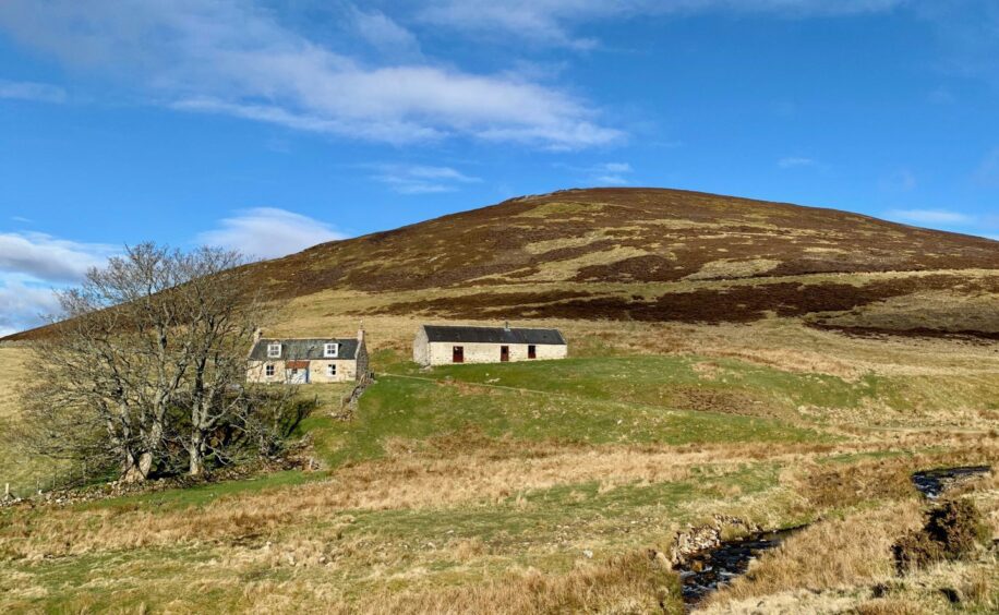
After crossing the old stone road bridge, a track turned in past the John Duff Lodge, the outdoor centre used by Kelvinside Academy, and its attendant bothy. I followed this past the ruined farmhouse of Loinherry then turned right on a rough track heading uphill.
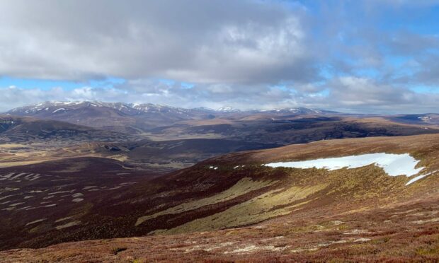
This swung back and forward on a lazy line over the slopes of Carn Vaich, views of the distant snow-streaked Cairngorms and the wide open spaces of the Don Valley one minute, the crush of rounded heather mounds to the north the next.
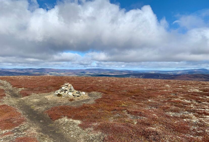
Once on higher ground the path straightened out and soon I was at the tiny cairn which sits in the midst of a wide and bare plateau.
Just beyond the cairn, the track became rougher as it turned north-east to drop to the boggy col which separates this summit from the main ski centre hill of Beinn a’ Chruinnich. To say the going is soft on the walk across would be putting it mildly, and I was just glad I had chosen a relatively dry day.
On the final approach, the sky was suddenly filled with the cacophony of hundreds of agitated birds. A massive colony of common gulls seem to have made this summit area their nesting ground, and my presence had sparked an avian typhoon.
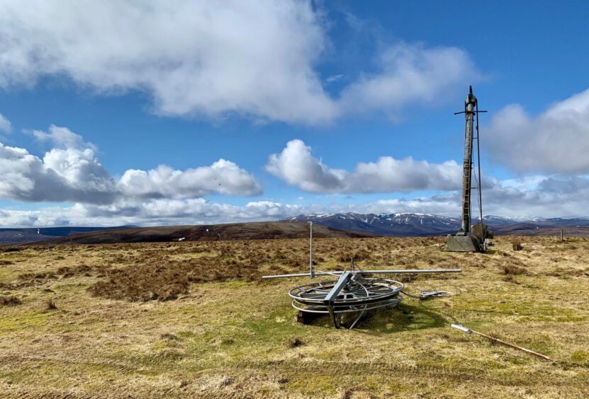
I walked through the silent tows and redundant infrastructure, heading downhill on a grassy track to Carn Mhic an Tosich where there is a viewpoint monument to the pioneers of the ski centre.
The next section is pathless and very wet and muddy, followed by a slightly awkward steep drop through deep heather to reach flatter terrain and a track that brings a more gentle angle of descent.
It felt strange to be on a hillside while traffic roared past high overhead off to the left, but soon my line reached the lively burn where I made a crossing. The track re-crossed the water further down, but the level was high and I decided a soaking at this stage wouldn’t be welcome, so I stuck to the vague path on the dry side which eventually reached the same exit point at the bridge beside Loinherry.
My car looked to be within touching distance of the track, but there’s no short cut, just a wide river blocking the way. Instead, I retraced my steps out to the A939 and then walked round to the finish line.
ROUTE
1. From parking, walk back out to A939 and turn left using grass verges. Just after crossing road bridge go left again on to track which goes behind John Duff Lodge and bothy.
2. Keep following track as it curves right then passes old farmhouse of Loinherry. A short distance beyond turn right on to hill track.
3. Stick with track as it twists up and across the slopes of Cairn Vaich and continue on to summit of Carn Ealasaid where there is a small cairn on the flat, bare plateau.
4. Descend north on track through heather to boggy col then climb again to Beinn a’ Chruinnich which is covered with ski centre equipment.
5. Follow track south past ski tows over Carn Mhic an Tosich. Beyond this, the ground becomes pathless and boggier for a while before dropping steeply through deep heather.
6. Once on flatter terrain on Carn Meadhonach pick up track which develops and drops gently to reach Burn of Loinherry.
7. Cross at stream junction, then again a little further on to emerge beside bridge at Loinherry. If you feel water is too lively, ignore the second crossing and stick to faint path along right-hand bank to reach bridge.
8. Turn left to retrace your steps along estate track back to A939 and then round to Corgarff parking.

INFORMATION
Distance: 14km/8.75mls
Ascent: 527m/1729ft
Time: 3.5-4.5 hours
Grading: High-level circuit following hill tracks and paths, with sections of rough, pathless walking. Suitable for well-equipped walkers with decent level of fitness and navigation skills. Lots of boggy ground, good footwear essential. Dogs under close control due to ground nesting birds and farm livestock.
Start/finish: Corgarff Castle parking (Grid ref: NJ 254089) access from A939 at Cock Bridge.
Map: Ordnance Survey 1:50,000 Landranger Maps 36 (Braemar & Blair Atholl) and 37 (Strathdon & Alford); Ordnance Survey 1:25,000 Explorer sheet 58.
Tourist Information: VisitScotland, Ballater iCentre, Station Square, Ballater, AB35 5QB (Tel 01339 755306).
Public transport: None to start point.


Conversation