Calendar An icon of a desk calendar. Cancel An icon of a circle with a diagonal line across. Caret An icon of a block arrow pointing to the right. Email An icon of a paper envelope. Facebook An icon of the Facebook "f" mark. Google An icon of the Google "G" mark. Linked In An icon of the Linked In "in" mark. Logout An icon representing logout. Profile An icon that resembles human head and shoulders. Telephone An icon of a traditional telephone receiver. Tick An icon of a tick mark. Is Public An icon of a human eye and eyelashes. Is Not Public An icon of a human eye and eyelashes with a diagonal line through it. Pause Icon A two-lined pause icon for stopping interactions. Quote Mark A opening quote mark. Quote Mark A closing quote mark. Arrow An icon of an arrow. Folder An icon of a paper folder. Breaking An icon of an exclamation mark on a circular background. Camera An icon of a digital camera. Caret An icon of a caret arrow. Clock An icon of a clock face. Close An icon of the an X shape. Close Icon An icon used to represent where to interact to collapse or dismiss a component Comment An icon of a speech bubble. Comments An icon of a speech bubble, denoting user comments. Comments An icon of a speech bubble, denoting user comments. Ellipsis An icon of 3 horizontal dots. Envelope An icon of a paper envelope. Facebook An icon of a facebook f logo. Camera An icon of a digital camera. Home An icon of a house. Instagram An icon of the Instagram logo. LinkedIn An icon of the LinkedIn logo. Magnifying Glass An icon of a magnifying glass. Search Icon A magnifying glass icon that is used to represent the function of searching. Menu An icon of 3 horizontal lines. Hamburger Menu Icon An icon used to represent a collapsed menu. Next An icon of an arrow pointing to the right. Notice An explanation mark centred inside a circle. Previous An icon of an arrow pointing to the left. Rating An icon of a star. Tag An icon of a tag. Twitter An icon of the Twitter logo. Video Camera An icon of a video camera shape. Speech Bubble Icon A icon displaying a speech bubble WhatsApp An icon of the WhatsApp logo. Information An icon of an information logo. Plus A mathematical 'plus' symbol. Duration An icon indicating Time. Success Tick An icon of a green tick. Success Tick Timeout An icon of a greyed out success tick. Loading Spinner An icon of a loading spinner. Facebook Messenger An icon of the facebook messenger app logo. Facebook An icon of a facebook f logo. Facebook Messenger An icon of the Twitter app logo. LinkedIn An icon of the LinkedIn logo. WhatsApp Messenger An icon of the Whatsapp messenger app logo. Email An icon of an mail envelope. Copy link A decentered black square over a white square.

Study findings to be revealed to combat £20 million flood risk to Angus coastal communities

Flooding at Carnoustie Links in December 2015

Plans are being drawn up to combat a multi-million pound flood risk to hundreds of Angus homes.

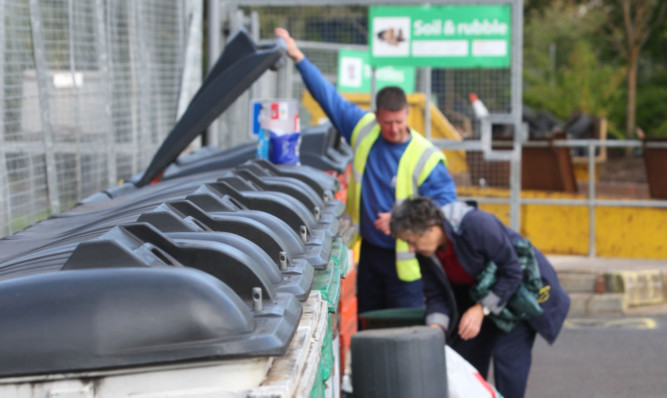
Floodwaters are already costing residents and businesses in Monifieth and Carnoustie more than a million pounds a year and Angus Council is now seeking local views on proposals being developed to protect the burghs.

The Monifieth flood risk map.

Upstream engineering works, town protection measures and an early warning scheme for local residents are under consideration.

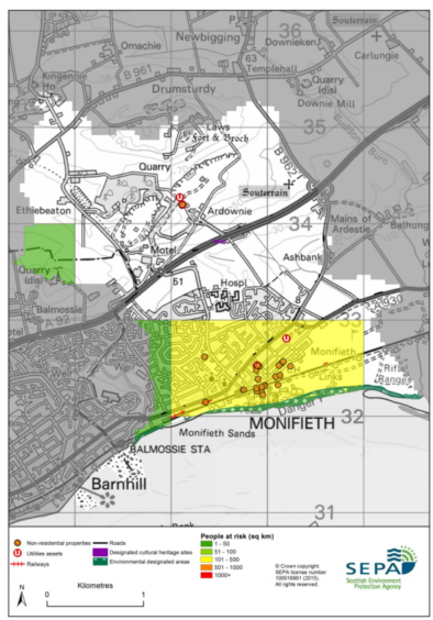
Scottish Environment Protection Agency (Sepa) data suggests 250 homes and 20 non-residential properties in Monifieth are at flood risk, with an annual average damages bill of almost £700,000.

The Carnoustie and Barry flood risk from river, coastal and surface water flooding affects around 180 residential and 30 non-residential properties, with an annual bill running to almost £500,000.

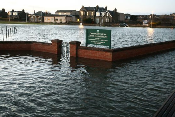
In Carnoustie, the Barry Burn and Lochty Burn present the major flood risk and have led to the town’s championship golf course and Links Parade area being flooded in the past during storm periods.

Studies have suggested the potential impacts from serious flood events in the two communities could extend beyond £20m.

The latest development is part of the Tay Estuary and Montrose Basin Flood Risk Management Plan, which identifies 19 areas potentially vulnerable to flood risk across Angus, totalling 3,490 residential and 1,210 non-residential properties.

The estimated annual average damage of those flood risks is more than £13m.

The plan covers the first implementation cycle in the period to 2022 and an Angus Council spokesperson said they hoped local residents would turn out for the upcoming consultation events.

“We and our consultant, JBA Consulting, are seeking views on our work to date.”

The public drop-ins will be held in Carnoustie library on August 12  and Monifieth Library the following day, each session running from 10.30 to 4pm.

“The project has looked at the risk of flooding from the Barry Burn, Waterybutts ditch and Lochty Burn in Carnoustie, as well as the Monifieth Burn in Monifieth,” the spokesperson added.

“We have considered solutions to reduce the risk to the community and lessen the impact that flood events might have.

“These options include engineering works either upstream or within the towns but they also include smaller scale measures to help reduce the size of floods and to inform the community when flood events are likely.

“Members of our flooding team and staff from JBA Consulting will be on hand to discuss the studies.”