Time and tide wait for no one and this is worth keeping in mind when you follow this entertaining circuit of paths and tracks along the southern banks of the Tay, says Alan Rowan.
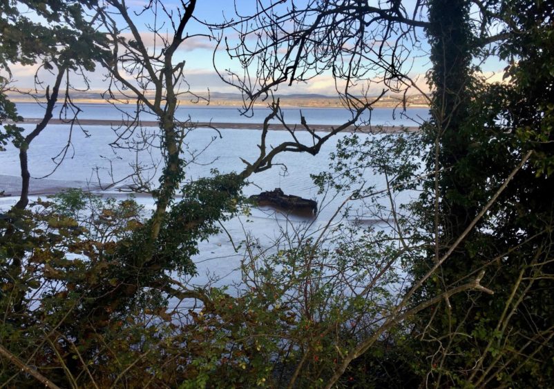
Start out at low tide and you will catch sight of the shipwreck, a dark, haunting presence stranded on the mudflats above the area known as Jock’s Hole.
This American maintenance vessel, built during the Second World War, is often referred to as the Kilburn wreck (it sits below Kilburns Farm). It’s also called the Dunoon, as that was where it was stored before being refitted in Dundee as a salvage barge. When it became surplus to requirements, it was moored at its present position but sank after being damaged by ice.
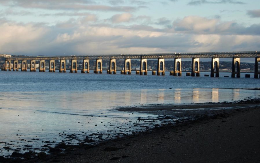
The pillars of the Tay Rail Bridge glistened like gold towers in the early sun, the view across the still waters to The Law flawless. Only the noise of the wading birds on the flats broke the silence.
Passing the poignant memorial to the rail bridge disaster, I followed the Fife Coastal Path along the shore, through a metal gate and uphill into the fields. It was muddy underfoot due to recent rains and the passage of Highland cattle.
After passing through another metal gate and dropping downhill, the wreck comes into view through the trees. With care, you can scramble down to the shore for a closer look.
The path crosses a burn by a wooden bridge and then rises again on wooden steps. There are marker posts at regular intervals to keep you on track.
I spotted the white tails of deer among the trees along the next section, the path now covered with a thick russet and copper blanket of fallen leaves. Overhead, there was the regular sight of black arrowheads of geese.
Emerging from the trees, I dropped to Balmerino and followed the markers along the front of a row of white cottages, eventually reaching the road which heads up into the village.
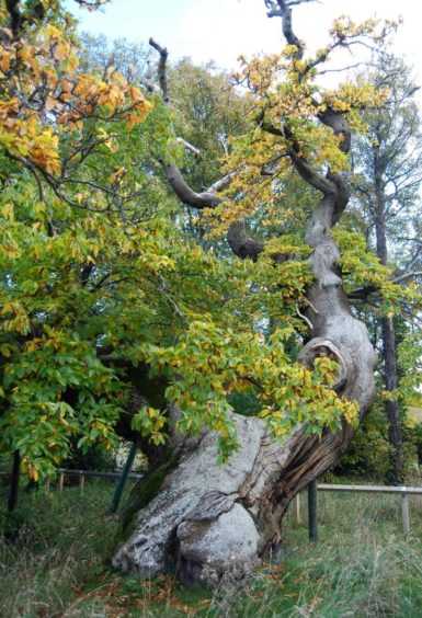
There is a small parking area, handy for those who wish to do the route by halves. You can start from here and do only the western loop of the circuit, or stop and return to Wormit. I decided to make the small detour to the ruins of the abbey and the magnificent 400-year-old Spanish Chestnut tree.
There’s no need to head back to the coastal path sign; simply cross the road from the abbey and go through a yard to pick up a path back into woodland. This winds for more than two kilometres gently through the trees and crossing a series of wooden bridges before swinging left to emerge at a track beside a beech hedge.
From the top of this field, I turned left on to a farm track, then further on left and left again at a bus shelter to go back into Balmerino, but instead of heading to the shore, I turned right between two houses and followed the road past a cemetery then round houses at Kirkton into a wood.
The going was extremely boggy in places and it needed some nifty footwork to avoid the worst. A metal farm gate allows access to a field and then a track which takes you to Peacemill Farm. New signage directs you around the farm along field edges until you swing round to see the rail bridge guiding you back to the finish line.
Route:
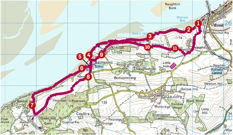
1. Leave car park heading west on Fife Coastal Path, passing Tay Rail Bridge disaster memorial, to signpost for Balmerino beside a wooden seal.
2. Go through metal gate and follow undulating path above a steep wooded bank to another gate. At low tide you can catch sight of a shipwreck down to your right.
3. After crossing a burn, the path winds through wooded section eventually reaching swing gate where steps lead down into Balmerino.
4. Follow signs that direct you round a row of houses on the shore. The road heads uphill through the village and a detour to Balmerino Abbey if desired.
5. If you miss out the abbey, turn right at the Fife Coastal Path signpost beside small car park. Otherwise, on leaving the abbey cross the road into a yard, heading to the right of a large storage building where you will pick up grass path.
6. This continues along edge of a field soon turning to path into woods (on right, could be easy to miss). This runs parallel with the shore, crossing series of wooden bridges, until it finally curves left to emerge from the trees.
7. Walk beside a high beech hedge, turn left at the end on to farm track and stay on it for about 2km until it meets a road.
8. Keep left, then again at a bus shelter, heading back down into Balmerino past abbey. Turn right between houses to cross a bridge and head uphill past cemetery to village of Kirkton.
9. Go first left then to crossroads near a phonebox, turn left and follow track below houses and before the next sharp bend take the path ahead into woods.
10. Follow this through woodland to reach a metal farm gate, then faint path through field to reach track passing Kilburns Farm and follow this until you reach more houses.
11. Signs now direct you round Peacehill Farm and along edges of fields back to car park.
The Lowdown:
Distance: 14km/8.75 miles
Ascent: 250m/820ft
Time: 4-6 hours
Grading: Mixture of woodland paths, farm tracks and roads, easy walking for all abilities but very muddy in places. Good footwear advised. Dogs under close control due to farm livestock.
Start/finish: Wormit Bay parking (Grid ref: NO 392260) at end of Bay Road.
Map: Ordnance Survey 1:50,000 Landranger Map 59 (St Andrews); Ordnance Survey 1:25,000 Explorer sheet 371.
Tourist Information: VisitScotland, St Andrews iCentre, 70 Market Street, St Andrews, KY16 9NU (Tel 01334 472021).
Public transport: Bus services to Wormit (77, 77B) and Balmerino (77A).


