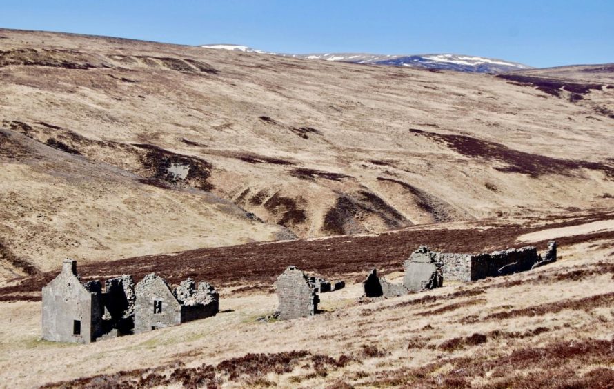
Ruighe Chail, Dalnamein Forest, Perth & Kinross
The reminders of past lives are everywhere in Scotland’s hills and glens, and it is always a poignant moment when you turn a corner and catch first sight of the ruins of a once thriving community.
The “ghost town” of Ruighe Chail in the Dalnamein Forest seems more affecting than most, possibly because of the feeling of utter desolation of the surrounding terrain despite the fact it lies just a couple of miles off the busy A9 where the traffic rushes past obliviously.
The original village dates back several centuries although the ruins that sit on the hillside are mostly from the Victorian era. Only the walls of the more substantial two-storey buildings and byres remain including those of the former Glas Choire Lodge.
The bleak landscape of bare rolling hills and empty, seemingly unending, moorland evoke images of a hard existence that is almost impossible to comprehend today. Apart from the odd bird call, there is an eerie silence and it’s no surprise to feel a ghostly atmosphere amongst these ruins.
The walk is short and simple, handy for those looking for a leg stretch to break longer journeys, but there are numerous options to extend the day.
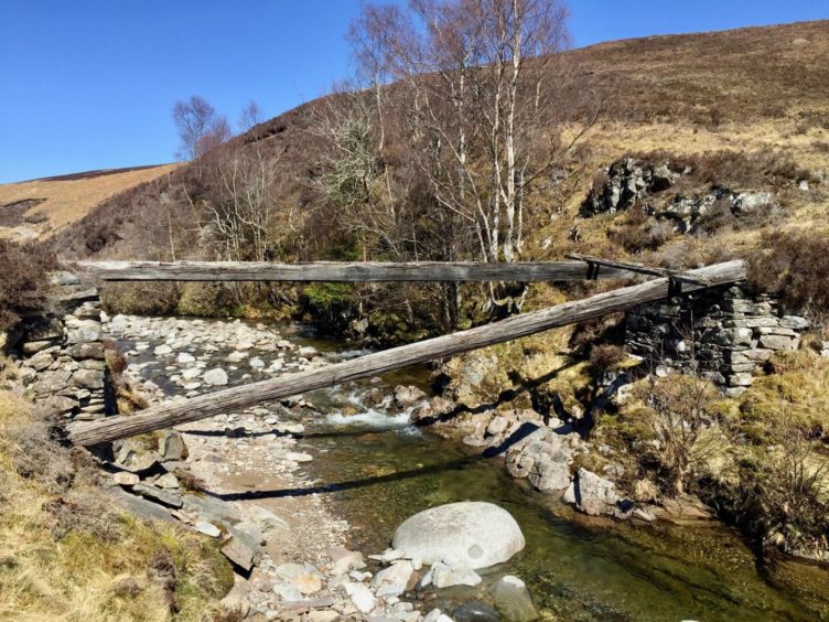
There’s a handy area to park just off the main road at Dalnamein. A lovely stone arch bridge sits nearby, the work of General Wade, although there’s some doubt as to how much remains of the original structure due to repairs and rebuilding down the years.
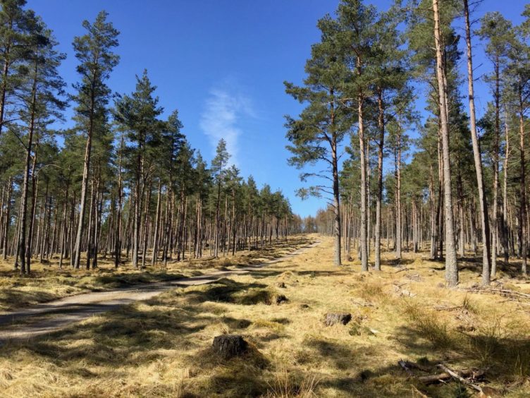
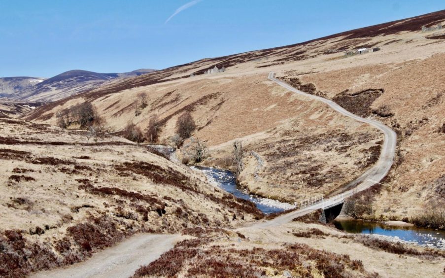
I crossed the A9 to a gated track and followed its line through a small conifer plantation to emerge on the open moor. The first sighting of the ruins comes as the track swings round a mound and dips towards a modern bridge over the waters of the Allt Glas Choire. The skeletal remains of an older bridge can be seen further downstream.
The buildings are scattered off the slope of Druim Ruighe Chail: ‘druim’ is ridge, and ‘ruighe’ is slope, but the word ‘chail’ is a little more obscure. It could be derived from ‘mothachail’ which can mean aware, sensible or observant, referring to the lofty location looking down the glen. Alternatively it could come from ‘cail’ meaning thing, so something on the slopes of a ridge. Either of these descriptions would fit the setting.
The lack of trees may suggest that ‘forest’ is a bit of a misnomer, but like so many of the deer forests, this would once have had more wide-ranging tree cover. There are a sprinkling of old buildings in the surrounding slopes in various states of disintegration, watchers’ or spotters’ bothies, their purpose being so the estate could keep an eye on the movement of deer and to deter poachers.
One of these is curiously known as Loch Treig Bothy despite being nowhere near that loch, but the name is said to come from the story of a shepherd who spotted a strange sheep in his flock and subsequently walked more than 50 miles to return the animal to its true owner.
There are old shielings tucked away in the folds of the floor in every direction and tracks running north and east offer longer walks provide the opportunity to explore. There are also plenty of hill summits to aim for, although once off the tracks the going is much tougher on some unforgiving ground, especially when wet or under snow cover.
The Corbett pairing of An Dun and A’ Chaoirnich sit to the north-west steeply above the southern narrows of the Gaick Pass but reaching them from here is a mammoth endeavour over some wild territory and they are better left for another day with an approach from Dalnacardoch.
One of the better options for those looking for some ascent may be to return to the bridge and then make the short climb west over rough ground to the top of Carn nan Seabhag before dropping down the other side and picking up a track leading back to the start.
I was happy to spend my time taking a good look around the buildings of Ruighe Chail and then sitting in the sun with my lunch reflecting on the lives and the daily struggle of those that had long vanished from these slopes before returning to the A9 and the rush of a different world.

ROUTE
1. From parking, cross busy A9 with great care, to reach gated track.
2. Follow track which goes west for a short distance then swings north through pine woods.
3. After emerging from trees, keep following track down to bridge over waters of Allt Glas Choire.
4. Cross bridge and follow winding track up to ruins.
5. Return by reversing the above route. If you feel like a longer day, there are several options to extend the walk, with tracks continuing north and east and an option to head west over the minor summit of Carn nan Seabhag to pick up another track heading south and back to start.
INFORMATION
Distance: 6km/3.5miles
Ascent: 150m/500ft
Time: 2-3 hours (Ruighe Chail ruins only)
Grading: An easy short walk of historical interest for all abilities on estate tracks. Good footwear and waterproofs recommended – exposed ground with little shelter from the elements. Extreme caution needed in crossing busy A9.
Start/finish: Parking at A9 turn-off to Dalnamein Lodge (Grid ref: NN 753697), about five miles north of Bruar.
Map: Ordnance Survey 1:50,000 Landranger Map 42 (Glen Garry & Loch Rannoch); Ordnance Survey 1:25,000 Explorer sheet 51.
Tourist Information: VisitScotland, Pitlochry iCentre, 22 Atholl Road, Pitlochry, PH16 5BX (Tel 01796 472215)..
Public transport: None to start point.


