
Forth Bridges walk, Inverkeithing, Fife
There’s always something special about a rail journey to start a walk. As you gaze out the window at the passing countryside, it allows the excitement and anticipation to build for the day ahead.
I had boarded at Leuchars with a return ticket to Dalmeny on the south side of the Firth of Forth. I was getting off early though, at Inverkeithing, for a six-mile route that would take me round the Fife coast via North Queensferry then over the road bridge.
Inverkeithing is one of Scotland’s most ancient royal burghs, having been awarded the status from King David I in the 12th Century, and the town deserves some closer attention as you pass through.
Emerging from the station, I headed left along first Chapel Street and then Church Street, passing the impressive parish church and, opposite, the Fordell Lodging, an elegant townhouse dating from 1671. The Tolbooth Tower and Town House is a little further on, and nearby the Mercat Cross.
The faded grandeur of some of the town’s buildings and hostelries was offset by a riot of cherry blossom, the breeze creating a gentle pink snow as I walked along.
The main road passed under one rail bridge, and just before another the route turned left at a sign for the Fife Coastal Path. An immediate left turn on to Cruickness Road led me round the fences of the huge scrapyard and then a quarry before opening out at the flat calm of Inner Bay.
The industrial feel was left behind as the path hugged the coastline, wheeling right to head south past Inverkeithing Bay and then passing through a wooded area to reach the sandy bay of Port Laing.
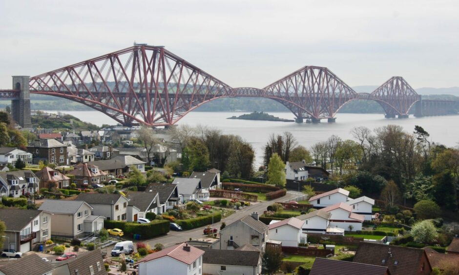
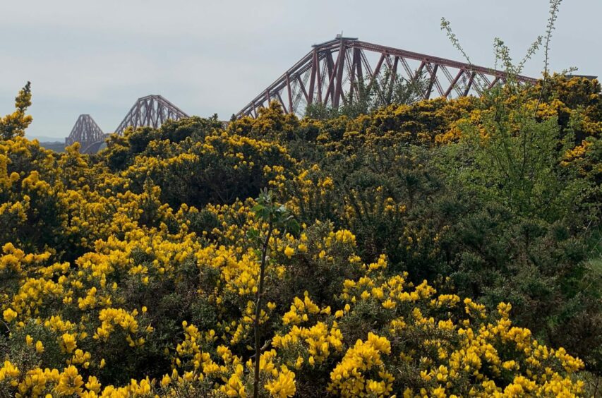
It continued into the nature reserve of Carlingnose Point, filled with birdsong and butterflies, where mixed woodland eventually gave way to the increasing brilliant yellow of gorse and then the first glimpses of the deep russet red girders of the Forth Bridge reaching for the sky.
This is where the walk really comes into its own, this magnificent feat of engineering and ingenuity now your companion for the rest of the journey.
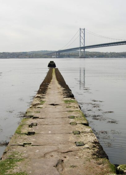
The cobbled path passes under the bridge with the constant rumble of trains passing high overhead to drop into the village of North Queensferry, then heads uphill on the main road again to reach the concrete steps allowing access to the road bridge. However, it’s worth making a short diversion downhill to the pier to take in the sheer scale of the three bridges stretching across the blue. Standing at the end of the slipway, it felt as though I was walking on water.
The crossing provides a fine bird’s-eye view over North Queensferry and the passage is speedy. It’s also surprisingly quiet these days, with the bulk of the traffic now using the Queensferry Crossing.
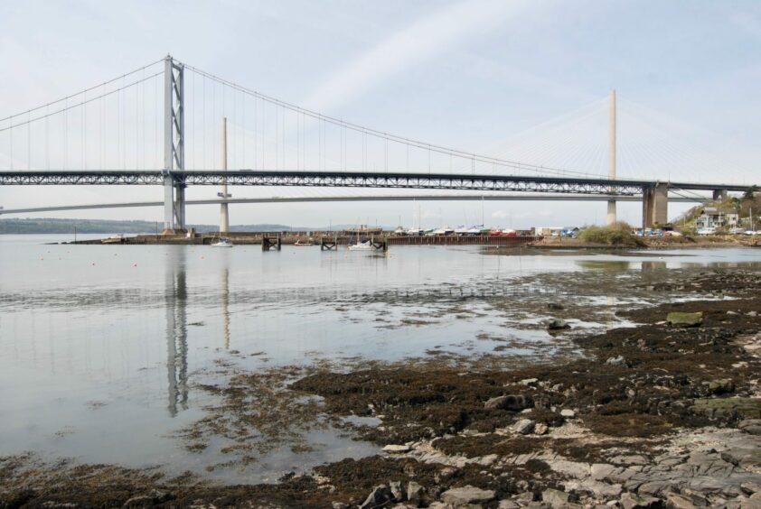
Once on southern shores, I made a turn down left under the bridge then followed the road east until it reached South Queensferry’s quaint High Street, an eclectic mix of historic buildings and quirky shops, cafes and hostelries, plenty of choice for refreshments.
The route left the narrow streets and continued along the waterfront into adjoining Dalmeny with constant fresh views of the bridges. After passing the famous Hawes Inn and under the concrete pillars of the rail bridge, I headed uphill to the right where a sign pointed the way to the station.
There’s a slight sting in the tail with a long, steep set of wooden steps to climb, before a signed series of twists and turns along various paths lead to your destination. Then you can sit back and relax and retrace your route from the comfort of your seat as the train heads back over the bridge on the home leg.
ROUTE
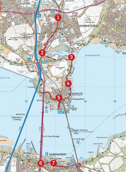
1. Walk uphill from station, exit on Chapel Street heading left. Continue on to Church Street passing old parish church and keep following road under rail bridge, then turn left into Ferryhills Road (sign for Fife Coastal Path).
2. Turn left again almost immediately on to Cruickness Road and follow path signs round edge of huge scrapyard and then quarry above Inner Bay.
3. Path wheels right at harbour mouth, heading south along shoreline of Inverkeithing Bay and passing through wooded section to reach sandy bay of Port Laing.
4. Continue through Carlingnose Point wildlife reserve before passing under Forth Rail Bridge and dropping into North Queensferry. Short detour downhill to pier is worthwhile for fine low-level views of the three bridges.
5. Return to main street and follow it round (ignore one left turn) to reach steps on right giving access to road bridge and cross.
6. After completing bridge crossing, turn left following road down into South Queensferry, then turn right to reach town’s High Street.
7. Pass along front and under rail bridge then head uphill to right where signs direct you up wooden steps and along paths to Dalmeny station.
INFORMATION
Distance: 10km/6miles
Ascent: 200m/656ft
Time: 2.5-4 hours
Grading: Pleasant leg stretch for all ages and abilities mostly on pavements and tarmac with one section on Fife Coastal Path. Best tackled on a fine day – the bridge can be closed to pedestrians and cyclists in high winds. Dogs under close control going through nature reserve.
Start/finish: Inverkeithing rail station (Grid ref: NT 131833).
Map: Ordnance Survey 1:50,000 Landranger Map 65 (Falkirk & Linlithgow); Ordnance Survey 1:25,000 Explorer sheet 367.
Tourist Information: VisitScotland, St Andrews iCentre, 70 Market Street, St Andrews, KY16 9NU (Tel 01334 472021) or Edinburgh iCentre, 249 High Street, Edinburgh, EH1 1JY (0131 4733820).
Public transport: Regular train and bus services to Inverkeithing and Dalmeny.


