Kippenrait Glen, Dunblane, Stirlingshire
Beautiful Kippenrait Glen lies between Dunblane and Bridge of Allan and is at the heart of a fine loop between the towns linked by two historic thoroughfares, the Glen Road and the Darn Road.
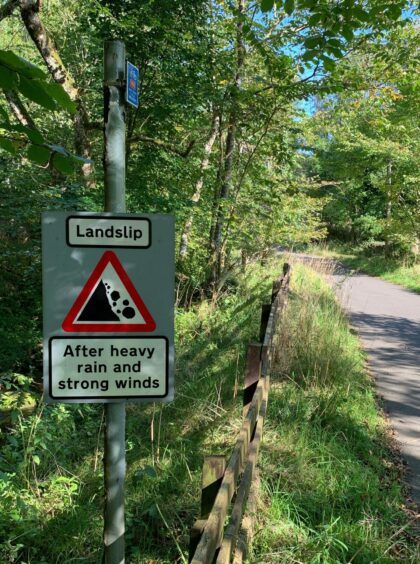
The former was a public road which was closed in 1987 due to landslips, but sterling work by volunteer groups have ensured that it is now a pleasant and popular route for cyclists, runners and walkers.
The Darn Road, which runs by the Allan Water, dates back centuries. Although its true line has likely been altered over the years, it was still a vital connection for horse and cart until the mid-1800s when the newer Glen Road became more popular.
Dunblane has been a key crossing point throughout history. Roman marching camps were sited here around AD80 as they erected up a line of watchtowers heading north, and the town was also an early beacon for pilgrims.
Mary, Queen of Scots, held parliament here in 1558, but the town’s prominence had already been on the wane following the reformation and it had sunk into poverty. The cathedral was said to have sat roofless for 300 years.
The circuit can be tackled from either town with a break for lunch or a coffee at whichever midway point you choose, but we decided to go against the Roman way and do it south to north, starting from the car park behind Dunblane Cathedral. The cathedral and the nearby museum are well worth a visit: entry is free but donations are welcome.
The way to the Glen Road heads past St Blane’s Church, named for the Celtic missionary from Bute who established a pilgrimage centre here in the 11th Century. A careful crossing of the main road led us gently uphill, on pavements at first then gradually leaving the residential and becoming quieter to reach a set of bollards, beyond which the surfaced track became traffic-free.
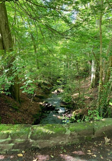
We crossed the old stone Wharry Bridge and followed the leafy trail as it twisted above the burn. The glen is a fine mix of ash, birch, oak and elm and a haven for bird and insect life, but there are still signs warning of the possibility of landslips.
Those fancying a shorter day can cross the next bridge on the right to reach the Darn Road earlier, but we headed downhill into the outskirts of Bridge of Allan before locating the signed turn to indicate the way back north.
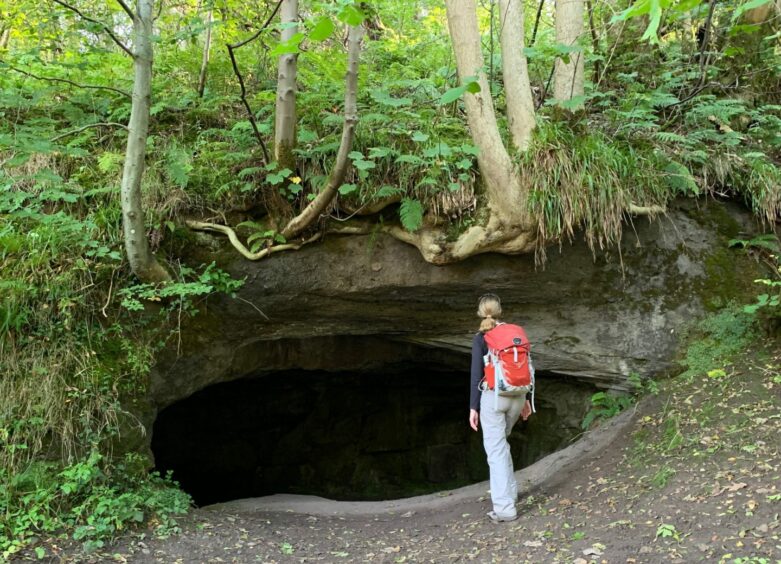
The return journey doubles down on the delights as the path follows the sparkling Allan Water, ducking into shaded woodland, then going down a curious little stepped gully and over a wooden bridge before opening out near a prominent cave.
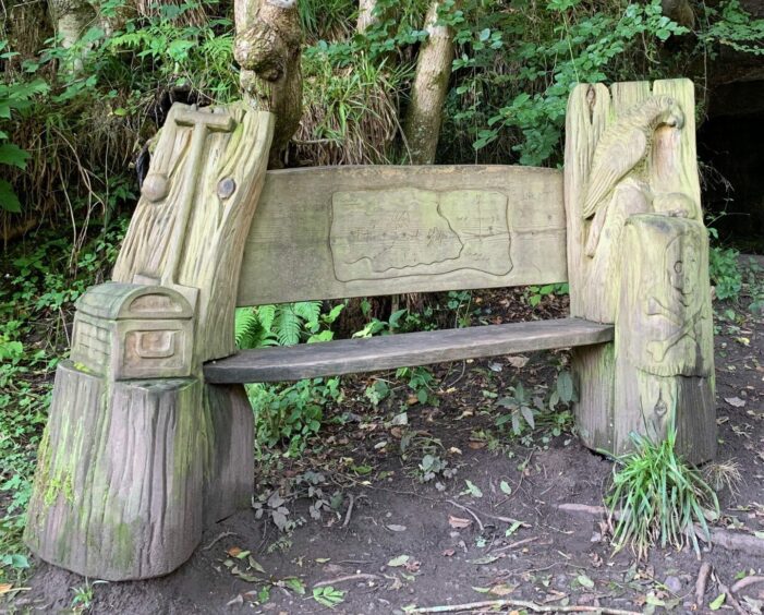
This was said to be a favourite spot of Robert Louis Stevenson, the cave sparking an inspiration for the character Ben Gunn in his seafaring adventure Treasure Island, published in 1883. Born in Edinburgh, Stevenson was plagued by ill health as a child, and his family would regularly holiday in the area which had become popular spa towns for the Victorians.
It’s also said that his pirate Long John Silver was based on a family friend, a giant of a man who had lost a leg and charged around using a crutch. The Treasure Island theme is emphasised by an ornately carved wooden seat next to the cave.
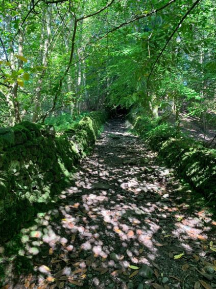
Further on, the path crosses the Wharry Burn and goes up a dark rocky ramp between two moss-covered drystone walls before coming out on the golf course. There’s a short walk along the edge of the pristine greenery to find a path branching off left, which leads down to the road and then back into Dunblane.
ROUTE
1. From car park, walk past cathedral and head up Sinclairs Street to left of Tappit Hen public house. Turn right round St Blanes Church, then left up High Street to Fourways roundabout.
2. Cross road and head uphill on Glen Road (pavement). Road narrows before heading into countryside then further on becomes traffic-free at small car park and bollards.
3. Cross Wharry Bridge to continue through woodland above Kippenrait Glen. Ignore right turn signed for Darn Road. Pass three more bollards then head down towards Bridge of Allan.
4. Keep right at fork with Upper Glen Road, then further down keep left on Glen Road. Turn right at end and head down Ferniebank Brae into Blairforkie Drive.
5. Turn left for a short distance, cross road and watch for sign on right (Darn Walk to Dunblane) which leads down steps towards river to link with woodland path.
6. Follow path along river, descending sunken gully to cross bridge over Cock’s Burn then continue in woodland beside Allan Water to reach cave on right.
7. Keep heading along riverbank, ignoring bridge on left, to reach Kippenrait Glen. Cross wooden bridge over Wharry Burn and head up rocky path between mossy dykes.
8. Keep straight ahead on grassy track which emerges at golf course. Walk along edge of course with care until bearing left on narrow path.
9. Path drops to dual carriageway. Cross and head down road opposite towards High Street and back round cathedral.

INFORMATION
Distance: 8.5km/5.3miles
Ascent: 175m/574ft
Time: 2.5-3.5 hours
Grading: Easy loop from Dunblane to Bridge of Allan suitable for all ages and abilities on woodland paths and tracks, minor roads and pavements. Muddy in places, exposed tree roots and boulders which could be slippy, sturdy footwear advised. Be careful when walking along edge of golf course, and when crossing main road.
Start/finish: Car park behind Dunblane Cathedral (Grid ref: NN 781014).
Map: Ordnance Survey 1:50,000 Landranger Map 57 (Stirling & The Trossachs); Ordnance Survey 1:25,000 Explorer sheet 366.
Tourist Information: VisitScotland, Stirling iCentre, Old Town Jail, St John Street, FK8 1EA (Tel 0131 472 2222).
Public transport: Regular bus and train services to Dunblane and Bridge of Allan.


