Craigendarroch, Ballater, Deeside
The rugged little tree-clad Craigendarroch is the prominent lone peak sandwiched between the Deeside village of Ballater and the deep cleft of the Pass of Ballater.
Its ascent is short and sharp and despite its brevity the climb is steep and sustained. It is rough underfoot at times and despite the short overall distance, there is a surprisingly remote feeling during the loop round its northern side.
The name translates as the rocky hill of the oaks – a few hundred years ago the oak trees from these slopes were used to make cartwheels – although pine and birch are the more dominant cover these days.

It is a fine hill at any time of year, but during the winter months the well-signed and maintained path and shelter of the trees mean that for most of the walk you are protected from the worst of the elements.
There was no snow during my last visit, just a few spots of light rain blowing in the wind, but the depth of fallen leaves covering the path in the lower reaches meant I found myself swishing my way uphill anyway through an ankle-deep copper, rather than white, blanket.
I started out from the car park at the Victorian railway station buildings in the centre of the village. The station was destroyed by fire in 2015, but has since been lovingly restored. There are plenty of other parking options nearby.

I turned right on pavement along the A93 and after passing the old church, followed the signs to the right up Craigendarroch Walk. Another sign at the end of this road directed me on to a path going through a wooden gate to reach a marker post in the woods.
Now it was a left turn on the zig-zags heading uphill, then a right at the next marker post. There were a few fallen trees but most had been cut and tidied away. The path gained height quickly and became increasingly rocky, twisting and turning its way among clinging heather and exposed tree roots.

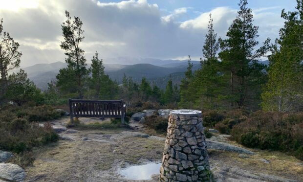
The walk soon opened out to reveal a massive well-constructed cairn atop a staircase of flat granite slabs, with an information plaque sitting alongside. The views over Ballater were superb, an intricate insight into the grid pattern of the streets below.
The true summit of the hill lay a few steps further on, marked by a viewpoint indicator sitting on a large slab with a handy bench nearby for a lunch stop while drinking in the panorama. Some will be happy with their effort at this point and reverse their journey, but it’s well worth carrying on out the back and completing the circuit.
The path narrowed as it dropped down rocky steps then took a swing down to the right to reach a junction. A right turn would lead back round to the start, but I took a sharp left to head along the flank, at one point crossing a rough and innovative ‘ladder’ which had been artistically hewn from fallen trees.

The feeling of remoteness increased with the walk high above the steep forested slopes, with glimpses of the vertiginous faces of the climbers’ favourite, Creag an t-Seabhaig, across the pass.
This is the darker side of the hill, greener and wetter, filled with soaking mosses and wispy lichens and an abundance of the grey hoof-shaped fungus, birch polymore, which had colonised so many trees. There was also a number of wood ant nests, conical piles of pine needles spread through the trees.
The angle eased and the light began to return as the canopy thinned then reverted from pine to oak again. The path swung round by an old moss-coated wall and then turned again to emerge at the earlier point of ascent.
From here it was simply a case of swishing my way back through the leaf-covered path and retracing my steps through the streets of Ballater.
ROUTE
1. Turn right on to A93 heading towards Braemar. After passing old church turn right up Craigendarroch Walk and further on take signed path through wooden gate to reach marker post in woods.
2. Turn left taking path zig-zag uphill until reaching another marker post where you should turn right heading uphill. Path becomes steeper and rockier before emerging at large cairn and viewpoint. The main summit is a little further on with a view indicator and bench seat.
3. Head straight on following black marker on narrow path which weaves its way downhill then to right until turning round to reach junction with another signpost.
4. Turn left on path as it twists and turns, eventually heading left above steep slopes with views of Pass of Ballater crags through trees.
5. Path levels out and follows old moss-covered wall round to the left before reaching junction where you started climb.
6. Carry on straight ahead as path drops back to gate and then walk back round to station.
INFORMATION
Distance: 5km/3.2miles
Ascent: 285m/935ft
Time: 1.5-2.5 hours
Grading: Woodland and hill paths on rugged little peak, suitable for anyone with reasonable level of fitness, though probably not for small children. Care needed – some steep and rough ground with rocky steps and exposed tree roots which could be slippery in wet or icy conditions. Good footwear essential. Some pavement walking.
Start/finish: Old Royal Station, Ballater (Grid ref: NO 369959), other parking available nearby.
Map: Ordnance Survey 1:50,000 Landranger Map 37 (Strathdon & Alford) or Map 44 (Ballater & Glen Clova); Ordnance Survey 1:25,000 Explorer sheet OL59.
Tourist Information: VisitScotland, Ballater iCentre, Station Square, Ballater, AB35 5QB (Tel 01339 755306).
Public transport: Buses to Ballater on Aberdeen-Braemar (No 201) route.


Conversation