Meallach Mor, Glen Tromie, Highland
Meallach Mor is one of those hills that can often be described as shy or retiring, a summit far off the beaten track that is largely ignored by the majority of walkers.
Although the name ‘big hump’ hardly suggests inspiration, this modest Corbett hidden away deep in Glen Tromie gives a fine day out where solitude is likely to be the order of the day.
The distance may be long but the effort is not comparable, even with the high-level return over a series of rolling slopes. This is a walk to be savoured, and the reward for reaching this lonely summit is one of those ‘wow’ moments that suddenly changes the nature of what has gone before.
The route starts from the hamlet of Drumguish just to the east of Tromie Bridge, reached by a minor road off the B970 where there is a series of parking spots among the pinewoods. A short walk uphill and through the houses leads down into the main estate road up Glen Tromie.
This starts off pastoral, the track slipping between fields then mixed woodland and following the run of the River Tromie, but after passing the bridge leading to Glentromie Lodge and then the more modern Lyneberack Lodge a little further south, the glen opens out with a wilder, emptier feel.
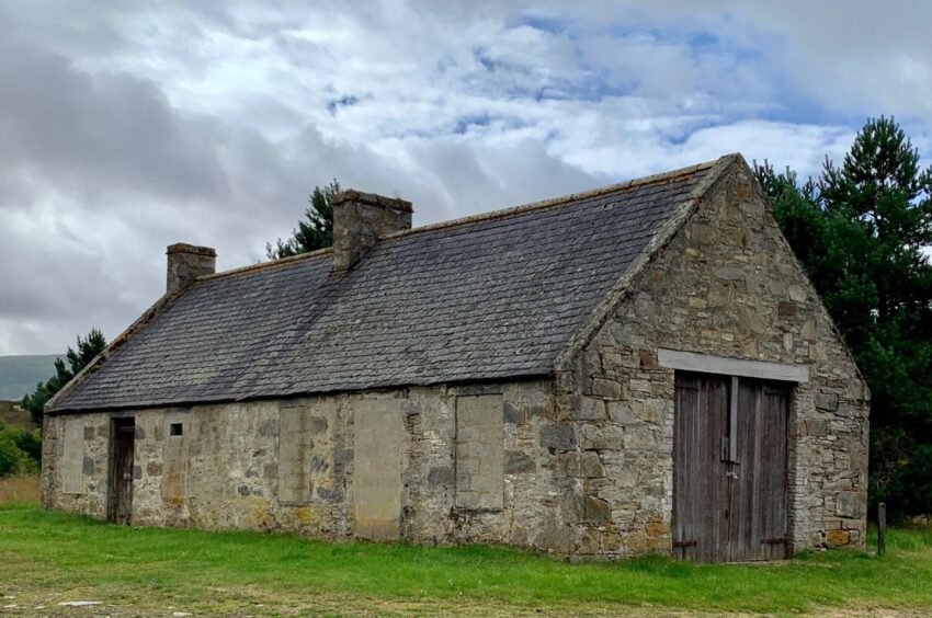
In centuries past, this was a thriving area for farming, and there are numerous shielings and ruins scattered throughout. The building with the red roof off to the right is a locked estate bothy, and with the trees now thinned the high return is now visible on the left.

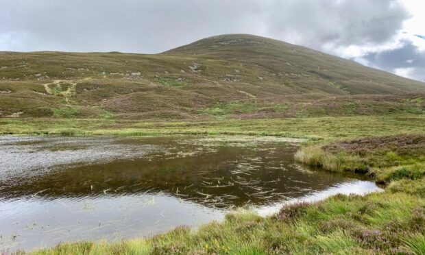
Once past the deserted and boarded-up Bhran Cottage, it’s time to take to the open slopes for the short climb to Meallach Mhor. The best ascent is to the south of the Allt an Tulaich and a small, reed-covered lochan.
It’s pathless through heather and boulders at first but the going improves with height and there’s even a faint path that suddenly appears to help ease the way. However, the major boost for the uphill struggle comes from the sensational view that starts to open up.
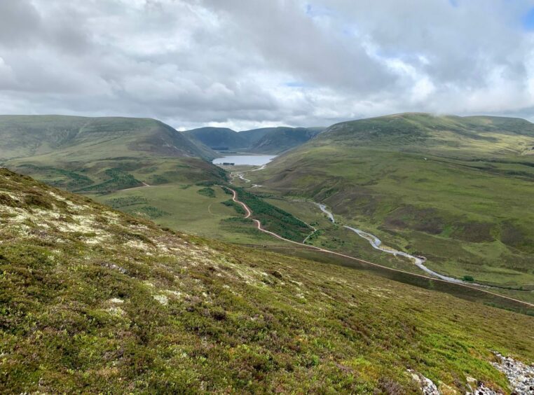
The Munro of Meall Chuaich is the highest point in the jumble of hills to the west, but the finest vistas are to the south with the track snaking off into the distance through a deep trough where Lochan t-Seilich is symmetrically cradled between plunging slopes.
This is the historic Gaick Pass, which slices through the landscape before being joined by the equally famous Minigaig to head in tandem all the way to Glen Garry and the A9. The once huge cairn on Meallach Mhor is now a pile of rubble, but the views all around remain superb.
There’s a real feeling of remoteness here, but the return miles are soon eaten up. A fast drop to the north reaches a wet but obvious atv track which curls round and up on to the long ridge of Clach-mheall which sports a small cairn at its northern edge.
The path onward is vague in places but the line is true and soon passes over the cairn that marks the summit of Croidh-la and, shortly after, another high point with a trig pillar.

The path keeps a high line above the treeline until reaching a junction with a track dropping into Gleann Chomhraig. I went left here, sticking with the path through the heather, a meandering line that often felt as if it was going in the wrong direction, but in the end all was well as it swung round to emerge on the inward track.
From here, it was simply a case of retracing my steps down the glen, before turning right and heading back to Drumguish and the pinewoods.
ROUTE
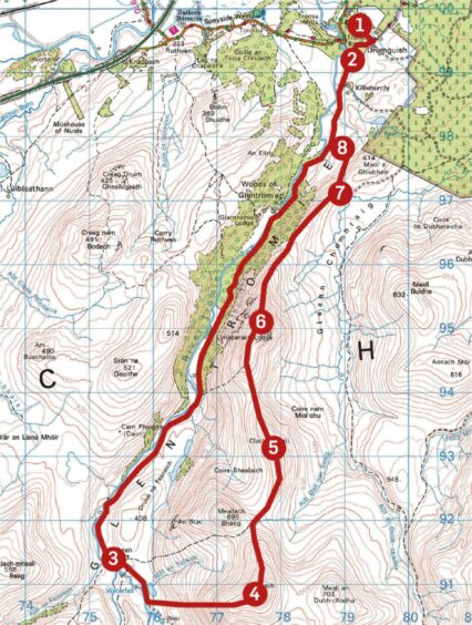
1. Walk up road into Drumguish, turn right at track junction and down past houses on rough track into Glen Tromie.
2. Turn left on to main track and follow south-west alongside line of River Tromie. Pass entrance to Glentromie Lodge (on right) and then Lynaberack Lodge and stay on track until reaching empty Bhran cottage.
3. Shortly after crossing the Allt an Tulaich a little further on, leave the track, passing to right of small lochan, to climb east over rough, pathless ground. Higher up, a faint path leads to large summit cairn of Meallach Mhor.
4. Descend north on heather slopes to join path running along eastern flank of Meallach Bheag. This becomes a wet and sometimes faint atv track which swings round to climb to cairned top of Clach-mheall.
5. Descend north-west to bealach before swinging north to reach summit cairn on Croidh-la then continue along ridge to trig pillar.
6. Pass through gate in fence across ridge and keep following path along higher ground above treeline to reach path junction above Gleann Chomhraig.
7. Keep left on narrow path which twists downhill through trees and heather to emerge on incoming track in Glen Tromie.
8. Turn right and retrace steps north, then turn right at signpost and walk back up through Drumguish to woods.
INFORMATION
Distance: 23km/14.5miles
Ascent: 685m/2250ft
Time: 6.5-8.5 hours
Grading: Long, strenuous circuit for well-equipped hillwalkers with good level of fitness and relevant skills. Estate track on outward leg, rough pathless ascent to exposed summit area then hill paths, sometimes faint, over succession of high points for return. Dogs under close control around farm livestock.
Start/finish: Parking on verges in woods near Drumguish (Grid ref: NN 792996), access by minor road off B970 east of Tromie Bridge.
Map: Ordnance Survey 1:50,000 Landranger Map 35 (Kingussie & Monadhliath Mountains); Ordnance Survey 1:25,000 Explorer sheet OL56.
Tourist Information: VisitScotland, Aviemore iCentre, 7 The Parade, Grampian Road, Aviemore, PH22 1RH (Tel 01479 810930).
Public transport: None to start.


