Calendar An icon of a desk calendar. Cancel An icon of a circle with a diagonal line across. Caret An icon of a block arrow pointing to the right. Email An icon of a paper envelope. Facebook An icon of the Facebook "f" mark. Google An icon of the Google "G" mark. Linked In An icon of the Linked In "in" mark. Logout An icon representing logout. Profile An icon that resembles human head and shoulders. Telephone An icon of a traditional telephone receiver. Tick An icon of a tick mark. Is Public An icon of a human eye and eyelashes. Is Not Public An icon of a human eye and eyelashes with a diagonal line through it. Pause Icon A two-lined pause icon for stopping interactions. Quote Mark A opening quote mark. Quote Mark A closing quote mark. Arrow An icon of an arrow. Folder An icon of a paper folder. Breaking An icon of an exclamation mark on a circular background. Camera An icon of a digital camera. Caret An icon of a caret arrow. Clock An icon of a clock face. Close An icon of the an X shape. Close Icon An icon used to represent where to interact to collapse or dismiss a component Comment An icon of a speech bubble. Comments An icon of a speech bubble, denoting user comments. Comments An icon of a speech bubble, denoting user comments. Ellipsis An icon of 3 horizontal dots. Envelope An icon of a paper envelope. Facebook An icon of a facebook f logo. Camera An icon of a digital camera. Home An icon of a house. Instagram An icon of the Instagram logo. LinkedIn An icon of the LinkedIn logo. Magnifying Glass An icon of a magnifying glass. Search Icon A magnifying glass icon that is used to represent the function of searching. Menu An icon of 3 horizontal lines. Hamburger Menu Icon An icon used to represent a collapsed menu. Next An icon of an arrow pointing to the right. Notice An explanation mark centred inside a circle. Previous An icon of an arrow pointing to the left. Rating An icon of a star. Tag An icon of a tag. Twitter An icon of the Twitter logo. Video Camera An icon of a video camera shape. Speech Bubble Icon A icon displaying a speech bubble WhatsApp An icon of the WhatsApp logo. Information An icon of an information logo. Plus A mathematical 'plus' symbol. Duration An icon indicating Time. Success Tick An icon of a green tick. Success Tick Timeout An icon of a greyed out success tick. Loading Spinner An icon of a loading spinner. Facebook Messenger An icon of the facebook messenger app logo. Facebook An icon of a facebook f logo. Facebook Messenger An icon of the Twitter app logo. LinkedIn An icon of the LinkedIn logo. WhatsApp Messenger An icon of the Whatsapp messenger app logo. Email An icon of an mail envelope. Copy link A decentered black square over a white square.

Parts of Angus faced with yellow wind warning as forecasters warn of gales

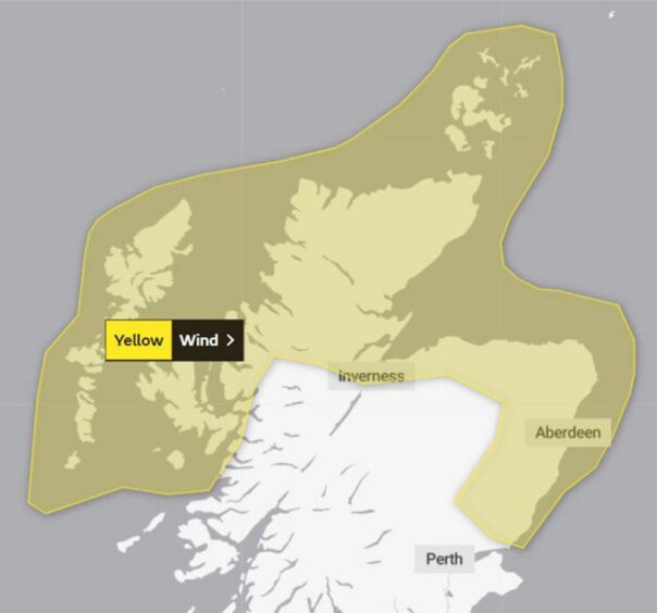
Residents in parts of Angus have been warned of potential disruption this weekend as weather forecasters issue a yellow warning for wind.

Several areas in Angus are included in the warning, with those living in Montrose, Forfar and Carnoustie likely to be affected.

Aberdeen and the Highlands will see the worst of the winds with exposed areas warned of gusts of up to 80mph, but experts at the Met Office have predicted gales of 38mph in parts of Angus.

The current weather forecast for Forfar predicts strong winds and rain throughout the day on Saturday and Sunday, but the rain is likely to be heavier in Kirriemuir.

Weather warning Angus
Most of the north of Scotland is affected

Winds are expected to be at their strongest at around 3pm on Saturday, with gusts of up to 37mph in Forfar and 35mph in Kirriemuir.

Carnoustie is also covered by the yellow weather warning, with gusts of between 35 and 38mph on Saturday.

“Windy with rain on Saturday, turning drier and brighter in the afternoon. Windy on Sunday with rain in the west at first, otherwise mostly dry. Mainly dry on Monday,” the Met Office said.

The warning covers both and Sunday, with a similar forecast for wet and windy weather in most of Angus.

Issuing the warning, the Met Office said the “very strong winds” are likely to result in some travel disruption and “dangerous coastal conditions across northern Scotland”.

It is currently in force from 8pm on Saturday November 6 until 5pm on Sunday November 7.

With coastal areas likely to be the worst hit, the Met Office said residents in these areas could be affected by spray, large waves and flooding.

“Some delays and disruption to road, rail, air and ferry transport are likely. Delays for high-sided vehicles on exposed routes and bridges likely

“Some isolated, short-term losses of power or mobile phone signal are possible,” they added.