Vast swathes of Dundee and Broughty Ferry could be lost to the River Tay if global warming continues unabated.
A new interactive map called Surging Seas shows just how much of the city could be lost over the next century if ice caps melts and the sea levels rise.
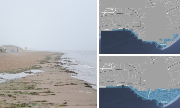
Just a two degree increase in temperature would see City Quay and large parts of Riverside Drive under water.
Large parts of the Port of Dundee would also be flooded.
In Broughty Ferry, Castle Green would be completely submerged as would parts of the Esplanade and Castle Street.
Click the button below to see how Broughty Ferry could be affected by surging seas
If temperatures rise by four degrees the devastation will be even more apocalyptic with the River Tay projected to rise to the East Marketgait circle.
Almost all of Broughty Ferry would be flooded.
Created by Climate Central, an organisation of scientists and journalists, the maps are intended to show what could happen if carbon use is not reduced.
The website states: “They do not show what sea levels will be in this century.
“What they do show are scientific projections, of the different post-2100 sea levels that could lock in this century, depending upon the carbon pathway we select.
“The areas colored blue are the areas below those levels – areas which will eventually be permanently underwater.
“Some research has suggested that the West Antarctic Ice Sheet has begun an unstoppable collapse, but the evidence is far from conclusive.
“The maps here do not assume inevitable West Antarctic collapse. If collapse has in fact begun, all locked-in sea levels would be higher than shown.”
Dr Richard Dixon, director of Friends of the Earth Scotland, said: “These predictions show the very real threat to Dundee and the surrounding area from climate change, which will bring not just higher sea levels but bigger storms on top of those higher seas.
“Every coastal community is going to have think about what changes are coming, what can be protected and what might need to be abandoned to the sea.
“The data here show very clearly that a world which is two degrees warmer is a serious problem for parts of the area but a world which is four degrees warmer is much worse, with the airport and docks unusable and Broughty Ferry south of the railway station under water.
“We need to make sure we do everything we can to reduce emissions so we don’t get anywhere near the four degree scenario.
“Holding back the sea is difficult and expensive and protecting one part of the coast can make problems worse elsewhere. Sadly, sometimes the best answer has to be to retreat to higher ground, giving up on areas that cannot be protected.”
Dundee City Council has invested heavily in flood defences and the local authority recently declared a climate change emergency.
SNP councillor Christina Roberts said: “Sea levels will rise in Dundee and there is also greater risk of surface water flooding in the city with the predicted wetter climate.
“However, flood protection measures are designed to take into account the UK Met Office Climate Projections worst case scenarios to ensure the city is protected against extreme events.
“An adaptation Strategy is also being developed for the City covering a whole range of actions across various sectors, including infrastructure, emergency response, health and biodiversity.
“Planning at this stage will ensure communities, buildings and the natural environment are resilient to future climate impacts.”