Wildcat Trail, Newtonmore, Cairngorms
The Wildcat Trail is an orbital path around the village of Newtonmore which should prove ideal for parents looking for child-friendly walks during the Easter school break.
The whole circuit shouldn’t take more than four hours, but it can also be done in bite-size pieces which may be preferable for younger children.
It breaks into six sections, each of which can be joined at different points, each with its own character and constantly changing mountain views.

The wildcat has long been associated with Newtonmore as the area has close links with Clan Chattan which uses the wildcat as its crest.
The chances of seeing one of these elusive animals during the walk is rare, but there is one spot where kittens are known to have been born.
Go on a ‘cat hunt’
The young ones will enjoy spotting the cat symbols on the regular signposts, and there is the opportunity to go on a ‘cat hunt’ with colourful models scattered around the village.
It’s worth checking in at the Wildcat Centre on the main street for details.
The circuit starts from the rail station. Walk back out past a row of cottages, turn left then left again to reach the level crossing which allows access to the path running along a field edge to the River Spey.
Along an old coffin road
The path follows the banks of the river through gates and over stiles then under a rail bridge, the line of an old coffin road, a route taken by burial parties heading to the cemetery at Banchor.
After passing the confluence of the Spey and the River Calder, the path comes out at the A86, then continues across the road.

There’s a short climb past the graveyard on to a narrow woodland path high above the Calder with the waters rushing through the gorge far below your feet.
The ascent leads to a fine viewpoint and, just beyond, the glen road.
A right turn along the tarmac soon reveals a marker pointing into Milton Wood, but this short loop is currently closed due to storm damage.
Watch out for the mud
Instead, stay on the road until reaching a track on the left going uphill past cottages to a straggling wood where cattle graze. There’s some serious mud to be negotiated here! After going through another gate, keep following the path along the edge of the wood, passing the well-built wildcat cairn.
There are a couple of optional diversions, one to the Craggan viewpoint, the other to an ancient hut circle.
At the end of the woods, exit by a high gate. The route used to head down by the Allt Laraidh but a section of the trail has collapsed and is too dangerous for walkers.

Turn right and follow the track down to Strone Road which curves to the right to reach the main road.
A short walk along the pavement reveals a marker across the road pointing down a lane beside the Highland Folk Museum – also well worth a visit – over a rail bridge and on to a path round the golf course which reacquaints you with the Spey.
This mix of woodland, meadow and wetlands is filled with birdsong. There are a few stepping stones en route, and soon a stile is reached where a right turn leads back along the field edge to the station.
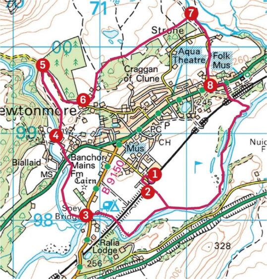
ROUTE
1. Head up Station Road, turn left at end of row of cottages, then left again (signed) to reach level crossing and cross into fields.
2. Walk down field edge to River Spey, turn right and follow path along river bank as it curves to pass under rail bridge and then road bridge to reach River Calder.
3. Stick with path until it emerges on A86 at Calder Bridge, cross road and immediately opposite go through gate on left heading uphill past cemetery.
4. Climb few wooden steps to continue high above gorge to seat and viewpoint. Shortly after, path emerges on Glen Banchor road.
5. Turn right and head along tarmac. Ignore next sign heading into woods loop – this section is currently closed. Keep walking down road, and after passing to left of house take track on left (signed for Golden Acre).
6. Head uphill past cottages, go through metal farm gate on to muddy track. This runs through birch woods to reach another gate where path turns left. Follow through series of gates and stiles until it comes out of high gate on open ground.
7. The next section by the Allt Laraidh is closed due to a landslip, so turn right on to track, pass through high metal gate to reach Strone Road, turn right and follow it down to A86.
8. Head left along pavement for short distance then across to lane opposite (signed), cross rail bridge and go left on path to footbridge then walk round edges of golf course by Spey. Eventually cross stile and head right back to level crossing and station.
INFORMATION
Distance: 10.5km/6.5miles
Ascent: 115m/380ft
Time: 2.5-4 hours
Grading: Well-signed circuit for most abilities on riverside and woodland paths, tracks and minor roads. Can also be walked in shorter sections, ideal for younger children. Very muddy in places, sturdy footwear recommended. Route passes through fields with sheep, cattle and pigs, dogs under strict control.
Start/finish: Newtonmore rail station (Grid ref: NN 716984), limited parking available.
Map: Ordnance Survey 1:50,000 Landranger Map 35 (Braemar & Blair Atholl); Ordnance Survey 1:25,000 Explorer sheet OL56.
Tourist Information: VisitScotland, Aviemore iCentre, 7 The Parade, Grampian Road, Aviemore, PH22 1RH (Tel 01479 810930).
Public transport: Regular bus and train services to Newtonmore from Perth and Inverness.